
|
|
Area/Range |
|---|---|
|
|
53.10590°N / 4.02855°W |
|
|
Hiking, Mountaineering, Trad Climbing, Sport Climbing, Toprope, Bouldering, Mixed, Scrambling |
|
|
Spring, Summer, Fall, Winter |
|
|
3278 ft / 999 m |
|
|
Overview
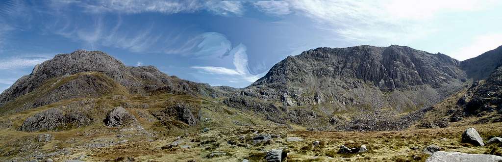
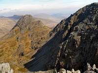
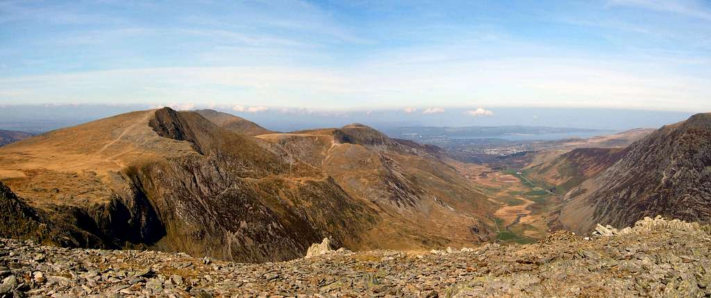
The Glyders, or more correctly Glyderau, are one of the most expansive areas of land above 2000ft in Wales, and are a major feature of the Snowdonia National Park. The range runs from Mynydd Llandegai in the north-west to Capel Curig in the south-east, and sit between two of the area's major mountain passes, the Llanberis Pass in the south and Nant Ffrancon (Cwm Ogwen) in the north. These valleys separate the Glyders from Snowdonia’s highest mountains, with Snowdon to the south and the Carneddau to the north. As a result the mountains offer some of the best views in the whole of Snowdonia and have been the vantage point for many a postcard photo. The range contains five of Snowdoia’s 14 +3000ft peaks including Glyder Fawr (999m), Glyder Fach (994m), Y Garn (947m), Elidir Fawr (923m) and Tryfan (915m). In addition there are a number of other notable mountains, several of which fall within the Hewitt classification (Hill in England, Wales or Ireland over Two Thousand feet high) including several that are above 800m: Foel Goch (831m), Carnedd y Filiast (822m) and Y Foel Goch (805m). Each of these mountains are worthwhile ascents in their own right, and when summited together create a hugely rewarding traverse. The Glyders boast some of the finest scrambling and rock climbing in the whole of Wales and are covered by two Climbers' Club Guidebooks: Ogwen for the northern part, and Llanberis for the south of the range. When in condition the range is also home to some of Snowdonia's best winter climbs, with the sheltered northern cwms often holding onto snow and ice much longer than their more exposed neighbours. Among the highlights are Tryfan, a sharp pyramidal mountain whose easiest line of ascent is a fun Grade 1 scramble, and has a plethora of lines of various difficulties peppering its northern and southern gullies and buttresses. It's reputed to be impossible to ascend the mountain without using ones hands. The range has a long history of rock climbing and is one of the birthplaces of British rock climbing, with the likes of O. G. Jones, G.W. Young, J.M. Archer Thompson, the Abraham brothers, Colin Kirkus and Menlove Endwards recording multiple first ascents here. The little cottage of Helyg, which sits underneath the precipitous north face of Gallt yr Ogof, is the longest surviving mountain club hut in Britain. Acquired by the Climbiers' Club in 1925, the hut played a pivotal role in the development of Welsh climbing in that “Golden Era” between 1925 and 1939 as the base for a close knit group of climbers including J. Longland and the aformentioned Kirkus. The hut is mentioned as early as 1862 by George Borrow in his travel book 'Wild Wales which he describes as a “miserable hovel”. Thankfully things have changed since the 19th century and the hut can be booked out through the Climbers Club website. |

The Glyders from Clogwyn y Person, Snowdon. The mountains from left to right: Y Garn (947m), Pen-yr-Ole Wen (978m; background), Glyder Fawr (1,000m), Glyder Fach (994m), Crib Goch (923m) and Moel Siabod (872m; background)
(Photo by Nanuls)
(Photo by Nanuls)
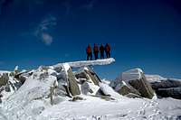
Among the ranges most distinctive features are the heavily weathered summits of Glyder Fawr and Glyder Fach which are characterised by a series of large rocky tors. The trors were formed during the last ice age when the mountain tops protruded above the ice as nunataks, and were exposed to thousands of years of intense weathering. These features such as Castell y Gwynt and the Cantilever Stone offer some fantastic bouldering opportunities in a stunning setting. The mountains are also home to Llyn Idwal, one of Britain’s most beautiful and most ecologically important lakes. Lying in a deep hanging valley in the shadow of the Devil's Kitchen it is an extremely popular destination for rock climbers, walkers and anglers. Its habitats are considered to be so special that it is protected by both international European law as a Special Area of Conservation and a Ramsar site. Another of the ranges famous lakes is the Llyn Marchlyn Mawr Reservoir on the northern flank of Elidir Fawr, which is used by the Dinorwig Power Station, as part of a 1728 MW hydroelectric pump-storage system, that operates through a man-made cavern within the mountain. At times of peak electricity use, water is quickly pumped through six 288MW turbines reaching peak production within 6 seconds. |


Summits of the Glyders
The Glyders take their name from the range's two highest mountains Glyder Fawr and Glyder Fach. This may seem obvious but it's worth pointing out that these are just two of the attractions the range has to offer and that the range is home to several other well known Welsh mountains that shouldn't be missed. Hopefully the map and list below illustrate this point. Okay a quick explanation about what qualities made these summits eligible to be on this map and list - to put it simply they must qualify to be on at least one of the UK’s official mountain lists, any of them. Hover your mouse cursor over the map to find out what lists the peaks belong to. Now I’m sure some of SummitPost’s international users, and probably a good number of British ones, will be scratching their heads and wondering what the hell some of these lists mean (Buxton & Lewis anyone!?!). Well I’m not going to tell you, because there just isn’t room here to explain them all fully, however if you are wondering here are some links to some relevant pages, several of which are already here on SP – Hewitt, Nuttall, Marilyn, Buxton & Lewis and Dewey. Interactive Map Interactive ListThe table is interactive; click on the name of the mountain to be taken to its SP page, and click on the map symbols on the right hand side of the table to be taken to either a 1:25,000 or 1:50,000 map of the immediate area. |
| No. | Photo | Name | Metres | Feet | Grid Reference | 1:25K | 1:50K |
|---|---|---|---|---|---|---|---|
| 1. |  | Glyder Fawr | 999 | 3278 | SH642579 |  |  |
| 2. |  | Glyder Fach | 994 | 3261 | SH656582 | | |
| 3. |  | Castell y Gwynt | 972 | 3189 | SH654581 | | |
| 4. |  | Y Garn | 947 | 3107 | SH630595 | | |
| 5. |  | Elidir Fawr | 924 | 3031 | SH612613 | | |
| 6. |  | Tryfan | 915 | 3002 | SH664593 | | |
| 7. |  | Foel-goch | 831 | 2726 | SH628612 | | |
| 8. |  | Carnedd y Filiast | 821 | 2694 | SH620627 | | |
| 9. |  | Mynydd Perfedd | 812 | 2664 | SH623619 | | |
| 10. |  | Y Foel Goch | 805 | 2641 | SH677582 | | |
| 11. |  | Gallt yr Ogof | 763 | 2503 | SH685585 | | |
| 12. |  | Y Fronllwyd | 720 | 2362 | SH617631 | | |
Geology
The main structural feature of Snowdonia is of course the broad belt of rugged mountains that runs diagonally across it through from the Carneddau to Snowdon, with the Glyders forming the central mass of peaks. It corresponds with the complex downfold of Ordovician rocks known as the Snowdon syncline.
 Bedrock geology of North Wales Bedrock geology of North WalesThe oldest rocks (Pre-Cambrian) in the region are found to the of the range on the island of Anglesey. They consist of metamorphosed sedimentary and volcanic rocks over 6000m thick, highly deformed by earth movement. Lower Palaeozoic rocks mark the development across the area of a great depositional trough in which accumulated thousands of metres of marine sediments. The lower rocks (Cambrian) rest unconformably on the older formations. This trough marks the establishment of a sedimentary basin that covered all of Wales, much of England, parts of Ireland and extended into Belgium. The basin was situated on the edge of a continental mass which lay to the south-east, with the Iapetus Ocean on the north-west. At the end of the Cambrian, slight uplift exposed the erosional deposits, and a new period of submergence during the Ordovician, led to more deposition and more unconformity. Volcanic activity is the outstanding feature of the Ordovician period. Vulcanism spread throughout the region and eventually culminated in eruptions of central Snowdonia giving birth to Glyderau as well as Snowdon and the Carneddau. This volcanic activity coincided with the continued deposition of marine sediments and was a prelude to the later closure of the Iapetus Ocean. Though volcanic activity ceased at the end of the Ordovician, marine sedimentation continued into the Silurian. At the end of the Silurian, earth movements culminated in the Caledonian Orogeny, a major period of uplift, folding and fracturing which partly destroyed the marine trough and resulting in the closure of the Iapatus Ocean and the resultant continent-continent collision. The Lower Palaeozoic seas retreated from North Wales and the strong earth-movements transformed the landscape, and the marine rocks of the Cambrian, Ordovician and Silurian periods were replaced by the continental rocks of the Devonian period. Subsequent erosion has revealed the major Caledonian structures such as the Snowdon Syncline and the Harlech Dome just to the south (Rhinogydd). The Devonian period is followed unconformably by strongly transgressive Carboniferous rocks. The marine transgression in the Carboniferous covered most of North Wales with only the highest mountains probably remaining unsubmerged as islands. A second period of major earth movement (Hercynian) affected the Carboniferous and older rocks, with the main movements occurring along existing fractures. Apart from Pleistocene and recent sediments, no post Hercynian sedimentary rocks are found in Snowdonia. |

During the Tertiary era, North Wales was situated at the edge of a landmass which was undergoing uplift in relation to the development of the North Atlantic Ocean. The uplift of the landmass during the Tertiary resulted in intensive erosion of overlying rocks, exposure of the Lower Palaeozoic rocks forming the Snowdon Syncline and Harlech dome, and development of an upland plateau. The uplift resulted in the dominant primary drainage directions of the North Wales area. The river systems formed part of an extensive drainage system draining the uplifted continent towards the south-east. The denudation of the mountains and the carving out of the valleys took place in stages. In parts of Snowdonia, imperfect plateau surfaces occur, probably the result of erosion controlled by higher base levels (river erosion). They were primarily developed by river erosion controlled by an intermittently falling base level (rejuvenation). Some of the plateau surfaces (below 180m) are thought to have been marine cut and end abruptly as if along a cliff line. The low-level coastal platforms are definitely pre-glacial and the whole series of erosion plateau surfaces indicate a falling base level in the Tertiary period. The higher surfaces are thus older than the lower ones and are less well preserved. Rivers in the Tertiary rejuvenation, exploited structural weaknesses and created some river capture, which in turn caused more rejuvenation. All evidence now points to the fact that the Glyder area was deeply dissected by rivers attempting to grade themselves to a succession of lower base levels, down to levels less than 60m above sea level. Although glaciers have considerable deepened the valleys and later-glacial rivers also, the main valleys and mountain outlines were already in existence prior to the Pleistocene glacial phases e.g. Nant Ffrancon and Llanberis Pass. The modern physical landscape and geography of Snowdonia mainly reflects the influence of intensive glacial erosion during the Pleistocene epoch. During the late Pleistocene glacial phase, a large British Ice Sheet developed in response to global cooling. This ice sheet developed by coalescence of several ice centres, one of which was centred in North Wales. Welsh ice was centred on the Migneint Plateau and the Arenig Mountains with outlet glaciers radiating from that centre. These outlet glaciers carved fairly extensive glacial trough valleys, some good examples are the valleys of Nant Ffrancon and the Llanberis Pass. Deposits were dredged in frozen conditions from the floor of the Irish Sea by ice approximately 700m thick. During phases of more severe climatic conditions, Welsh ice quickly spread over the coastal plains and south Anglesey preventing the Irish Sea ICe from advancing. Erratics from the mainland have been recorded on the west of Anglesey, so the coast was subject to Welsh and Irish ice at different times, thus tills of both are found. During this period the tops of the highest peaks protruded above the ice sheet as nunataks, with large areas around Snowdon, the Glyderau and the Carneddau undergoing extensive periglacial weathering. The majority of glacial landforms found beyond the mountain areas were last formed or modified during the last glacial maximum approximately 18,000 yrs BP (Dimlington Stadial). The freshest glacial deposits and landforms plus those found in high mountain areas were last formed/modified during the last glacial even (Loch Lomond Stadial or Younger Dryas) approximately 11,000 - 10,000 yrs BP. Snowdonia is an area which once supported local glaciers during the Loch Lomond Stadial. Glaciers emerged from the cwms and were channelled down existing valleys (carved during the previous glacial phases), and in a few cases carved out new ones. The post-glacial landscape evolution has largely developed through landscape adjustments especially isostatic rebound (uplift), slope modification and coastal processes (including sea-level rise). |
Wildlife and Conservation
The Glyders are part of the Eryri/Snowdonia Special Area of Conservation (SAC), and are therefore strictly protected under the EC Habitats Directive. Snowdonia SAC covers an area of 19737.6 hectares (197 square km) and includes within its boundaries many of Snowdonia's highest mountains including Snowdon, the Glyders, and the Carneddau.
 Eryri/Snowdonia SAC Eryri/Snowdonia SACThe area is rich with important habitats, according to the Joint Nature Conservation Committee (JNCC), who are the statutory adviser to Government on UK and international nature conservation, Snowdonia has the best-developed and most extensive areas of Siliceous alpine and boreal grasslands in Wales and is the largest example of the habitat type south of Scotland. The principal sub-type present is U10 Carex bigelowii – Racomitrium lanuginosum moss-heath, but there are also fragments of U7 Nardus stricta – Carex bigelowii grass-heath. Snowdonia SAC is also the largest site in Wales representative of siliceous scree. The site has extensive screes of igneous rocks with large stands of U21 Cryptogramma crispa – Deschampsia flexuosa vegetation; associated species include fir clubmoss Huperzia selago. Bryophyte and lichen-dominated screes are also well-represented and include important populations of rare and local montane and oceanic species, such as Marsupella adusta, Marsupella stableri and Cornicularia narmoerica. The area also contains the most extensive and diverse examples of hydrophilous tall herb fringe communities in Wales. Fragmentary stands of the habitat type occur on pumice tuff and other base-enriched igneous rocks at a range of altitudes throughout the site. The vegetation is floristically somewhat impoverished compared with Scottish examples but includes many of the species found further north, such as globe-flower Trollius europaeus, wild angelica Angelica sylvestris and holly-fern Polystichum lonchitis. It is important as a southern outlier for arctic-alpines such as alpine saw-wort Saussurea alpina and black alpine-sedge Carex atrata. There are also some southern species, which are absent further north, for example Welsh poppy Meconopsis cambrica. Snowdonia is representative of Calcareous rocky slopes with chasmophytic vegetation at one of its most southerly outposts in the UK, and contains the most extensive and diverse examples of these communities in Wales. Crevices in base-rich igneous rocks support a characteristic assemblage of plants, with a large number of arctic-alpine species. These include a number of nationally rare species, such as alpine saxifrage Saxifraga nivalis, tufted saxifrage S. cespitosa, alpine meadow-grass Poa alpina and alpine woodsia Woodsia alpina. A species of particular interest is the Snowdon lily Lloydia serotina, which in the UK occurs only in Snowdonia, in rock cracks and crevices on calcareous and more siliceous substrates, and is here at its northern limit in western Europe. The site also has extensive examples of Siliceous rocky slopes with chasmophytic vegetation right at the southern edge of the habitat types range. Acidic crevice communities occur throughout the site on igneous outcrops and include populations of stiff sedge Carex bigelowii, fir clubmoss Huperzia selago and forked spleenwort Asplenium septentrionale. Atlantic species, including Wilson’s filmy-fern Hymenophyllum wilsonii and a wide range of bryophytes, are also well-represented. Llyn Idwal, located just to the north of Glyder Fawr, represents a fine example of oligotrophic waters, so much so that it has also been designated a Ramsar site under the 1971 Ramsar Convention on Wetlands. It is a relatively small, shallow, upland corrie, in contrast to Llyn Cwellyn, also in Snowdonia, and complete ice cover has been recorded in winter. No overall change in the lake’s water chemistry has been found since the mid-19th century, and the water quality is considered to be high. The site has a good representation of typical plant species, including quillwort Isoetes lacustris, water lobelia Lobelia dortmanna, shoreweed Littorella uniflora, bulbous rush Juncus bulbosus, alternate water-milfoil Myriophyllum alterniflorum and intermediate water-starwort Callitriche hamulata. Bog pondweed Potamogeton polygonifolius has been recorded from stream inlets, and pillwort Pilularia globulifera is reported from this site. Emergent and floating vegetation is mainly confined to the shallow sub-basin at the south end of the site, where floating bur-reed Sparganium angustifolium forms extensive mats, alongside stands of common reed Phragmites australis, water horsetail Equisetum fluviatile and bottle sedge Carex rostrata. |
 Tryfan (Photo by Nanuls) Tryfan (Photo by Nanuls) |  Devil's Kitchen (Photo by Phillip Stasiw) Devil's Kitchen (Photo by Phillip Stasiw) |  Llyn Idwal (Photo by BigLee) Llyn Idwal (Photo by BigLee) |
Wildlife in the area is in abundance with some 50 species of flower, around 50 species of fern, nearly 50 species of moss, 7 species of clubmoss, around 50species of lichen, over 70 species of fungus and fungoid, over 60 species of hornwort, quillwort, stonewort and liverwort, and nearly 30 species of conifer occupying the valleys and mountain sides of the area. Countless insects feed upon and live within this vegetation with some 40 species of butterfly, over 50 species of moth, around 50 species of beetle, around 50 species of spider, 6 species of grasshopper, 15 species of hymenoptera (bees, wasps and ants), 16 species of dragonfly, as well as countless other species of insect. There area also around 50 species of molluscs, 5 species of crustacean. Within the sites lakes, streams and marshes live a plethora of amphibians and fish including 3 species of Lamprey, and 14 species of bony fish including Brown and Rainbow Trout, Atlantic Salmon, and European Eel. Of the amphibians living in the area are the Common Frog, Common Toad and Palmate Newt. Although rarely seen reptiles also live within the area including the Adder, Common Lizard, Grass Snake and Slow-worm. Among the species of mammals that can be found there are Feral Goat, Brown and Mountain Hares, Grey and Red Squirrels, European Rabbit, European Mole, Eurasian Badger, Pine Marten, Polecat, stoat, Weasel, Red Fox, European Otter, West European Hedgehog, Brown Rat, three species of mice, three species of shrew, two species of Vole and no less that thirteen species of bat. General site character Inland water bodies (standing water, running water) (2%) Bogs. Marshes. Water fringed vegetation. Fens (15%) Heath. Scrub. Maquis and garrigue. Phygrana (19.7%) Dry grassland. Steppes (34%) Alpine and sub-alpine grassland (1%) Broad-leaved deciduous woodland (0.3%) Inland rocks. Screes. Sands. Permanent snow and ice (27%) Other land (including towns, villages, roads, waste places, mines, industrial sites) (1%) Information provided by the Joint Nature Conservation Committee |
 Glyder Fawr (left) and Glyder Fach (Right) (Photo by Nanuls) Glyder Fawr (left) and Glyder Fach (Right) (Photo by Nanuls) | 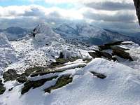 Glyder Fawr (Photo by mtnbiker converted) Glyder Fawr (Photo by mtnbiker converted) |  Cneifion Arete (Photo by Phillip Stasiw) Cneifion Arete (Photo by Phillip Stasiw) |
Mountain Activities
There’s Something fore everyone here, from easy hikes to technical rock climbing to valley bouldering. HikingHiking is probably the most popular activity that takes place in the Glyders, with easy hikes to all the summits bar Tryfan. Owing to the encirclement of the range by two main roads access is easy with plenty of parking along Llanberis Pass and Nant Ffrancon. This is supplemented in summer months by the Snowdon Sherpa bus service which acts as a conveyor for outdoor enthusiasts throughout Snowdonia. The highlight of the area is probably a traverse of the range from Nant Perris in the west to Capel Curig in the east (or visa versa depending on how you feel).The quality of the route can be attested to by it's inclusion in Vancouver Islander's article Five Best Dayhikes of a Lifetime. It's a personal perspective of course, but goes to show that I'm not the only one who thinks that the relatively small mountains of Snowdonia can offer a world class experience.
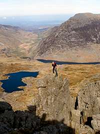 Bristly Ridge, Glyder Fach(Photo by Nanuls) Bristly Ridge, Glyder Fach(Photo by Nanuls)ScramblingThe numerous ridges and gullies of the range are home to a considerable number of scrambling routes, many of which are extremely popular and can now rightfully be deemed as British classics. It is reputed that it is impossible to climb Tryfan without harnessing ones hands, not that one would want to try, as the scrambling the mountain has to offer is such a joy. In fact, what is probably the best easy scramble in all of Wales can be created by combining an ascent of Tryfan via its North Ridge and and ascent of Glyder Fach via Bristly Ridge, to form the route known as the Bochlwyd Horeshoe. Other classic scrambles can be found all along the northern aspect of the range, with the more serious Cneifion Arete among its best. Rock Climbing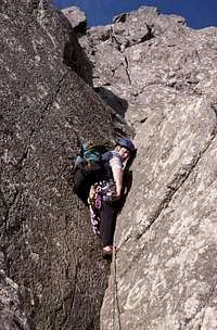 First pitch on the Grooved Arete, Tryfan (Photo by Dan Bailey) First pitch on the Grooved Arete, Tryfan (Photo by Dan Bailey) Direct Route, Tryfan (Photo by DrJonnie) Direct Route, Tryfan (Photo by DrJonnie)Many aspiring British climbers will have cut their multi-pitch teeth on one of the Glyders many rock faces. The area is home to such a concentration of rock climbs that it is covered by two Climbers Club guides and one more general guide which also covers the rest of Snowdonia. The crags of the Ogwen Valley are home to some wonderful and historic climbs, including the famous Grooved Arete (HVD 244m) fist climbed by E.W. Steeple in 1911; and The Devil's Kitchen/Twll Du (VD 24m) first climbed by W.R. Reade and P. Mculloch in 1898. The rock on the southern side of the range is more varied in nature. Dinas Cromlech for example offers one of the highest concentrations of good quality difficult routes, both single and multi-pitch anywhere in Britain. Lines such as Cenotaph Corner (E1 5c), Resurrection (E4 6a 44m), Lord of the Flies (E6 6a 40m) and Ivory Madonna (E5 6b 80m ) proving every bit as challenging as they are reputed to be. Those looking for something easier will find much to enjoy on one of John Melove Edwards' classic routes Flying Buttress (VD) and Sprial Staircase (VD). Further to west towards Llanberis the relics of a once bustling slate industry has scarred the landscape, but with it created some interesting environments for climbers to enjoy. The challenge of slate climbing is quite different to anything else in the range, the low friction and friability of the rock can be unnerving for the uninitiated. Dinorwig quarry has some fantastic climbs, and the popularity of the area means that most lines are clean and free of both vegetation and loose rock. However extra care must be taken when quarry climbing as the durability of the rock face can vary and what may seem like a rock solid (pardon the pun) hold to begin with, may prove to be somewhat unreliable. Winter Climbing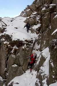 North Ridge of Tryfan (Photo by BigLee) North Ridge of Tryfan (Photo by BigLee) Climbing on Bristly Ridge, Glyder Fach (photo by sadeik) Climbing on Bristly Ridge, Glyder Fach (photo by sadeik)The northern Cwms of the Glyder Range were born of the great ice sheets that inundated the area for much of the Pleistocene Era, and today although the ice climbing might not be up to the standards of 50,000 years ago, they hold some of the best lines in Wales. Cwm Idwal is the birthplace of Welsh Winter Climbing, when in 1895 J.M. Archer Thompson scaled the cascade of ice and snow that tumbled forth down the rear of the Devil's Kitchen. Owing to their northerly aspect the steep, sheltered cliff faces are able to hold snow and ice long after the accumulations on neighboring larger mountains have withered and gone. This is an all essences, the heart of Welsh Winter climbing. Although there are climbs on all the major peaks, the greatest density are located around the northern cliffs of Glyder Fawr, with each of its glacially carved corris and hanging valleys holding an array of lines - which in all fairness vary in quality significantly. Among the best and most popular are Left Hand Branch (IV 120m) on Clogwyn Ddu, and South Gully (IV 140m) on Clogwyn y Geifr, also known as The Devil's Kitchen Cliff. Bouldering Pass of Llanberis (Photo by Nanuls) Pass of Llanberis (Photo by Nanuls)Bouldering guidebooks tend to deal with the subject in terms of valley areas, probably because the vast majority if exploration has centered around the easily accessible boulders close to the main roads. However with a bit of jiggery-pokery I think I can describe what the area has to offer in mountain terms. Remember though, that although this section only describes boulders that fall within the Glyder range, a short distance away (e.g. across the road) there may be even more bouldering, it just won't be mentioned here. Bouldering in Wales grew up and matured around the mountains to the south and east of Llanberis, of which the Glyders occupy a significant area. The area is now well explored and is known to have some of the best bouldering in Britain. Of particular note are the Cromlech Boulders located high in the upper reaches of the Llanberis Pass. With easy access and a massive density of quality problems ranging from around V0- to V11, the area is rightfully popular and are definitely worth visiting by anyone – from novices to experts. It is fortunate that the boulders exist at all, as on the 6th of December 1973 they were within an hour or two of being blown up by the Gwynedd County Surveyor’s men for road widening purposes. Luckily for us, locals, climbers, historians, conservationists, geologists and the ordinary people from all over Britain, had been campaigning diligently for the boulders to be saved, and at the 11th hour they were saved through a direction from the then Secretary of State for Wales, Peter Thomas.  Ogwen Valley (Photo by Jans Man) Ogwen Valley (Photo by Jans Man)Although less popular the north side of the range also has much to offer, with boulders and small crags dotted around Ogwen Cottage, and along the A5. The far eastern flank of the range is home to the lesser known RAC Boulders, which offer a good range of fun mid-grade problems away from the crowds that often plague the Cromlech Boulders. Another plus point for the RAC Boulders is that they are located in a nice little sun-trap, making them ideal for winter bouldering or when the sun sets over the generally sheltered and cold flanks recesses of the Llanberis Pass. |
Mountain Conditions
This section displays the mountain conditions for Snowdonia of which the Glyderau are a part. The information is provided by the Met Office and is issued twice per day. It is valid for the full 24 hour period on each day. Click on the widget for maps and further information. | This Snowdonia weather forecast is generated by the Met Office Weather Widget |
When To Climb and Essential Gear
This being, on a global level, a relatively small range, the mountains can be climbed at anytime of the year however in poor conditions some routs are best avoided particularly if visibility makes route finding difficult. Of course this all depends on ones ability as a mountaineer/climber, and what might be comfortable for some may seem daunting for others. It is worth noting that some areas of rock, particularly those that have been heavily abraded, can become very greasy when wet. If your lucky enough to climb the mountains in winter conditions, then an ice axe (or ice axes on the harder routes), crampons, a helmet, a rope and a decent winter rack (if going for a more serious route) are all essential. |
Mountain Rescue
Wales has fourteen Mountain rescue services, seven of which operate in the Glyder area. They are mostly staffed by local volunteers and funded primarily by public donations. They operate with the assistance of local Police, and in serious situations an RAF helicopter from RAF Valley. The West Wales Air Ambulance also helps out when necessary. The services work is not just restricted to mountain and wilderness rescue; often teams are utilised by the local police to search for missing or vulnerable persons in the community. The Mountain rescue services operating in the Glyder area are: Llanberis MRT Ogwen Valley Mountain Rescue Organisation In emergency situations Mountain rescue services can be contacted by ringing one of the UKs standard emergency service numbers: 999 or 112
|


Red Tape
Unlike the national parks of North America and certain parts of Europe, there are no permits required for entry into the park, no visitor limits or any other kind of red tape designed to restrict access. Since the passing of the Countryside and Rights of Way Act (CRoW) 2000, the public have the right to access almost all the land within the national park boundary regardless of ownership. Open access land is denoted by the signs below.
|


Certain locations of interest to climbers are subject access ro restrictions, some of which are only seasonal, or just affect specific parts of the location. In the Glyder area, these include Gideon Quarries, the Lower Slate Quarries and the Upper Dinorwic Quarries. One crag is subject to seasonal restrictions associated with nesting birds: Clogwyn y Geifr (1st of March - 30th of June), which is in Cwm Idwal. For more information on the status of restricted areas, see the BMC's Regional Access Database. |
Getting There
 Adam and Eve, Tryfan (Photo by Nanuls) Adam and Eve, Tryfan (Photo by Nanuls) Llyn Padarn and Peris (Photo by vancouver islander) Llyn Padarn and Peris (Photo by vancouver islander) Y Garn (Photo by daveyboy) Y Garn (Photo by daveyboy)Conveniently, is encircled by two main roads the A5 in the north and the A486 in the south and east, meaning that long approaches are a thing of rarity. If approaching from the north or west, e.g. from Liverpool or Hollyhead, turn off the A55 and onto the A5 at the large junction (SH 593 694) that sign posts for Bethesda and follow the road until Llyn Ogwen where parking is available. If coming from the east, take the A5 through Bettws y Coed (SH798 599) and Capel Curig (SH 719 580) which will take you directly to the base of the mountain. If driving from the south, take the A470 through Blaenau Ffestiniog (SH 700 458) to Bettws y Coed, and turn off onto the A5 towards Bethesda which will take you the same way as if coming from the east. There is plenty of parking along the A5 near Tryfan, some of which you have to pay for, some of which you don't. My advice is to never bother with the official car parks and just park along the roadside. There is a wide 'pavement' type verge on the southern side of the road that can easily accommodate the width of a car or minibus, and is completely free and never full (even on bank holidays). It also allows you to park even closer to the base of the mountain and the start of the path. There is also parking to the south at Pen y Gwryd and Pen y Pass. Pen y Pass car park (SH 647 555) is located at the zenith of the Llanberis Pass, and can be reached easily by road on the A4086 that runs between Llanberis (SH 582 598) and Capel Curig (SH 719 580). Owing to the sheer number of routes that start there the Pen y Pass car park often fills up quickly so if you want to park there a very early start is recommended. There is also parking and a good starting point around 1.5km to the east along the roadside near the Pen-y-Gwryd Hotel (SH 660 558). Do not park in the hotels car park as this is for guests only. |
Camping and Accommodation
 Tryfan (Photo by vancouver islander Tryfan (Photo by vancouver islanderThere is plenty of camping in close proximity to the Glyders. For Glyder Fawr, Glyder Fach and Tryfan the Gwern Gof Uchaf Campsite, Gwern Gôf Isaf Campsite and bunkhouse and Garth Farm Campsite can all be found in Cwm Ogwen in the north. There are also a number of YHA hostels in the area, the nearest of which are YHA Idwal Cottage in the north and YHA Pen y Pass in the south, both located within close proximity to the range's main peaks. The Plas y Brenin National Mountain Centre in Capel Curig also has a bunk house, and has its own indoor climbing wall if you still feel energetic after your day on the mountain. My personal recommendation is the bunkhouse above Pete's Eats in Llanberis, a cafe that is a true icon of Snowdonia's climbing scene and is probably the best cafe in all of Wales, if not the world. I also recommend the Pen-y-Gwryd Hotel located just above the Pass of Llanberis between Beddgelert and Capel Curig. The hotel was established 1810 and was the base for much of Snowdonia's early climbing scene, and has been host to many of Britain's pioneering climbers such as George Mallory, Andrew Irving, George and Ashley Abraham, Owen Glynne Jones, Sir Edmund Hillary, Tenzing Norgay, Sir John Hunt, Charles Evans, George Band, Joe Brown, John Angelo Jackson, Wilfred Noyce, Tony Streather, Tom Mackinnon, Norman Hardie, Neil Mather, John Clegg and others including Noel Odell from Mallory's 1924 expedition and Chris Bonnington. Also the nearby towns of Capel Curig, Bettws y Coed and Bethesda all have various hotels, hostels, B&Bs and campsites. |
Maps
|
| Navigation Maps OS 1:25k Explorer Series OL 17 Snowdon/Yr Wyddfa OS 1:50k Landranger Series 115 Snowdon/Yr Wyddfa Harvey Map Services 1:25k: Snowdonia North: Snowdon, Glyders, Carnedds Harvey Map Services/BMC 1: 40k British Mountain Map: Snowdonia North Road Maps |


