
|
|
Area/Range |
|---|---|
|
|
52.78958°N / 3.92392°W |
|
|
Hiking, Mountaineering, Trad Climbing, Bouldering, Scrambling |
|
|
Spring, Summer, Fall, Winter |
|
|
2474 ft / 754 m |
|
|
Overview
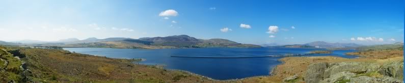
Tucked away in western Meirionnydd, on the periphery of the average visitor to Snowdonia’s conscience, is a range of unambiguous hills known as the Rhinogydd. Distinct from their more dramatic northerly neighbours, they form a rolling sea of rock and heather, only broken by rising waves of small gritstone crags and cragletts. It’s this underlying geology that gives the range its unique character, these rocks are old, far older than the igneous and metamorphic strata that surround them and it gives rise to some distinctly different landforms. Flat, ice polished, rocky plateaus are intersected by steep, deep, glacial breaches, grassy peaks are flanked by short broken crags, which have more in common with the edges of the Peak District than the craigs of North Wales, and wherever water may collect, it does, forming a myriad of tiny lakes, ponds and bogs. It has the feeling of a forgotten landscape, no less because while the remnants of the areas past use can still be seen by those with an eye for them, evidence of its current use is conspicuous by its absence. Few people have heard of the Rhinogydd and even fewer come to visit. As you might have gathered the Rhinogydd, also known as the Rhinogau and often Anglicised as The Rhinogs, is one of Wales' wildest and least visited mountain ranges. It stretches some 20 km from north to south with the largest peaks found in its southern half. The mountains from which the range takes its name, Rhinog Fawr (720m) and Rhinog Fach (712m), are not in fact the highest, as to the south Y Llethr and Diffwys exceed them, reaching 756m and 750m respectively. 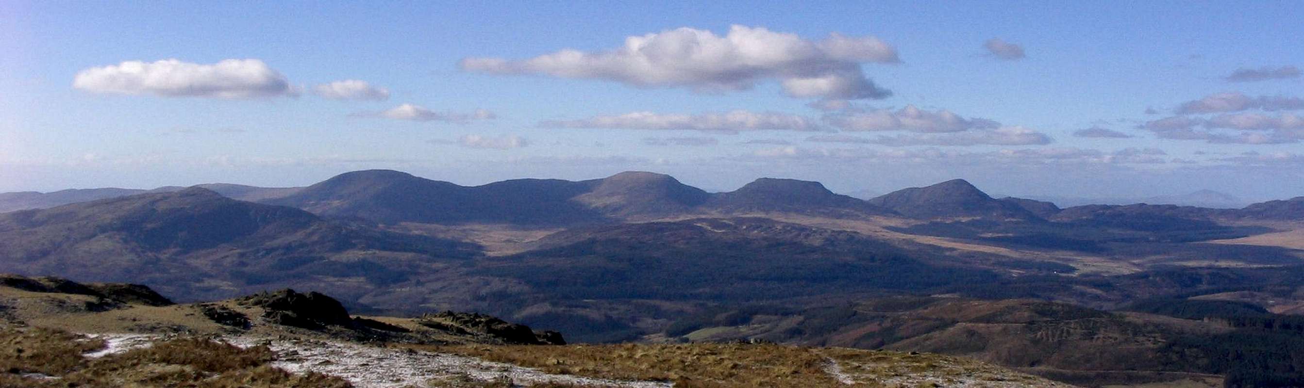 The Rhinogydd. From left to right - Y Garn, Diffwys, Y Llethr, Rhinog Fach and Rhinog Fawr (Photo by Nanuls) Despite their marginally lower height, by far the most spectacular peaks are the aforementioned Rhinog Fawr and Rhinog Fach. Their slopes are steep, rocky and intricate and the routes to their summits always interesting. Rhinog Fach is also home to the range’s longest rock climb, the 172 metre South Ridge (Severe), a minor classic that you are unlikely to have to share with anyone else. While the landscape further north may lose its height, it does not lose its character. Here the landform undulates rhythmically in a north south direction with occasional hummocks, rock exposures and lakes breaking through here and there. The highest points in this area are Moel Ysgyfarnod (623m), and Foel Penolau (614m), twin peaks of distinctly different character. While Moel Ysgyfarnod is in general relatively gentle, grassy and open, Foel Penolau is a steep, rocky and bold outcrop; it is the Mr Hyde to Moel Ysgyfarnod's Dr Jekyll. |


Summits of the Rhinogydd
This table lists the peaks of the Rhinogydd, click on the mountains name to go to its SP page (if one exists). Okay a quick explanation about what qualities made these summits eligible to be in list - to put it simply they must qualify to be on at least one of the UK’s official mountain lists; any of them. Now I’m sure some of SummitPost’s international members, and probably a good number of British ones, will be scratching their heads and wondering what the hell some of these lists mean (Buxton & Lewis anyone!?!). Well I’m not going to tell you, there just isn’t room here to explain them all fully, however if you are wondering here are some links to some relevant pages, several of which are already here on SP – Hewitt, Nuttall, Marilyn, Buxton & Lewis and Dewey. |
| How to use this section: The Map: The map is interactive and you can get name and height information for the mountains by hovering your mouse cursor over the red triangles. When a little 'hand symbol' appears over a triangle it means that there is a page on Summitpost for that mountain, just click on the triangle to be shown the relevant mountain/rock page. Tip: Look out for these  The Table: At the moment this is pretty simple, all you have to do is look at it. The key below explains what the different headings mean. Key
|
| Rank | Photo | Name | M | Ft | Range | Sheet 1:25k | Sheet 1:50k | Grid Ref | Map 1:25k | Map 1:50k | Ma | SM | H | SH | N | BL | D |
|---|---|---|---|---|---|---|---|---|---|---|---|---|---|---|---|---|---|
| 1. |  | Y Llethr | 756 | 2480 | Rhinogydd | 18W | 124 | SH661258 |  |  |  |  | | | | | |
| 2. |  | Diffwys | 750 | 2461 | Rhinogydd | 18W | 124 | SH661234 | | | | | | | | | |
| 3. |  | Rhinog Fawr | 720 | 2362 | Rhinogydd | 18W | 124 | SH656290 | | | | | | | | | |
| 4. |  | Rhinog Fach | 712 | 2336 | Rhinogydd | 18W | 124 | SH664270 | | | | | | | | | |
| 5. |  | Crib-y-rhiw | 670 | 2198 | Rhinogydd | 18W | 124 | SH663249 | | | | | | | | | |
| 6. |  | Diffwys West Top | 642 | 2106 | Rhinogydd | 18W | 124 | SH648229 | | | | | | | | | |
| 7. |  | Y Garn | 629 | 2064 | Rhinogydd | 18W | 124 | SH702230 | | | | | | | | | |
| 8. |  | Moel Ysgyfarnod | 623 | 2044 | Rhinogydd | 18W | 124 | SH658345 | | | | | | | | | |
| 9. |  | Foel Penolau | 614 | 2014 | Rhinogydd | 18W | 124 | SH661348 | | | | | | | | | |
| 10. |  | Moelfre | 589 | 1932 | Rhinogydd | 18W | 124 | SH626245 | | | | | | | | | |
Geology
 Bedrock Geology of Snowdonia Bedrock Geology of Snowdonia Bedrock Geology of the Rhinogs Bedrock Geology of the Rhinogs Sarn Badrig Sarn BadrigThe Rhinogydd are formed of hard sedimentary rock of Cambrian age and the area is known geologically as the Harlech Dome, an anticlinal region separating the Snowdon and central range synclines. This name is derived from the folded, mountainous structure which once extended from Snowdon in the north to Cadair Idris in the south. This Dome has long since been eroded, leaving the valleys and peaks of the Rhinogydd visible today. The legacy of this structure can be seen in the slopes of Snowdon and Cader Idris: Snowdon's south face is far steeper than its north face, whilst Cader Idris' north face is steeper than the south. The mountains form the geomorphological, if not the structural, centre of the Dome and consist of mostly Cambrian rocks surrounded by Tertiary rocks in the west and Ordovician formations, many of which are igneous, in the north, east and south. The main part of the Cambrian formation consists of Harlech Grits, with Mawddwch and Rhobell volcanic groups in the east. During the last ice age, known as the Devensian in Britain, the height of the ice sheet covered all but the highest two peaks, Y Llethr and Diffwys, whose summits protruded above the ice as nunataks. The Welsh Ice Sheet moved across the range from the Snowdon and Aran regions and into the Irish Sea basin where it joined the Irish Sea Glacier and moved south along Cardigan Bay. To the west of the Rhinogydd is Sarn Badrig, the largest and most prominent of three submarine ridges (the other two being, Sarn-y-Bwlch and Sarn Cynfelin) that extend out along the seabed into Cardigan Bay. The ridge rises some 9-12m above the general level of the seabed, has an overall length of approximately 17km and an orientation of 230º. The feature contains erratic from the Aran and Arenig Mountains as well as from the Llŷn Peninsula, and is thought to represent a medial moraine, marking the line of confluence between the Irish Sea and Welsh ice streams. |
Wildlife and Conservation
 Map showing Rhinog SAC Map showing Rhinog SACComposed of hard, acidic Cambrian grits of the Harlech Dome, the Rhinogydd have in consequence a rugged topography with block-littered slopes, numerous cliffs and rock outcrops. Heather (Calluna vulgaris) dominates large areas; low fertility soils, infrequent burning and low grazing levels have resulted in its often rank development. Luxuriant bryophyte carpets often occur under it and northern species including Ptilium crista-castrensis and Anastrepta orcadensis are present. Broad terraces have allowed the development of blanket mire in a dissected pattern and Heather, Cotton Grasses (Eriophorum spp. ) and Deer Grass (Trichophorum cespitosum) are frequently dominant locally with Bog Myrtle (Myrica gale). Valley mires and small upland oligotrophic lakes are other features of the range. The rugged upland and then hillside oakwoods on the range’s lower slopes have outstanding lichen, fern, moss and liverwort populations. Both species of Filmy Fern (Hymenophyllum wilsonii) and H tunbrigense) occur in the woodlands and in block scree. A herd of feral goats (Capra hircus) also inhabit the area and can often be seen wondering across the less accessible parts of the range. Consequently, the range is subject to a number of different nature designations including national Nature Reserve (NNR), Site of Special Scientific Interest (SSSI) and Special Area of Conservation (SAC). The latter of these is an international designation and is therefore strictly protected under the EC Habitats Directive. The Rhinog SAC covers 3144.53 hectares and includes within its boundaries the summits of Rhinog Fawr, Rhinog Fach and Y Llethr. General site character Inland water bodies (standing water, running water) (1%) Bogs. Marshes. Water fringed vegetation. Fens (5%) Heath. Scrub. Maquis and garrigue. Phygrana (75%) Dry grassland. Steppes (8%) Humid grassland. Mesophile grassland (3%) Improved grassland (3%) Broad-leaved deciduous woodland (4%) Inland rocks. Screes. Sands. Permanent snow and ice (1%) |

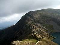
Foel Penolau (Photo by Nanuls)
Historic Landscape
The Rhinogydd form part of the Ardudwy Historic Landscape. It’s considered an area where natural forces and human activity, acting together over the last six thousand years, have contributed to produce a landscape of great beauty and variety, which is considered a national asset that is essential both to Wales’ national identity and to its individual 'sense of place' and wellbeing. In the higher parts of the range there are few signs of past human, with the exception of one or two isolated late prehistoric hut circles in the north. The three main paths through the range follow traditional routes, which have been in use since at least the Middle Ages. The two northern ones lead out of Cwm Bychan (Bwlch Gwilym in the north and Roman Steps/Bwlch Tyddiad in the south), while the other starts in Cwm Nantcol and crosses Bwlch Drws Ardudwy. |


On the lower slopes of the range, the evidence of human activity is much stronger, an archaeological survey of the Moelfre and Mynydd Llanbedr upland area found dozens of sites of archaeological interest of all periods, including early prehistoric cairns and standing stones, hut circles and enclosures, clearance cairns, mounds long huts, building foundations, sheepfolds, mining remains, peat cuttings and many more ephemeral stone features. This plethora of evidence indicates that occupation and human exploitation of this remote area has taken place (not necessarily continuously) for over three or four thousand years. In the north-western region of the range, along the lower slopes of Moel Ysgyfarnod and Foel Penolau, there is evidence that in the later prehistoric period the main focus of occupation was on the fringes of the upland, on the better- drained, west-facing hill slopes. This is indicated by numerous settlements of various forms surviving where modern agriculture has not been too intensive. These sites consist of a hillfort on Moel Goedog with other remains concentrated between Moel-glo and Coetty-mawr, with outlying single huts at higher altitudes around Bryn Cader Faner. There is also evidence of small nucleated Bronze Age settlements and associated field systems all along the hillsides at Maes-y-caerau and Moel y Geifr. |
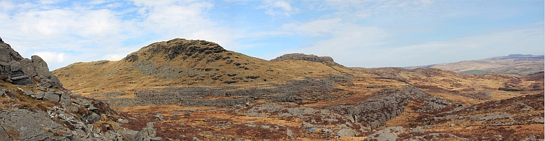
Moel Ysgyfarnod (left) and Foel Penolau (right) (Photo by Nanuls)
The area has remarkably little in the way of an industrial archaeological heritage and there has been very little industrial activity in the past that has left a mark on the landscape. Probably the most significant in landscape terms are the Hafoty manganese mines, but there are also fairly extensive workings around Llyn Eiddew-mawr and further north, on the east slopes of Y Gyrn. There are also the remains of shafts and levels above Coed Crafnant, and on the lower, northern slopes of Moelfre where there are the relatively extensive remains of Moelfre mine along the contour near the modern road and one or two other places. Although due to more intensive farming practices the valleys of Cwm Bychan and Cwm Nantcol contain relatively little prehistoric evidence, there are a number of features dating from the medieval period. The important, sub-medieval house of Maesygarnedd dominates the end of the Nantcol Valley and is associated with John Jones (1597?-1660), who was the brother-in-law of Oliver Cromwell and one of the signatories of the death warrant of Charles I. |


Cwm Bychan also has a fine example of a sub-medieval, two-unit storied house, which is recorded as one of the homes of the patrons of the bards and thus was one of the principal houses of Ardudwy at that time. Further down the valley are a few scattered farmsteads (e.g. Dolwreiddiog, Cwm-yr-afon, Crafnant and Hen Dolbebin) which date from the 17th to 19th centuries. All along the upland area and valleys there are stonewalls built during the 17th to19th centuries and are the most visible aspect of the Rhinogydd’s archaeological history. In the 19th century the emphasis on building appears to have shifted in favour of, first, a village-based followed by a coastal/leisure economy, still largely based around the 19th century village nuclei. Thus the uplands were largely abandoned. This pattern is still very much in evidence today. |
Mountain Activities
HikingFor those in search of wilderness, there can be few better places to walk in Snowdonia than the Rhinogydd. Miles upon miles of heather and rock, rarely touched by the hiker or the farmer, undulate rhythmically from the Mawddach to the Glaslyn, ripe for exploration. One must be a competent navigator to enter here though, there are few paths and those that exist don’t necessarily go where you want them to. It’s worth noting therefore, that when estimating the time it will take to complete route, that your probably going to be wrong; everything takes longer in the Rhinogydd. |

The Mawddach Estuary
(Photo by Nanuls)
(Photo by Nanuls)
The area is too vast to be recommending specific walks in a section such as this, however there are a number of objectives that are worth highlighting. It goes without saying, that both Rhinog Fach and Rhinog Fawr are a must for the first time visitor. Both have good trails, with reasonably clear paths, leading to them. They also tend to be busier than other parts of the range and getting lost is less of a risk. While higher, Y Llethr and Diffwys are of less interest, but do give superb views of their northern neighbours and the scenery across the Mawddach to the South. They are perhaps worth a look, if only for tick of the logbook. In the far north, Moel Ysgyfarnod and Foel Penolau give some superb wild walks, where the chances of meeting another person are slim to none. The view from the summits of these mountains affords a sweeping panorama of northern Snowdonia that shouldn’t be missed, encompassing the peaks of the Eifionydd, Snowdon Group and Moelwynion to name but a few. For those looking for a slightly different view of the range, Y Garn, which is separate from the main Rhinog ridge, is well worth a look. It offers some interesting views across to Diffwys, Y Llethr and Rhinog Fach and a vista to the east and south that includes Yr Aran and Cadair Idris. |


This leaves the centre and peripheries, which are devoid of major summits, to explore. A walk in the central Rhinogydd, starting and ending at Llyn Bychan, is one of the range’s highlights. It takes the hiker on a voyage through one of the wildest and least visited parts of Wales, over heather and ancient ice-polished slabs, past lakes and through canyons and over streams and around bogs; and all this without the aid of proper paths or trails and without the distraction of other visitors. It is the quintessential Rhinog experience. For those looking for some specific suggestions, it is recommended that you consult one of the many fine guidebooks available for the area, the details for some of which are provided in the Guidebooks section of this page. Rock ClimbingDespite the range’s first recorded ascent taking place way back in 1932 (South Ridge of Rhinog Fach, 172m, Severe) and it being well within the line of site of that Snowdonia favourite, Tremadog, little interest was shown in exploring the Rhinogydd until relatively recently. Over the last couple of decades however, a small group of dedicated enthusiasts have combed their way over the range’s crags to produce a sizeable portfolio of mostly quite hard grit climbs. It’s certain though, that this exploration has only just touched the surface of what’s on offer. |


Currently, there are only a handful of climbing guides to the area. The most comprehensive of these is the Climbers’ Club Guide to Wales: Meirionnydd (2002) by Martin Crocker, John Sumner, Terry Taylor, Elfyn Jones, with contributions from Mike Rosser, Mike Lewis and Dave Wrennall. The guide covers the Rhinogydd and the rest of southern Snowdonia, namely Yr Aran (with Cwm Cywarch), Y Berwynion, and Cadair Idris - along with Y Moelwynion (including Cwm Lledr and Betws-y-coed crags), and the recent intensive development of Arenig Fawr. Local climber Terry Taylor, who contributed the Rhinog section to the above book and was responsible for much of the area’s exploration, also maintains the website www.midwalesclimbing.com, which provides info on recent updates in the area. A free pdf providing details of new routes climbed between 2002 and 2009 can be downloaded from this and the Climbers’ Club’s website… or you could just download it here. |
Diffwys from Foel Penolau (Photo by Nanuls)
Another good guidebook comes in the form of Cicerone Press’ The Ridges of England, Wales and Ireland (2009) by Dan Bailey. Obviously this guide is not exclusive to the Rhinogydd, but does contain a lavishly illustrated description of Rhinog Fach’s South Ridge; it’s a good choice if you don’t plan on spending a lot of time climbing in Meirionnydd, like ridges and don’t mind traveling about a bit. Craig y Gwynt The most northerly crag of the range, Craig y Gwynt faces west and benefits from a sunny disposition. Short and ideal for the soloist (saves carrying gear a long distance), it is home to a number of routes that range in difficulty from D to E3 5c. Moel y Gyfrafolen The northernmost summit of the Rhinogydd is littered with many minor edges, only two of which yield any routes. Craig Fawr has routes ranging from VS 4c to E2 6a, while the smaller Bwlch Diffwys is home to routes of D to E3 6a. Foel Penolau Despite being a relatively well known summit, rock climbing did not arrive at Foel Penolau until 1997; since then a handful of good quality routes have been recorded on its southern side. This is wilderness climbing at its very best and if you want to climb here you will need to make the not inconsiderable effort to drag your gear many miles to experience it. Those that do will find excellent, steep and quick drying rock, which boasts some of the best views in Snowdonia. There’s little for the novice here though, with the easiest route coming in at a respectable Very Severe 4b. Get the most out of your visit by combining your trip with stops off at the crags of Moel Ysgyfarnod or Craig y Gwynt. |


Moel Ysgyfarnod Exploration of the area around Moel Ysgyfarnod did not take off until after 2002 (consequently it is not described in the 2002 Climbers’ Club guide), but it has now arrived, though given the area’s complexity one may find it hard to find the established routes. The climbing is split between a number of small compact buttresses, which surround the peak, namely the South West Escarpment, the Main Wall, the Minus Seven Wall, the Llyn Du Crag and the Llyn Corn-Yswc Crag. For those completely confused by this area, a better option might be to pick your own section of rock and establish your own lines - effectively, this is still virgin territory and much remains to be explored. Clip Set above Cwm Bychan, Clip is perhaps the most viewed hill of the northern Rhinogydd. It comprises of several tiered crags, which yield a number of short routes and are known as levels. Level One is perhaps the least inspiring of the levels, being home to somewhat poor rock. Level Two, is also of minimal interest and is probably best passed on the way to the upper levels. Level Three is the tallest of the crags and is also the best. Eclipse (E2 5c) and Min y Aur (E3 6a), have the potential to be hard grit classics. Level Four can be split into east and west faces and gives three good crack lines, which are worth a look if you can be bothered to walk that far. |

Clip (Photo by Nanuls)
Crags of the Central Rhinogydd The area between Bwlch Gwilym and Bwlch Tyddiad in the south is one of the wildest, least visited parts of the range. Scattered throughout are numerous small crags, which while being troublesome to reach, offer something sublimely unique to those with the tenacity to find them. The furthest north of these crags are those of Craig Swn y Nant and Craig Wion. Both these areas offer nothing over 18 metres in height, but both have a good number of routes, ranging in difficulty from Very Difficult to E6 6b. Running through the centre of this area is an open valley that drains the west side of this part of the range before running westwards into Llyn Cwm Bychan. The remainder of the crags are to the south of this. The valley itself is home to a number great little crags including Clogwyn Spot, Mur Cyddiedig, Craig Smiedde, Two Towered Buttress, Mur y Tonnau and Ysgor Gwyn. Routes range from Difficult to E5 6a/b, with Mur Cuddiedig having the greatest number of easy to mid grade routes. Much further into the range one will find Craig y Groes, an excellent, clean and remote crag that has a good range of routes for the mid to high end climber. The routes are split between two crags known as The Canyon and Isolated Buttress. Highlights include Paradox Squad (E5 6a) and Foggy Dew (E1 5b). Nearby, one will also find Lefn Fan and Crawcwellt Forest Crag, which have fewer routes and are of less interest. |

Central Rhinogydd (Photo by Nanuls)
Further south, just a short walk from Bwlch Tyddiad, is a beautiful little lake known as Llyn Morwynion. Along its eastern shores a series of north facing walls called Carreg y Morwynion, contain a number of routes following the natural features of the crags, some of which are as hard as E6 6b. Further north is the Y Clawdd, classic leaning wall again facing northwards with immaculate compact grit, with routes ranging in difficulty from E1 5b to E5 6a. Check out Gawr (E3 6a), Gwyllt (E4 6b) and Gwen (E5 6a). To the east of the lake is another good crag, Y Grisiau, which is home to a number of good, hard routes including the superb Wilderness Grit (E3 6a). Rhinog Fawr The climbing at Rhinog Fawr is split between a number of small, compact buttress, which litter the north and north-western slopes of the mountain. Many of these crags can prove quite hard to find, but those who make the effort will be rewarded with a number of superb routes on pleasant, clean and compact grit. Of particular note are the routes at Min Pistyll, a pleasantly situated and surprisingly easily located crag in the little valley that spills forth from Llyn Du. The line of note is Emilya (E2 5c), which has all the makings of a micro classic but none of the traffic. The crags that surround Llyn Du also offer a high concentration of starred routes. Llechau Mawr, which are the slabs and crags above the aforementioned lake are home to a number of these, with Martin Crocker’s Rock Steady (E3 5c) being the pick of the crop. The 15m high crag of Uwch y llyn, which is located behind the western end of the lake, a little way up Rhinog Fawr's slopes, also stands out, the best route being the bold and beautiful Mur y Llyn (E1 5a). |


Rhinog Fawr’s South Face also boasts the Rhinogydd’s only scrambling route, which comes in at Grade 3 and ascends a series of broken crags, slabs and boulders to the mountain’s fore-summit, where the scrambling ends, and the true summit is just a short walk away. |
 South Ridge South Ridge(Photo by Nanuls) | Rhinog Fach |  The South Ridge The South Ridge(Photo by Nanuls) |
Cwm Nantcol The crags of Cwm Nantcol have the advantage of being among the easiest to access in the Rhinogydd, being only a short walk from the parking. Moelfre, which is the obvious rounded hill on the southern side of the valley, has on it a north facing cliff and a number of hard short routes, the best of which is Underpower (E5 6b). Further up the valley and on its northern side this time, the western face of Foel Wen is littered with small cragletts that soak up the sun and dry quickly. One of its crags, Gareg-lwyd, has a pleasant collection of routes from Severe to E7 6b. These include The One (E7 6b) an incredible solo on excellent rock with some errant rocks waiting on the ground. Towards the end of the road in the main valley and up towards the Drws is another complex of pillars and boulders within easy reach. These are known as Craig y Cwmnantcol. The 20 metre face on the right end of the complex is home to some more classic Rhinog lines; check out Hanged, Drawn and Quartered (E4 6a) up the clean right wall for some of the best the crag has to offer. Craig Bodlyn Strung out along the shores of Llyn Bodlyn, a lake which had its waters raised by the construction of a dam in 1894, are the north facing crags of Craig Bodlyn, which at their western end, are higher than any other in the range. It is the mother of all Rhinog crags and is fittingly described in the Climbers’ Club guide to the area as “a sort of Frêney amongst Fontainebleau”. It has in many places now succumb to the tendrilled advances of the local vegetation, and those wishing to climb some of the older routes may wish to include a pair of secateurs on their rack. Fear not though, for there are some clean walls to be found here too and one of particular interest is the relatively recently developed Silver Screen. |

Craig Bodlyn (Photo by Nanuls)
This is not a crag for those who prefer their climbing to be easily accessible; there’s no quick way to this spot, with prospective climbers faced with a choice of a long flat approach or a short steep one. Whichever option they choose, they will have to work up a sweat to complete it. Those who do make the effort will be rewarded with some of the longest grit routes in Britain as well as a large number of single pitch lines to boot. Don’t expect an easy time here though, there is only one route graded below Very Severe while the hardest line comes in at a very respectable E7 6c. Craig y Merched On the south-western flank of Y Garn are a series of short boulders, crags and buttresses known as Craig y Merched. With its favourable aspect, quality rock and stunning views, this area is one of the best climbing venues in the range and a must for the Rhinog grit aficionado. Furthermore, it’s detachment from the spine of the Rhinogydd means that even fewer bother to visit it, giving it a gloriously remote feel; this is wild Wales at its very best. Routes are split reasonably evenly between the area’s buttresses, with North Walls, Rhinos Buttress, Three Pillar Crag, and Upper Craig y Merched offering the best climbing, with routes ranging in difficulty from around VD to E2 5c. |


Outlying Crags  Barmouth Slabs Barmouth Slabs(Photo by Nanuls) The Rhinogydd have a number of satellite crags that sit at various points along its margins. These tend to be more popular than the range’s main crags, since being closer to the road, they are in general, far more accessible that their loftier neighbours. Of these, by far the most visited are Barmouth Slabs, which sit high above the Mawddach Estuary just down the road from the eponymous seaside town. Here one will find an excellent beginner’s crag, a fact which is not lost on the numerous outdoor centres that operate in the area. There is also a quarry in Barmouth itself, which was once home to some fantastic moderate to hard routes, however, access is currently banned from this location but hopes are that it may be reopened in the near future. A little further north Craig y Cae and Brynau Glo offer some interest, with the former being home to routes up to five pitches long, which range in difficulty from VD to E4 6a. In the far north, just to the north-west of Trawsfynydd, is another good crag, Garreg yr Ogof, which offers a variety of easy to moderate rock climbs as well as a number of shorter bouldering problems. Overlooking Llyn Trawsfynydd and the range’s northern hills, its setting is something to marvel at. Various crags, such as Llanbedr School Crag, Y Garth and Graig Galch can also be found along the range’s western margin. However, owing to the effort it requires to reach them, they receive less attention than their southern and eastern counterparts. Winter ClimbingUnfortunately, due to the close proximity of these mountains to the sea and the frequent arrival of Atlantic depressions pushing warm, moist air over the range, even in the middle of winter, climbing conditions are infrequent and unreliable. This, combined with the relatively long walk-ins required to reach anything worthwhile, has led to a lack of exploration and recorded winter ascents in the area. However, a number routes have been recorded on Craig Bodlyn, which range in difficulty from Scottish Grade III to V and vary from 70 to 150 metres in length. Descriptions can be found in Cicerone Press’ Welsh Winter Climbs by Malcolm Campbell and Andy Newton. |
Mountain Conditions
This section displays the mountain conditions for the Snowdonia National Park, in which the Rhinogydd are located. Click on the widget for maps and further information. This Snowdonia weather forecast is generated by the Met Office Weather Widget |
When to Climb
This being (on a global level) a relatively small range, the Rhinogydd can be climbed anytime of year, however, in poor conditions some routes are best avoided, particularly if visibility makes route finding difficult. Of course this all depends on ones ability as a navigator, and what might be comfortable for some may seem daunting for others. It's worth noting that gritstone can get very greasy when wet, so unless it's dry, don't even think about climbing it. |
Mountain Rescue
Wales has fourteen Mountain rescue services, only one of which operate in the Rhinog area. They are mostly staffed by local volunteers and funded primarily by public donations. They operate with the assistance of local Police, and in serious situations an RAF helicopter from RAF Valley. The West Wales Air Ambulance also helps out when necessary. The services work is not just restricted to mountain and wilderness rescue; often teams are utilised by the local police to search for missing or vulnerable persons in the community. The Mountain rescue services are: |
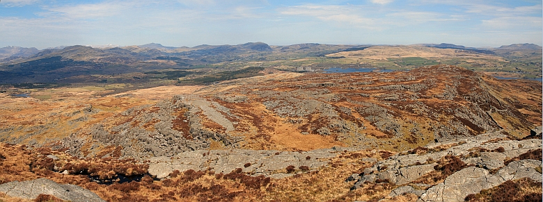
Llyn Trawsfynydd and the Rhinogydd (Photo by Nanuls)
Red Tape and Access
Unlike the national parks of North America and certain parts of Europe, there are no permits required for entry into the Snowdonia National Park, no visitor limits or any other kind of red tape designed to restrict access. Therefore, there are no significant red tape or access issues affecting the Rhinogydd. Since the passing of the Countryside and Rights of Way Act (CRoW) 2000, the public have the right to access almost all the land within the national park boundary regardless of ownership. Open access land is denoted by the signs below.
For climbers, hill walkers and mountaineers, the British Mountaineering Council (BMC) runs a Regional Access Database, which holds mountain/crag specific information on matters of conservation and access, including issues such as nesting restrictions, nature designations and preferred parking:
|


Getting There
The Rhinogydd are located in the Meirionnydd part of the Snowdonia National Park. They are close to the coast and near the towns of Dolgellau, Barmouth and Harlech. By far the easiest way of reaching them is by car and it is fortunate that they are surrounded by good roads that remain open in all but the harshest of winter conditions. The eastern part of the range is the easiest to reach as it can be accessed via the A470 which runs from Dolgellau (SH 728 177) to Conwy (SH 700 459). The west will require a bit more effort, but pays dividends in that this aspect of the range is so much nicer. It can be reached by the A496, which runs along the coast from Llanulltyd (SH 715 194) near Dolgellau(SH 728 177), via Harlech (SH 580 312), to Blaenau Ffestiniog (SH 779 775) in the north. There are good places to park, which either take the form of lay-bys or official car parks, at Graigddu-isaf (SH 684 302), Tyn Twll (SH 685 356), Trawsfynydd (SH711 355), Moel Glo (SH 685 356), Cwm Bychan (SH 646 314), Cwm Nantcol (SH626 259) and Barmouth Slabs (SH 624 166). From these you can access the best the range has to offer. For those without private transport, the area can also be reached by rail or bus, however getting from the stations/bus stops to the mountains themselves can be difficult, as overall, the public transport is pretty infrequent and hitching can be a nightmare. |
Camping and Accommodation
Due to the fact that Snowdonia has been designated a National Park there is an abundance of accommodation available throughout the area. There are numerous campsites surrounding the range. Arguably the best situated, but also the most basic is a campsite at Cwm Bychan (SH 644 313) in the heart of the mountains and in easy distance from both Rhinog Fawr and Rhinog Fach. Other nearby campsites can be found at Cae Gwyn Farm (SH 713 297) to the east of the range, and Merthyr Farm (SH 600 319) to the west. Campsites, hostels, hotels and B&Bs can also be found at all of the larger neaby towns e.g. Porthmadog, Harlech, Dolgellau, and Barmouth; as well as in some smaller villages along the coast e.g. around Dyffryn Ardudwy, Llanbedr and Talybont. For that real wilderness experience, wild camping is by far the best way to stay in the Rhinogydd. To prevent the despoiling of this beautiful area, the following rules should be followed: |

Rhinog Fawr (left) and Rhinog Fach (right) (Photo by Nanuls)
Wild Camping: The Law in England, Scotland and Wales Tents cannot be pitched just anywhere because every piece of Britain is owned by some individual or some organisation and according to the strict letter of the law permission must be obtained prior to pitching tent and camping. In practice however, this is often impractical and wild camping is usually tolerated in the more remote areas - typically, more than half a day's walk from an official campsite or other accommodation providing you:
|
Maps
|
| Navigation Maps Ordnance Survey 1:25k Explorer Series OL 18 Harlech, Porthmadog & Bala/Y Bala Ordnance Survey 1:50k Landranger Series 124 Porthmadog & Dolgellau Harvey Map Services 1:25k Rhinogs/Rhinogydd Harvey Map Services/BMC 1:40k Snowdonia South Road Maps |
Guidebooks
|
|


External Links
 Llyn Morwynion (Photo by Nanuls) Llyn Morwynion (Photo by Nanuls) Llyn Bychan (Photo by Nanuls) Llyn Bychan (Photo by Nanuls) Y Garn (Photo by Nanuls) Y Garn (Photo by Nanuls) Y Llethr (Photo by Nanuls) Y Llethr (Photo by Nanuls)Government Bodies and Official Organisations Snowdonia National Park Authority Association of National Park Authorities Royal Commission on Ancient & Historical Monuments in Wales Hiking, Climbing and Mountaineering Organisations and Companies British Mountaineering Council Plas y Brenin National Mountain Centre Weather Tourist Information North Wales Tourism Partnership Local Information from Gwynedd.com Local Information from Snowdonia Wales Net Travel Welsh Public Transport Information Accommodation Youth Hostel Association in Wales Maps and Guidebooks Cordee Travel and Adventure Sports Bookshop Wildlife and Conservation |