
-
 10496 Hits
-
 72.08% Score
-
 2 Votes
|
|
Route |
|---|---|
|
|
Hiking, Mountaineering |
|
|
Spring, Summer |
|
|
A few days |
|
|
Walk-up |
|
|
Panticosa-Vielha "The Kingdom of Three Thousands"
-Approach: the last stage of GR-11 Trail (II), from Sallent to Panticosa.-Overview: the land of great mountains over nice valleys, a visit to the central Pyrenees.
-Maps: the itinerary goes across the areas of Tena, Ordesa, Bielsa and Benasque.
Stage 14: Panticosa-Bujaruelo
-Time: 6h.-Slope: Ascent: 910m, Descent: 1212m.
-Trailhead: Baños de Panticosa (Ref. Casa de Piedra)
-Night: Bujaruelo (Camping and refuge).
-Route Points: Baños de Panticosa (1640m), ibon-lake of Brazato (2360m), col alto de Brazato (2550m), San Nicolás de Bujaruelo (1338m).
-Difficulty: easy stage.
-Mountains-Landscape: Baciás, Dientes de Batanes, Vignemale.
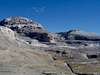
-Commentary: spectacular view of great massif of Vignemale and the great peaks of Ordesa. The climb of Baciás from the col of Brazato is a good option but is long and with a lot of stones. The lakes of Brazato is a good place as well.
 |  |  |  |  |
Stage 15: Bujaruelo-Góriz
-Time: 6h.-Slope: Ascent: 1180m, Descent: 328m.
-Trailhead: San Nicolás de Bujaruelo.
-Night: Refuge of Góriz (Camping allowed).
-Route Points: Bujaruelo (1338m), puente de los Navarros (1060m), Gradas de Soaso (1640m), Cola de Caballo (1760m), ref. Góriz (2195m).
-Difficulty: medium stage.
-Mountains-Landscape: Taillon, Cique de Gavarnie, Astazús, Marboré, Cilindro, M.Perdido, Soum de Ramond.
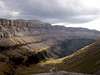
-Commentary: the valley of Ordesa is a lanscape difficult to forget. The approach to village of Torla (3km from Bujaruelo) is a good idea to buy some things. The route of Ordesa's canyon with the nice waterfalls is probably one of the most popular places of the Pyrenees.
 |  |  |  |  |
Stage 16: Góriz-Pineta.
-Time: 6h.-Slope: Ascent: 294m, Descent: 1213m.
-Trailhead: Ref.Góriz.
-Night: Ref.Pineta.
-Route Points: Ref.Góriz (2159m), col Arrablo (2329m), col Añisclo (2453m), Refuge Pineta (1240m).
-Difficulty: easy stage.
-Mountains-Landscape: Punta Custodia, Añisclo’s canyon, Ordesa’s canyon, Punta de las Olas.
-Commentary: a long descent across the valley of Pineta with interesting waterfalls.
 |  |  |
Stage 17: Pineta-Parzán
-Time: 5h.-Slope: Ascent: 910m, Descent: 1006m.
-Trailhead: Ref.Pineta.
-Night: village of Parzán (alternative: village of Bielsa, + 30 min)
-Route Points: Ref.Pineta (1240m), la Larri (1560m), col Piedramula (2150m), Chisagües (1360m), Parzán (1144m).
-Difficulty: easy stage.
-Mountains-Landscape: La Munia, Robiñera.
-Commentary: the view of cirque de la Munia, the valley of Langorrués, valley of river Cinca…excellent landscape.
 |
Stage 18: Parzán-Biadós
-Time: 7h.-Slope: Ascent: 1201m, Descent: 765m.
-Trailhead: village of Parzán.
-Night: ref. Biadós (alternative: free refuge of Tabernés)
-Route Points: Parzán (1144m), Ordiceto’s dam (1940m), pass d’es caballos (2315m), Bordas de Lisier (1760m).
-Difficulty: medium stage.
-Mountains-Landscape: Bachimala, Culfreda, Lustou, Punta Suelza.
-Commentary: alpine aspect for this area with green plains, rocky mountains...
Stage 19: Biadós-Benasque
-Time: 6h30min.-Slope: Ascent: 546m, Descent: 1338m.
-Trailhead: ref. Biadós.
-Night: camping of Senarta near of village of Benasque
Alternatives: Ref. Quillón (free, bad conservation) or Ref.Puente de Coronas (free, good). Ref. Estós (keeped) to divide in 2 stages or the variation GR11-2 to refuge A.Orús near of Posets.
-Route Points: Biadós (1740m), Añes cruces (2080m), Puerto de Chistau (2592m), ref. Estós (1890m), bridge San Jaime (1254m), Senarta-Benasque (1590m), Ref.Quillón (1785m), Ref.Bridge of Coronas (1980m).
-Difficulty: easy stage.
-Mountains-Landscape: Posets, Aneto.
-Commentary: spectacullar view of great mountains.
 |
Stage 20: Benasque-Vielha
-Time: 11h.-Slope: Ascent: 910m, Descent: 1280m.
-Trailhead: Benasque.
-Night: village of Espitau de Vielha.
-Route Points: Senarta (1590m), Ref. Quillón (1785m), Bridge of Coronas
(1980m), Col Ballibierna (2710m), estany d'Anglos (2215m), Espitau de Vielha (1630m).
-Difficulty: hard stage.
-Mountains-Landscape: Ballibierna , Aragüels, Maladeta Massif.
-Commentary: long stage, valley of Salenques, some lakes, great landscape. Probably after 18 stages if you walk from the beginning though many guides make this stages 19 and 20 in this form, it's a good idea the division in 3 stages. Probably a day of rest in the village of Benasque it's a very good option making only the walk to the track of Ballibierna to the Refuge of Puente de Coronas (also called Refugio de Ballibierna).
 |  |
Essential Gear
-Wear: Boots, great haversack, sleeping bag (light), vivacq wraping for an emergency, polar jacket, clean clothes, anorak.-Useful: map (very important), compass, first-aid kit.
-Others: water bottle, frontal flashlight, food, money (for the refuges and food).
Generally the stages go across the refuges each night but you must to think in the things neccesarys to a great trail of 5 weeks