
-
 6757 Hits
-
 87.76% Score
-
 25 Votes
|
|
Mountain/Rock |
|---|---|
|
|
34.00664°N / 116.05674°W |
|
|
Riverside |
|
|
Trad Climbing |
|
|
Spring, Summer, Fall, Winter |
|
|
4000 ft / 1219 m |
|
|
Overview

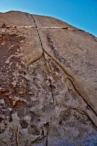
Close up view of The Woodshed
Not to be mistaken with "The Grand Canyon" in Arizona, Grand Canyon is a rock formation in the Split Rocks area of Joshua Tree National Park, California.
Calling the open area between two rather small formations "Grand Canyon" may have been a joke, but it's where the access trail to more popular climbing formations such as Isles In The Sky and Rubicon Rock pass through.
Although not as convolutes as the Echo Rock area, Split Rocks parking lot area offers many rock formations in its vicinity. Outside the immediate neighborhood of Split Rocks itself, Grand Canyon is the closest formation to and clearly visible to the southwest from the parking lot. Considering the richness in formations with moderate difficulty levels closer to the parking lot, it should come as no surprise that Grand Canyon gets minimal attention from Climbers. The northeast face of this rock is steep, may be even overhanging, and except for one climb, all of the routes are difficult.
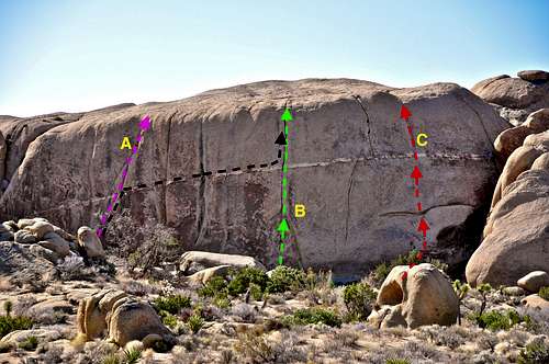
Topo
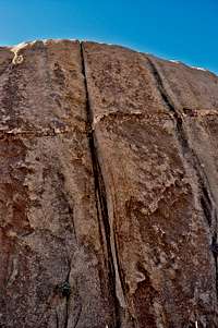
Right side
Besides a number of cracks on the northeast face of Grand Canyon, the most striking feature of this rock is a white dike that runs horizontally across the entire length of this face. The most moderate route on this face is located on the far right side and it's called "Grand Canyon Donkey Trail," rated 10a. This is a face route protected by a mere two bolts. Be forewarned, this route, as in most bolted face routes in Joshua Tree, is badly runout.
The remaining routes are at least a number grade more difficult than "Grand Canyon Donkey Trail. One of the most unusual routes on this rock starts half way up a crack on the left side, Midnight Lumber. Then, it follows the prominent dike climbing and traversing to the right to finish the second half of another crack, The Woodshed, to reach the top. This traverse is rated 12b, R. Again, the letter "R" signifies the lack of adequate protection, only four bolts, for the entire traverse.
List of the routes
select routes of Grand Canyon | |
| A | Midnight Lumber, 10d, 1 bolt, standard rack |
| B | The Woodshed, 11d, bolt, standard rack, many thin pieces |
| C | Garnd Canyon Donkey Trail, 10a, bolts |
| Black line | Every Which Way But Up, 12b, RUNOUT, 4 bolts, thin to medium pro |
Getting There

From the western entrance to Joshua Tree National Park drive on Park Boulevard, formerly known as Quail Springs Road, for about nine miles to a major rock formation called Intersection Rock. Intersection Rock is a major landmark on the north side of Park Boulevard with ample parking for visitors and climbers alike. This rock, true to its name, sit at the cross roads to “Hidden Valley Campground”, Barker Dam Road and the road to “Day use and picnic” area. From Intersection Rock drive another 9.6 miles on Park Boulevard to it’s intersection with Split Rocks Road. Turn left and drive to the end of the road. This is a “Day Use Area” and it’s open from dawn to dusk. Looking in the direction of the southwest, Grand Canyon Rock is clearly visible as a short, but long formation. It is most likely that the climbing face of this rock would be in the shade and a bit dark. Follow the well marked trail for 250 yards to the rock.
Camping, Noise Considerations, Environmental Concerns,
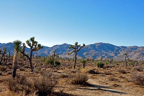
Typical Joshua Tree landscape
Please tread lightly. The Access Fund has gone to great lengths posting trail marker for approaches to many of the more popular crags. Do your best to stay on these trails, and where you are forced to use a different path, choose the ones that rain can mend in time. Drainages make for good trails where there are no established trails.
Avoid stepping on native and fragile plants, and do not feed the coyotes. Coyotes are very much used to people and often hang around picnic areas and camp grounds in hopes of getting a hand out. It’s better to let them live their natural life.
Camping

Joshua Tree Camping
Noise considerations
When you are camping with friends and sitting around the fire, it is easy to forget that there are other people trying to sleep in the nearby campsites. It is important to put yourself in their shoes. Keep the noise and music to a minimum and certainly not too much past 10 p.m. Your neighbors will smile at you in the morning instead of giving you dirty looks.