
|
|
Mountain/Rock |
|---|---|
|
|
54.57189°N / 3.2768°W |
|
|
Cumbria |
|
|
Hiking, Mountaineering, Scrambling |
|
|
Spring, Summer, Fall, Winter |
|
|
2795 ft / 852 m |
|
|
Overview
 Grasmoor
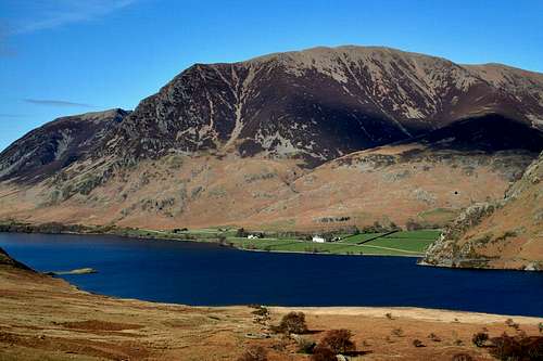
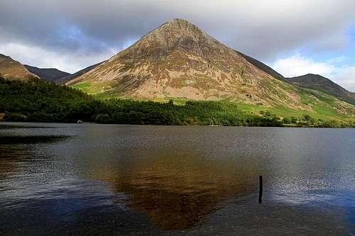
Grasmoor is the highest mountain in the North Western Lakes standing at 852m (2795ft). It has a distinctive outline with steep scree and crags on its western slopes and a broad grassy summit. There are numerous routes of ascent which allows you to summit several other slightly lower mountains in the area. The summit is marked by a large sprawling ancient cairn - this being one of the highest ancient cairns in England.
The mountain has a prominence of 519 m (1,703 ft).
Getting There
Access to Grasmoor can be very easy as the entire North Western Fells is surrounded by road. There are several car parks on the western side of the mountain near the shores of Crummock Water and also a couple of miles to the east near Braithwaite where a longer ascent can be made.To get to The Lake District itself, from the north follow the M6 south past Carlisle and to Penrith. Take the A66 West and you will arrive in Keswick in the North Lakes after about 18 Miles. From the East the best road to take is the A66 across the Pennines to Penrith and then continue to Keswick. From the South you can either take the M6 north to Kendal and then the A591 to Windermere and Ambleside, or continue to get the A66 and then west to Keswick. Of coming from the south east then the A1(m) North is the best route to Scotch Corner and then follow the A66 west to Penrith and then to Keswick.
To get to the car parks on the south western side of the fell follow the signposts to Buttermere from the A66 at Braithwaute about 2 miles west of Keswick.
Red Tape
No red tape.Camping
 The main summit cairn on Grasmoor
External Links
Grasmoor Routes and InformationRoutes
 Map of routes up Grasmoor
Grasmoor can be included in the extremely popular Coledale Horseshoe which covers a range of peaks (Grisedale Pike, Crag Hill, Sail, Scar Crags and Causey Pike) and is a worthwhile addition to the walk. Other less popular routes to the summit are:
Route 1 - Red
From the west side of Grasmoor. Starting at one of the car parks by the shores of Crummock Water this route heads up the small valley of Rannerdale. This valley is famous for its bluebells in spring and was written about by Poet William Wordsworth. From the head of the valley the path heads over the top of Whiteless Pike (which dominates a large portion of the view when you’re in the valley of Rannerdale) and then follows Whiteless Edge north east to the unnamed col between Grasmoor and Crag Hill. From there the path turns west to summit Grasmoor. The descent is usually done via Lad Hows which is a very steep and fairly narrow ridge back to the valley floor.
Route 2 - Blue
This route follows the valley floor of Gasgale Gill up to the top of Coledale Hause and turns south to pick up a path to the unnamed col between Crag Hill and Grasmoor. The normal path west is then taken to the summit. The section along the start of Gasgale Gill involves some short easy scrambling.
Route 3 - Orange
This is the Coledale Horseshoe. Detours can be made from this route before summiting Crag Hill by the normal path to the west from the unnamed col.
Route 4 - Yellow
This is an alternative route to number 2 (blue) - like a 'high level' route. Instead of following the valley the path heads steeply up the side of Whiteside and follows a lovely ridge to the east to the top of Hopegill Head. The ridge is narrow in places but nothing difficult. From Hopegill Head the route heads south to Coledale Hause and then to the unnamed col.
 The west face of Grasmoor