
|
|
Mountain/Rock |
|---|---|
|
|
47.13164°N / 12.73092°E |
|
|
Mountaineering, Skiing |
|
|
Spring, Summer, Fall, Winter |
|
|
11174 ft / 3406 m |
|
|
Overview
The Grosser (big) or Weisser (white) Bärenkopf (Bears head) is a broad firn and rock mountain in between the Bockkarkees glacier and the Bärenkopfkees glacier. The main peak of the mountain is 3406 meter high and the western peak is 3342 meter high. The Grosser Bärenkopf is connected to the Hohe Dock (3348 meter) in the east through the Dockscharte (3234 meter), to the Mittleren Bärenkopf (3357 meter) in the west through the Keilscharte (3194 meter) and to the Klockerin (3422 meter) in the north through the Gruberscharte (3092 meter). From the top you have a nice view on the Grossglockner and the Grosses Wiesbachhorn.In the past the broad north face from the main peak to the west peak of the Grosser Bärenkopf was almost all firn and snow. Nowadays there is a north/north east firn face to the main peak and a north facing firn face to the west peak left. This still leaves enough possibilities for nice ice tours (up to 45 degrees). The easy rock routes up the Grosser Bärenkopf are ideal for an easy ascent or descent. However the rock quality is not superb. It is also worthwhile to combine an ascent of the Grosser Bärenkopf with a visit to the top of the nearby Hohe Dock (approximately 1 hour from the main peak).
The main peak was first climbed in 1869 by K. Hofmann, J. Stüdl, Th. Groder and J. Schnell and the western peak in 1871 by F. Steiner, A. Granögger and G. Bäuerle (source: End and Peterka).
All in al the Grosser Bärenkopf is a nice mountain for some easy ice climbing.
Getting There
 Area map with routes to Grosser Bärenkopf: 1:Oberwalderhütte, 2:Schwarzenberghütte, 3:Grosser Bärenkopf 4:Hohe Dock, 5:Mitterer Bärenkopf, 6:Schwarzköpfl, 7:Klockerin, 8:Vorderer Bärenkopf, 9:Schattseitkopfl, 10:Breitkopf, 11:Fuscherkarkopf
The most obvious routes towards the Grosser Bärenkopf are from the Oberwalderhütte or the Schwarzenberghütte. The various routes from the Oberwalderhütte are coloured red and from the Schwarzenberghütte are coloured blue.
1. Oberwalderhütte (2973 meter)
 Oberwalderhütte
The Oberwalderhütte is a nice and large alpine hutt. It can be most easily reached over the Grossglockner Hochalpenstrasse from either Heiligenblut (south) or from Zell am See (north). The Hochalpenstrasse is a toll road which costs 28 euro for a day and 35 euro for 2 weeks. It is also possible to take a bus from over the toll road which is cheaper.
Drive over the Hochalpenstrasse to the end at the Frans-Josefs-Höhe (2430 meter) where there is free parking space and a restaurant, museum and tourist shops. From there you can walk to the Oberwalderhütte over a trail and a marked snow/glacier route (which is considered safe to go without a rope) in approximately 2.5 hours.
From this hütte there are routes (red) to different sides of the Grosser Bärenkopf which start at the Hütte (2973 meter) and go over the Wasserfallwinkel glacier through the Bockkarscharte (3038 meter) and one route goes over the Bockkarkees glacier to the south side of the Grosser Bärenkopf and the other goes through the Keilscharte (3194 meter) to the Bärenkopkees glacier to the north side of the Grosser Bärenkopf
These routes are over relatively flat and therefore only take from 1 to 1.5 hours. As the routes are over glaciers it is absolutely necessary to use a rope in case you encounter a crevasce.
2. Schwarzenberghütte (2267 meter)
The Schwarzenberghütte is a somewhat smaller hutt. To reach it is best to go to Ferleiten just where the toll road starts (so you don't have to pay the toll fee). There are parking places in Ferleiten but it is also possible to take the bus to it. From Ferleiten a relatively flat path through the valley floor goes to Vogerlalm where it starts to climb up to eventually the hutt and takes approximately 3.5 hours.
From this hütte there are routes (blue) to different sides of the Grosser Bärenkopf which start at the Hütte (2267 meter). One crosses the Hochgruberkees glacier to the Gruberscharte (3092 meter) to the north side of the Grosser Bärenkopf (2.75 hours). Another passes the Remsschartl (2671 meter) on the south side of the Hohe Dock and over the Bockkarkees to reach the south side (approximately 3000 meter) of the Grosser Bärenkopf (2.5 hours). And another goes onto the Hohe Dock (3348 meter) south east ridge (UIAA I) and down the west ridge (UIAA II) into the Dockscharte (3234 meter) to reach the east ridge of the Grosser Bärenkopf (3.75 hours).
These routes from the Schwarzenberghütte ascend almost 1000 meters so require more effort than from the Oberwalderhütte. As the routes are over glaciers it is absolutely necessary to use a rope in case you encounter a crevasce.
3. Gruberscharte Biwakschachtel (3100 meter)
Besides starting out at one of the hutts it is also possible to spend the night in the Biwakbox "Gruberschartenbiwak"" (3100 meter) to the north of the Grosser Bärenkopf (at number 4 in the map below). The box has room for 9 people and should have blankets. It can be reached over the routes from the Oberwalderhütte or the Schwarzenberghütte.
Routes
 Map of Grosser Bärenkopf: 1:Main peak, 2:West peak, 3:Hohe Dock, 4:Gruberscharte (Biwakschachtel), 5:Dockscharte, 6:Keilscharte, 7:Östliches Bärenkopfkees, 8: Westliches Bärenkopfkees, 9:Bockkarkees
a. West ridge (blue) I (1 hour)
b. South ridge (cyan) II (1.25 hour)
c. East ridge (green) 30 degree firn (0.75 hour)
d. South west face (brown) III- (1 hour)
e. North (east) face to main peak (purple) 40 degree firn/ice (1 hour) (ski descent)
f. North face to west peak (red) 45 degree firn/ice (0.75 hour)
g. North ridge to west peak (yellow) II (1.25 hour)
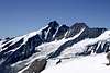
View from the top of the Grosser Bärenkopf


Camping
There are campings in Heiligenblut from which you can reach the Frans-Josefs-Höhe by car:Tourist information Heiligenblut
Nationalpark Camping
Möllfluss-Camping
There is also a camping in Fusch which is close to Ferleiten from where you can walk to the Schwarzenberghütte:
Tourist information Fusch
Camping LampenHäusl
When to climb
The best time to climb the mountain is from from may to september.The best time to ski the mountain is from may to june.
External Links
HüttenOberwalderhütte
Schwarzenberghütte
Campings
Tourist information Fusch
Camping LampenHäusl
Tourist information Heiligenblut
Nationalpark Camping
Möllfluss-Camping
Weather
Glockner region weatherforecast
Heiligenblut weatherforecast
Grossglockner Hochalpenstrasse