Overview
Spielmann (3.027 m) is a prominent rock-pyramid in the Tauern main-ridge.
It belongs to the
Glockner group and is one of the 51 peaks in this group with a height above 3.000 m (it's number 47 in this list).
![Spielmann seen from south-west]() The south-west face of Spielmann seen from
a nameless glacier lake below the notch "Untere Pfandlscharte".
The south-west face of Spielmann seen from
a nameless glacier lake below the notch "Untere Pfandlscharte".
Spielmann rises to the east of the important notch "Untere Pfandlscharte" (2.663 m).
![The notch Untere Pfandlscharte]() Looking to the notch "Untere Pfandlscharte" (2.663 m).
To the left rises "Schartenkopf" (2.861 m) above a nameless glacier lake,
to the right you can see the lower part of the Spielmann west-north-west ridge.
Looking to the notch "Untere Pfandlscharte" (2.663 m).
To the left rises "Schartenkopf" (2.861 m) above a nameless glacier lake,
to the right you can see the lower part of the Spielmann west-north-west ridge.
This notch was already an important crossing of the alps in ancient times. It was as well used by the romans to reach the area of Salzburg.
There is a glacier to the north of Spielmann – the so called "Spielmannkees" (Spielmann-glacier).

To the south-east there are some remains of the former "Guttal"-glacier.
Spielmann has a ridge-connection to the south, to the summit of "Racherin" (3.093 m) and to the east-north-east, to the summit of "Kloben" (2.936 m).
The first ascent of Spielmann was done from locals before 1857.
There is a cross on the summit, dedicated to the victims of mountain-accidents.

Getting There
To reach the various trail-heads you have to use "Grossglockner Hochalpenstrasse", a beautiful panoramic road – in fact the most famous panoramic road in the eastern alps.
For more details refer to the "Getting there" section of the
Brennkogel main-page.
For additional information and nearby huts you can check as well the chapter "Mountain huts" on the SP page
GLOCKNER GROUP of Matthias Zehring and the link
Nationalpark Hohe Tauern
Routes Overview
You can use several routes to reach the summit of Spielmann:
-
West route / WNW-ridge (UIAA: I), app. 3 hours from the hut "Glocknerhaus" (2.132 m) on the panoramic road via the notch "Untere Pfandlscharte" (2.663 m) and the WNW-ridge to the summit


-
Souhwest face (UIAA: I), app. 3 hours from the hut "Glocknerhaus" via the notch "Untere Pfandlscharte" and the SW-face to the summit
-
Souhwest wall (UIAA: II), app. 3.5 hours from the hut "Glocknerhaus" via the notch "Untere Pfandlscharte" and the rocky face to the connecting ridge "Racherin – Spielmann" and continuing on this ridge to the summit
-
Southeast route (UIAA: I), app. 3 hours from the Guttal-bridge (1.940 m) on the panoramic road via the remains of the "Guttal"-glacier up to the highest notch on the northeast-ridge (2.978 m) and to the summit
You can reach the summit of Spielmann as well
-
from the summit of "Racherin" (3.093 m), using the connecting ridge to Spielmann (app. 1.5 hours, UIAA: III) and
")
-
from the summit of "Kloben" (2.936 m), using the connecting ridge to Spielmann (app. 0.5 hours, no climbing difficulties).

There is a summit log and a cross on the summit.
Red Tape
Spielmann is located within the National park "Hohe Tauern"
For the use of the panoramic road "Grossglockner Hochalpenstrasse" you have to pay toll (currently 26,- EUR per car for a single entry).
The road is open from the beginning of may until the end of october (the concrete days are depending on the road-/snow-conditions in spring and autumn).
During the night the road is closed - between 15th of june and 15th of september from 22:00 to 05:00, before and after these dates from 20:30 to 06:00.
The last possible entry is always 45 minutes before the night closure.
For more information check
www.grossglockner.at or use the following phone number: ++43 (0) 65 46 / 650
When To Climb
Best time: July to September, according to the mountain conditions June and October can be fine as well.
Depending on the conditions and your skills the mountain can be climbed throughout the year.
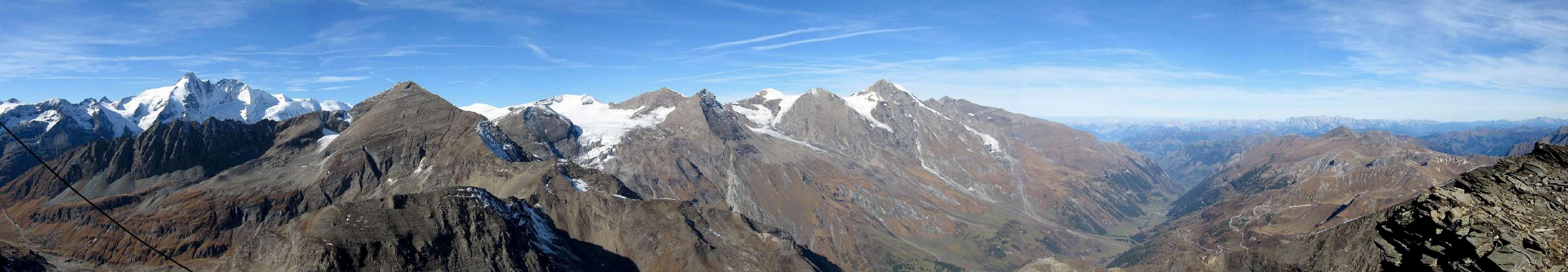
Summit Views
The summit offers breathtaking views to Grossglockner, many other important summits of the Tauern main ridge and impressive views deep down to the valley of "Ferleiten".
Panorama from the summit of Spielmann (southwest to northeast) |
from left to right, mentioning the prominent peaks:
- to the very left: Schwerteck, Kellerskopf, Kellersberg, Hohenwartkopf
- then: Grossglockner and Glocknerwand, Sonnenwelleck (hiding most of Fuscherkarkopf)
- Hohe Riffl, Breitkopf, Mittlerer and Grosser Bärenkopf, Hohe Dock
- Klockerin, Bratschenkopf, Grosses Wiesbachhorn
- Deep down the valley of Ferleiten
- Schwarzkopf, Edelweiss-Spitze
- you can see the panoramic road just left behind the summit-ridge
Some more summit views:


Mountain Huts
The
major base to reach the notch "Untere Pfandlscharte" (which is an important point, where several routes are crossing) is the
Glocknerhaus.
To reach Glocknerhaus you turn to the left at the roundabout app. 4 km after the toll-station (direction "Franz-Josefs-Höhe"). After this you can’t miss it… Glocknerhaus is on the left side of the road, it offers a rather big parking-lot and a National park info point is located there, too.
![The Glocknerhaus]() Glocknerhaus
Glocknerhaus
The Glocknerhaus was built in 1876. It was enhanced several times and renovated between 2000 and 2003.
From here you have a great view to Grossglockner, giving the hut its name.
It is an important starting point for several routes in the Glockner group, e.g. to Spielmann
Glocknerhaus is open between may and october and offers a capacity of 100 sleeping berths.
Phone: ++43 (0) 4824 / 24666
Internet:
www.glocknerhaus.com
www.dasglocknerhaus.at
There are several other huts along the panoramic road, which are useful.
For more information about other nearby huts you can check as well the chapter "Mountain huts" on the SP page GLOCKNER GROUP of Matthias Zehring.
Literature
Map:
Alpenvereinskarte (number 40) "Glockner group" (1:25.000)
ISBN 3-928777-87-4
Book:
"Glockner region" by Walter Mair (including 50 routes in the Glockner region)
As far as I know, this book is only available in german.
In this book you can find a detailed description of the west route to Spielmann.
First edition from 2004.
ISBN 3-7633-4317-2
12,90 EUR
www.rother.de

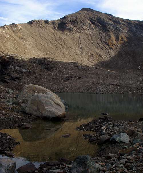 The south-west face of Spielmann seen from
a nameless glacier lake below the notch "Untere Pfandlscharte".
The south-west face of Spielmann seen from
a nameless glacier lake below the notch "Untere Pfandlscharte".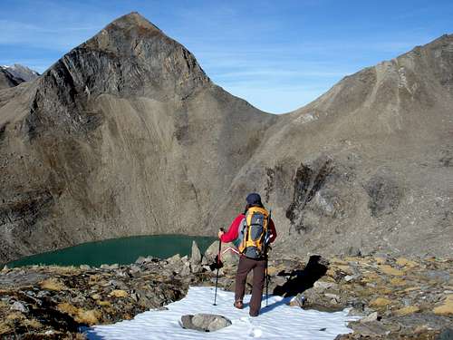 Looking to the notch "Untere Pfandlscharte" (2.663 m).
To the left rises "Schartenkopf" (2.861 m) above a nameless glacier lake,
to the right you can see the lower part of the Spielmann west-north-west ridge.
Looking to the notch "Untere Pfandlscharte" (2.663 m).
To the left rises "Schartenkopf" (2.861 m) above a nameless glacier lake,
to the right you can see the lower part of the Spielmann west-north-west ridge. To the south-east there are some remains of the former "Guttal"-glacier.
Spielmann has a ridge-connection to the south, to the summit of "Racherin" (3.093 m) and to the east-north-east, to the summit of "Kloben" (2.936 m).
The first ascent of Spielmann was done from locals before 1857.
There is a cross on the summit, dedicated to the victims of mountain-accidents.
To the south-east there are some remains of the former "Guttal"-glacier.
Spielmann has a ridge-connection to the south, to the summit of "Racherin" (3.093 m) and to the east-north-east, to the summit of "Kloben" (2.936 m).
The first ascent of Spielmann was done from locals before 1857.
There is a cross on the summit, dedicated to the victims of mountain-accidents.


 - Souhwest face (UIAA: I), app. 3 hours from the hut "Glocknerhaus" via the notch "Untere Pfandlscharte" and the SW-face to the summit
- Souhwest wall (UIAA: II), app. 3.5 hours from the hut "Glocknerhaus" via the notch "Untere Pfandlscharte" and the rocky face to the connecting ridge "Racherin – Spielmann" and continuing on this ridge to the summit
- Southeast route (UIAA: I), app. 3 hours from the Guttal-bridge (1.940 m) on the panoramic road via the remains of the "Guttal"-glacier up to the highest notch on the northeast-ridge (2.978 m) and to the summit
You can reach the summit of Spielmann as well
- from the summit of "Racherin" (3.093 m), using the connecting ridge to Spielmann (app. 1.5 hours, UIAA: III) and
- Souhwest face (UIAA: I), app. 3 hours from the hut "Glocknerhaus" via the notch "Untere Pfandlscharte" and the SW-face to the summit
- Souhwest wall (UIAA: II), app. 3.5 hours from the hut "Glocknerhaus" via the notch "Untere Pfandlscharte" and the rocky face to the connecting ridge "Racherin – Spielmann" and continuing on this ridge to the summit
- Southeast route (UIAA: I), app. 3 hours from the Guttal-bridge (1.940 m) on the panoramic road via the remains of the "Guttal"-glacier up to the highest notch on the northeast-ridge (2.978 m) and to the summit
You can reach the summit of Spielmann as well
- from the summit of "Racherin" (3.093 m), using the connecting ridge to Spielmann (app. 1.5 hours, UIAA: III) and
") - from the summit of "Kloben" (2.936 m), using the connecting ridge to Spielmann (app. 0.5 hours, no climbing difficulties).
- from the summit of "Kloben" (2.936 m), using the connecting ridge to Spielmann (app. 0.5 hours, no climbing difficulties).
 There is a summit log and a cross on the summit.


 Glocknerhaus