The Approach
Spring had arrived in Missouri and with it came the itch to return to the mountains. Sadly, the high peaks of Colorado were still getting pounded with heavy snows, and wet slides and postholing didn't excite me at all!
I looked around for an alternative to the high peaks, somewhere that I hadn't been, and possibly a third state highpoint to add to my list. Harney seemed to meet all of those criteria and offered me a chance to test my new truck on a
long interstate run. At over 7,000' above sea level, it's solidly in the upper third of all state highpoints. However, it looked a lot like Guadalupe Peak in Texas, a 'tweener that would divide the small peaks from the big boys.
Saturday, April 18th, I loaded up and set out for Hill City, South Dakota. The moment I stepped out the door of my Kansas City home, the rain began to pour. I fired up my engine, switched on the windshield wipers, and hit I-29 North to I-90 West. After 11 hours of driving with stops in Sioux City, Kadoka, and Rapid City, I was finally able to shut off my wipers. The last 30 minutes of the trip from Rapid City to Hill City were amazing, the sun broke out, and the scenery changed dramatically.
P.S. Thanks for the 75mph speed limits, South Dakota!
The Ascent
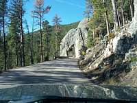
Sunday morning, I awoke in good spirits, not at all crippled from sitting upright the previous day - I'll thank Chevy's manual lumbar adjustment for that! Highway 87 from Hill City to the entrance of Custer State Park is an interesting little road that twists and narrows in places and reminds you that the Black Hills really do have a bit of "mountain" to them. For instance, here's a tunnel carved through the rock on the approach to Sylvan Lake (10' wide and 10' tall, but feels like a snug fit):
The forecast for the day in Custer had temps topping out in the low 60s with clear skies but increasing winds. The night before, it had certainly been down around freezing at the park's elevation, so I figured what little snow was left on the trail wouldn't be an issue. I still decided it would be worthwhile to drag my Yaktrax along, a decision I would benefit from later in the day.
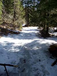
Sylvan Lake Trail #9 is a Class 1 trot up some really simple forest terrain. Navigation was simple once I got past the first fork in the road (hint: stay right/low), especially once I made it to the snow-packed parts of the trail. Trampled by dozens of feet from the week prior, the trail itself was one of the only places on the mountain still holding snow. At first, the hard-pack was fun, but created a few slippery spots further up the trail.
Even at my slow picture-taking pace, I made it to the lookout tower on the summit within an hour and forty-five minutes of leaving the trailhead. Temperatures at the top were relatively chilly, probably in the high 40s, and the wind was beginning to whip up as forecasters predicted.
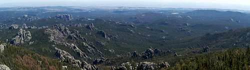
The views from the top of the fire tower were amazing on this clear day. The rectangular bulk of Mount Rushmore's back is an obvious landmark to the northeast, just as Little Devil's Tower sticks out like a sore thumb with the Needles to the south.
The Descent
Following a lunch of two granola bars and some cold water in the protection of the stone fire tower, I set out for the trailhead. I had planned to cut down to Trail #4 and visit the Needles and at least glance at Little Devil's Tower, but I had noticed how sloppy the snow and mud were becoming in the mid-day sun. With this in mind, I decided that it wasn't worth the hassle and I would be better served by heading home on the familar #9 route.
As expected, the warming temps and strong sunshine had really done a number on the snowpack. The threat of slipping on ice was gone, replaced by the threat of sinking and slipping on slushy snow and the puddles of mud created by meltwater. Luckily I had a guide, the footprints of an awesome dog named Dave, whose owner I had met at the summit. Dave was apparently much smarter than my retriever, as he went around the worst spots and found good footing every chance he could. Instead of tromping through puddles, I followed his footsteps and made it back to the parking lot in good time.
Harney Peak, especially this time of year, is a great change-up from the high snow-covered peaks of the West and the dinky foothills of the East, making it a fantastic "Middle Child" of the state highpoints!


Comments
Post a Comment