Part of a Grander Adventure
In July of 2013, my wife and I teamed up with another couple for a journey across the country. Our primary goal was week-long stay at Glacier National Park in Montana, but we planned on a three-night stay in the Black Hills en route. To reduce expenses, we were traveling in our friends' Honda Fit - with four adults and two small dogs. We met up in Cincinnati, where, after enjoying some delicious Cincinnati Chili at Blue-Ash chili, we headed west. We drove through the night across Indiana, Illinois, and into Iowa. Staying off-interstate for much of the trip, we took various US and state highways once we crossed the Mississippi River. I enjoyed seeing Small Town America off the slab. We enjoyed a mom-and-pop burger joint in Platte, SD, and arrived in Custer just before dinnertime. Tired, but happy to be there.
On day one we visited Jewel Cave National Monument and Mount Rushmore National Memorial. I was the only one in the group that had been to the Black Hills before, and although I'd seen Rushmore before, it is always impressive to me in person. I had not been to Jewel Cave before, and our tour was excellent. We took the lantern tour via the Natural Entrance, experiencing the cave in much the same way that tourists did decades ago, before the era of "show caves" with lights and walkways. Our tour guide was a superb blend of informative and humorous, and our group played right into his many jokes. If you're visiting the Black Hills, don't let Jewel Cave slip you by.
Ascending the Peak
![Willow Creek trailhead]() Willow Creek trailhead
Willow Creek trailhead![Formations on Trail #9]() Formations on Trail #9
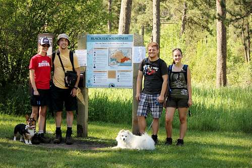
Formations on Trail #9On day two, however, our primary goal was to summit Harney Peak from the more distant Willow Creek Trailhead to the north. Getting to the trailhead is easy - follow SD-244 from Mount Rushmore, and just before you get to the KOA on the right, the road for the trailhead will be on your left. There's a classic brown-and-yellow wooden USFS sign marking the lane. There's plenty of parking, and we piled out of the Fit and prepped for our hike. Ample water - check; dogs on leashes - check; hats and sunscreen - check; trail-mix, apples, and other calorie sources - check. Everyone was in good spirits as the weather was beautiful and it was just one of those days you knew would be perfect for a hike. After filling out the little permit we dropped it in the slot and started up.
![Steeper segment on Trail #9]() Steeper segment on Trail #9
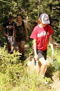
Steeper segment on Trail #9 was the operative word, however. The trail isn't steep by any means, but there's definitely a "more up than down" theme going on. For a majority of the trail the tree cover was good, but pines do have a habit of allowing more sunshine to reach the hiker than would be preferable, so between the exertion and the sun we were definitely feeling the heat. It's important to note for folks following this trail to the summit that from the trailhead you take the "left" branch, which goes back towards the highway and follows SD-244 east for a bit before turning definitively southward towards the peak. Don't get discouraged that your hiking is getting you nowhere. As the de facto trip leader, my comrades simply fell in step behind me, but I had to mentally recall the map to assure myself we weren't going on the wrong trail.
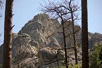
![View of Harney summit]() View of Harney summit
View of Harney summitOnward we marched, the canopy above periodically thinning to allow even more of the sun's heat to warm us. At least once we crossed a small creek, where the dogs could drink and I could wet my hat's brim. The cool water felt wonderful against the heat. About every half hour we'd stop for a drink break, and every hour we'd eat a bit of food. I very much enjoy hiking, and like to maintain a good pace of 2-3 miles per hour, regardless of terrain, but although the dogs were more than happy to charge ahead, my companions were slowing, and our breaks were getting longer. I was a bit worried because the trail was 5 miles each way, and I had expected to summit in under 3 hours. At the rate we were going, 4 hours would be pushing it. It soon became evident that when I said "five miles, 2200 feet of net elevation gain," I was the only one who really understood what that meant. There is a point along trail #9 where you can easily see the fire-tower on top of Harney Peak. Upon seeing it, my companions balked at the distance and vertical required to gain the peak. "Did we start on the wrong mountain?" they asked. Well, no, we hadn't, but the realisation that we still had a long way to go didn't help our pace any.
![View from Trail #9]() View from Trail #9
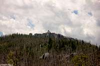
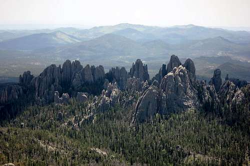
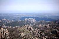
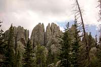
View from Trail #9The one benefit (at least to me) was the lack of other hikers on the route. From the trailhead to the summit we only saw 2 other hiking groups, both on their way down already. This was in stark contrast to reports I got at the summit from the multitudes making the trek from Sylvan Lake. "It was like I-94" one guy said. If you're looking for solitude, Willow Creek is the way to go. And the views aren't bad, either. The trees occasionally break enough to allow for a view of either the summit or of the adjacent Needles (especially at a small saddle around the 6,000' level). Otherwise, you are constantly surrounded by towering pines and unusual rock formations.
After MANY more stops than I would have preferred (of considerable length), we finally reached the summit of Trail #9, where it continues south towards Sylvan Lake. The summit trail is a one-way spur from here, and at this point the traffic increased greatly. There were people everywhere, in stark contrast to the solitude we had just left. We even passed some tied-up horses, which can go almost all the way to summit on the Willow Creek trail. Finally, we ascended the steps to the fire tower and got our view from the top.
![Needles from Harney Peak]() Needles from Harney Peak
Needles from Harney PeakSummit and Down...Have it Your Way.
![Rear of Mount Rushmore]() Rear of Mount Rushmore
Rear of Mount Rushmore![Summit pose]() Summit pose
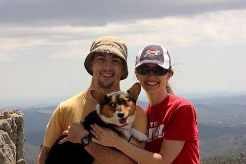
Summit poseMy hiking partners were mostly happy to just sit down for a while, and even the dogs were beginning to tire at this point. There were two other corgis already at the top, to our surprise. I headed up the stairs to the top of the tower to take some photos. The views from the tower really are tremendous. You can see the back of Mount Rushmore from here, and of course the Needles. To the north of the tower are some large boulders, and many of the hikers from Sylvan lake were enjoying a romp on these formations. It became evident, however, that my companions would not be able to return via the Willow Creek trail without great difficulty and time, so we decided that I would return and get the car, while they would hike down to Sylvan lake. Knowing I had a much longer hike and additional drive-time before meeting up with them again, I headed quickly down the trail.
I barely stopped on my way down the trail, content to be able to move at my own pace and stop only as often or as long as I liked. I usually prefer hiking "with" as opposed to alone, but I much prefer that that person have a similar hiking pace to mine. I also wanted to see what sort of time I could set for getting back down the mountain, and although I don't remember what it was specifically, I know it was less than half the time it took us to get to the summit.
![Black Hills Needles]() Black Hills Needles
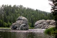
Black Hills Needles![Sylvan Lake]() Sylvan Lake
Sylvan LakeI arrived back at the Fit and began the drive around to Sylvan Lake. SD-87 is a gorgeous road, although traffic was heavy and a lady in a large suburban had no clue what to do about switchbacks. Knowing I was only going to be picking up my friends and then leaving, I skirted past the entry station and avoided paying $5 for nothing. It turns out they had only just come down the trail about 10 minutes prior. The dogs had been much more sluggish as the day wore on, and (in contrast to what I had read in preparation for the trip) the scenery along the trail was actually quite good. In conclusion, I'd recommend the Willow Creek Trail for those interested in solitude, free parking, and a "different" way to bag this highpoint. If you just want to get up and down as quickly as possible, brave the crowds on the Sylvan Lake trail.
Comments
No comments posted yet.