
-
 3251 Hits
-
 73.06% Score
-
 3 Votes
|
|
Route |
|---|---|
|
|
47.08380°N / 11.64310°E |
|
|
Hiking |
|
|
Spring, Summer, Fall |
|
|
Half a day |
|
|
Hike |
|
|
Overview
 Kaserer Winkl Kaserer Winkl |
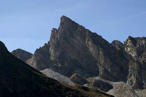
The route through Kaserer Winkl and across Kaserer Scharte is the less trodden path of the two western ascent routes to Frauenwand. Alos, it is the more picturesque of the two, mostly because of the nice views through Kaserer Winkl and towards Schoberspitzen in the west. Moreover, the path between Kaserer Scharte and Frauenwand is a slightly exposed ridge traverse which offers good views towards the neighbouring mountain ranges in the west and north as well as the glacier summits in the east.
Getting There
Follow the "from the north" or "from the south" directions on the main page. At Kasern there is a parking lot at the end of the road and another one at an inn at the mouth of Kaserer Winkl Valley.Route Description
 Große Schoberspitze
- Start altitude: 1610m
- Summit altitude: 2541m
- Prevailing exposure: W
- Type: 3h over marked paths
- Protection: None
From Kasern follow the path #324 to Tuxer Joch (signs. It runs through Kaserer Winkl and passes the inn and a farmhouse close by. Several creeks run down the slopes from each side, all of which have cut deep chutes into the grassy slopes. After a while (20min) you pass a gate after which another 10 minutes lead you to an intersection. The Tuxer Joch trail heads up to the left, but our trail heads straight on.
After another 20 minutes it crosses the Kaserer Bach Creek (actually there are paths on both sides of the creek but the northern ford is much wider than the southern one. Therefore the first 20 minutes should better be hiked on the eastern shore before crossing the creek. After the crossing the marks are hard to find. Generally speaking, you have to follow the creek.
Once you leave the valley floor the trail gets more distinct. and swiftly climbs the lower slopes of Kleiner Kaserer. There is an intersection with the right hand path leading to Kleegrubenscharte while the leftern trail leads to Kaserer Scharte and Herrensteig. At this intersection there is a third path which also leads to Kaserer Scharte but which is less distinct. The two trails recombine after about 1km and finally climb to the saddle.
From Kaserer Scharte a ridge trail leads directly to Frauenwand. It actually stays on the eastern side of the ridge and passes the summit block. You have to descend a couple of meters before you reach the final trail to the Frauenwand summit.