Overview
![Frauenwand]() Frauenwand summit block as seen from the south Frauenwand summit block as seen from the south |
This is what you undoubtedly will have to think if you come up to the pair of Weiße Wand and Frauenwand at the northernmost end of the Tux Main Ridge in the
Zillertal Alps from its western side. Here the Schmirn Valley, which separates the Tux Alps from the Zillertal Alps, leads deep into the mountains, with the picturesque and tranquil village of Kasern at its end. Several paths lead up into both ranges but the most popular is the one to Tuxer Joch, also on the separating line between the two mountain ranges. The path is quiet but for occasional mountain bikers who push rather than ride their machines down the steep and very winding trail.
But come up to Tuxer Joch, the saddle between Olperer and Lizumer Reckner, the two highest mountains of their respective ranges and the world changes abruptly. Suddenly you are in the middle of the ski resort of Hintertux and at one glance you see about 15 ski lifts or cable-cars, all serving the summer ski runs on the slopes of Olperer and Gefrorene Wand.
Right to the west of this ski area, some 500m south of Tuxer Joch you find the summit of Frauenwand together with its sister summit Weiße Wand. Both are rather popular in summer, especially among the hikers who come up from Hintertux with the help of the lifts. Thanks to their position among the high mountains all around the two summits offer great views into that ski area but also across the Brenner Valley towards the central and northern
Stubai Alps. And make no mistake: only the 500m between the saddle and the summit is crowded - if you head onwards to Kaserer Scharte you will soon be alone among the rocks and even the ski lifts will be hidden from your sights.
Apart from the ski lift route Frauenwand has two routes, both leading up from Kasern through the Kaserer Winkl Valley. The one across Tuxer Joch is the more popular but the more picturesque and enjoyable one is the one through Kaserer Scharte in the south. Here you follow the whole valley and climb the lower slopes of Kleiner Kaserer with Frauenwand on one side and the wild Schoberspitzen summit on the other. Once in Kaserer Scharte you follow a slightly exposed trail, Herrensteig, which directly leads to the base of the Frauenwand summit block.
Summit Views
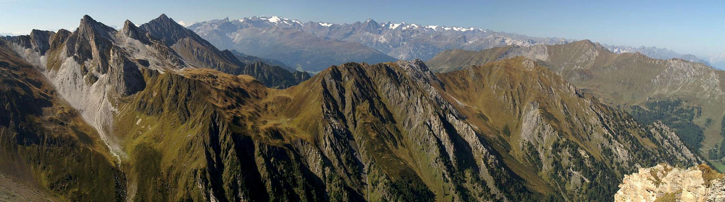
Summit View Frauenwand: Schoberspitzen, Hohe Warte in front of the Stubai Alps |
Frauenwand is a perfect lookout peak, even if you see so many ski lifts. You can see as far as Wettersteingebirge and Zugspitze with the Stubai Alps to the west. The real show, however is the closeup view of all the glaciers around Olperer, Hoher Riffler and Gefrorene Wand.
Getting There
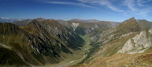
![Kaserer Winkl]() Kaserer Winkl seen from Frauenwand
Kaserer Winkl seen from Frauenwand- From the north
From the Brenner Motorway take the exit Matrei and take B182 south. After Stafflach turn onto the road into Schmirntal (east) which ends at Kasern
- From the south
Leave the Brenner Motorway at Brenner Pass. Take B182 north until you reach Stafflach. Just before the village take the road east into Schmirntal.
- From The east
Leave Inntalautobahn (A12) at Straß and take B169 south. The road leads to Mayrhofen where you need to leave for a side road to Tux and Hintertux. At the end of that road you are at the base of the Tux ski resort.
Red Tape
![Summit Fiew Frauenwand. Riffler Group and Rastkogel Group. Weiße Wand up front]() Grubenkopf Group and Hoher Riffler
Grubenkopf Group and Hoher Riffler
There is no red tape here. Much of the area is used for skiing all year round and it is quite obvious. The western slopes of Frauenwand, however, are quite untouched (as untouched as any area in the Alps) and you can still find beautiful flowers here. Also the Kaserer Winkl Valley is used for cattle grazing so any gates should be kept closed.
Accommodation
Weather Conditions
Maps & Books
Maps
- Digital Maps
- Regular Maps
- Zillertaler Alpen / Tuxer Alpen
Kompass Map WK37
1:50000
ISBN: 3-85491-042 - 8
- Sterzing / Vipiteno
Kompass Map WK44
1:50000
ISBN: 3-85491-050-9
- Innsbruck / Brenner
Kompass Map WK36
1:50000
ISBN: 3-85491-040-1
Books
- Zillertaler Alpen
H. Klier / W. Klier
Alpenvereinsführer
Rother Verlag
ISBN: 3-7633-1269-2
- Zillertal
W. Klier
Rother Verlag
ISBN: 3-7633-4175-7
- Stubai - Wipptal
W. Klier
Rother Verlag
ISBN: 3-7633-4172-2

 8512 Hits
 87.76% Score
 25 Votes
 Frauenwand summit block as seen from the south


 Kaserer Winkl seen from Frauenwand
 Grubenkopf Group and Hoher Riffler