
-
 23485 Hits
-
 96.63% Score
-
 61 Votes
|
|
Mountain/Rock |
|---|---|
|
|
37.74907°N / 105.53287°W |
|
|
Hiking |
|
|
Spring, Summer, Fall, Winter |
|
|
8691 ft / 2649 m |
|
|
Overview
High Dune, in Great Sand Dunes National Park and Preserve, provides the most common hiking experience for visitors to the park.
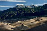
While High Dune is hardly a mountain, it is a summit that clearly stands out from the surrounding terrain. It can also be a great experience for younger children, who might otherwise not get to go "climbing" with mom or dad. It does require a bit of knowledge and planning to safely climb. So, with this "mountain" page I hope to provide this information to those who might be interested in the challenge, and a place for those who might wish to sign the climber's log. Though it is neither the highest dune in elevation nor the tallest, it looks that way from the visitor center. It is about 650 feet (198 meters) high (that can vary slightly over time; this is wind-blow sand, after all!). The 360 degree panoramic view from the top is inspirational. You'll not only see the vast extent of the sand dune complex (most of which cannot be seen unless a hike is taken from the main road), but you'll also be able to see much of the northern range of the Sangre de Cristo Mountains.
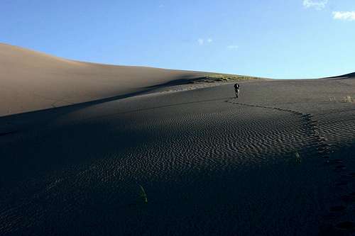 Hiking to High Dune.
Getting There

High Dune is located in Great Sand Dunes National Park and Preserve. Because these are sand dunes, hikers are free to make their own way to the top following any ridgelines they might chose. The most common starting points are: The visitor center. You'll see High Dune directly out the rear exit/patio area of the visitor center. Hike across the sand flat until you reach the base of the dune ridgeline, then zig-zag your way to the top. The sand dune parking lot/dunes picnic area. Take the road to the left about 1/4 mile past the visitor center. Park your vehicle and look for the paths through the brush around the edge of the parking lot. You should easily see High Dune; pick your path and start hiking towards it. The Pinyon Flats Campground. The trailhead is located near campsite #34. Hike until you reach the sand flats. From here you can either head up the gently sloping ridgeline to the peak of High Dune, or you can strike out straight across the sand flats to the base of High Dune (across from the sand dune parking lot),

then hike from there as if hiking from the sand dune parking lot. If you chose the former route to the top, the latter may prove a good return because it offers steeper slopes and a much quicker descent. Once you've crossed the sand flat and Medano Creek (which is dry in late summer), zig-zag across the dunes until you reach the summit of High Dune. Some of the dune slopes can be quite steep, so you'll quickly pick out ridgelines that take you toward High Dune at an acceptable rate of climb. The sand itself is a burden, because it tends to make it quite difficult to walk. Compounded with the altitude (the visitor center is at 8175 ft/2492 m), this hike may turn into more of a challenge than one might anticipate! Expect to take about 45 minutes to an hour to complete the 1.15 mile/1.9 km hike (from the sand dune parking lot) to the top of High Dune. Fortunately, the return trip is much easier: Generally hike straight down any of the dunes. Or, many folks will slide down the dunes on a sandboard, or any make-shift piece of something that will do. Or you could just roll down the dunes like a rolling pin. What fun! Expect your descent to take about 15 minutes.
Hiking Hints and Suggestions
1. Best time to hike is early in the day, the earlier the better. Not only will sand temperatures be more moderate, but the low angle of the sun grazing the dunes and surrounding mountains will make for very dramatic photography. In addition, the ever-present wind will have erased most of the footprints from the previous day's hikers; it pays to be first in the sandbox! Hiking late in the day to enjoy the sunset from the top of High Dune is another excellent option. You'll be at a disadvantage because many footprints will be present, but you should still find it possible to take that "special shot unmarred by human trespass".
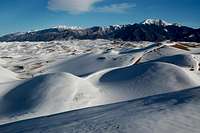
It's also permissible to hike the dunes at night, but a free permit is required (obtain at the visitor center during business hours). Of course, hiking during the winter months should see far fewer people on the dunes, and could present some interesting photo opportunities with the snow-covered mountains.
2. Don't underestimate the difficulty of this hike. While it's not going to be a challenge for an experienced mountaineer, it still requires carrying sufficient water and wearing appropriate footwear (close-toed shoes). That said, however, hiking in the early morning, before the sun has heated the sand to over 140°, can be done bare-footed (though it would be a good idea to carry footwear to donn just in case nearby Star Dune beckons and you decide the extra two or three hours is worth the additional hike!).
3. Although you shouldn't ever be where you lose sight of the visitor center for more than a moment during the entire hike, if you still want to take a map you can have excellent area coverage with the Trails Illustrated® map number 138 (Sangre de Cristo Mountains, Great Sand Dunes National Park & Preserve).
4. Keep an eye, or possibly a toe, out for fulgurites. Fulgurites are tubes of sand welded together by lightning. They're hollow, with an inner surface of glass and an outer coating of sand grains. They vary in size, and often preserve the branching of the electrical stroke. They're very cool to find, but it's a national park of course, so leave them be (Thanks to jfrishmaniii for this info).

5. The top can be much windier than the bottom of the dune field. Take a light jacket, even for hikes in warm weather. And the sand will get into everything, so take extra precautions with sensitive camera gear (Zip-Loc® bags can be quite handy!).
6. Hike with your dog! NPS rules do require that the dog be on a leash, however.
7. Scattered here and there among the dunes are small plants clinging tenaciously to the soil. Don't disturb them.
8. Keep an eye on the weather. This area is just as subject to rapidly changing mountain weather as the adjacent Sangre de Cristo's. If storms start moving in, rapidly retreat to a safe place; you do not want to be along the dune ridgeline during lightning!
9. There are free, outdoor showers at the restrooms at the sand dune parking lot/dunes picnic area.
Red Tape
High Dune is located in Great Sand Dunes National Park and Preserve, so National Park Service fees will apply (currently $3/person over 16 years old). Free permits are required if backcountry camping, and for hiking the dunes at night (obtain at the visitor center during business hours).
Camping, Lodging and Other Services
High Dune is easily accessible from the Pinyon Flats Campground located in Great Sand Dunes National Park and Preserve. The trailhead is located near campsite number 33. Backcountry camping is permitted in the dune field outside the day use area. A free permit is required for backcountry camping (available at the visitor center, 719-378-6399, during business hours).

There is tent and RV camping at adjacent San Luis State Wildlife Area (719-378-2020). The Great Sand Dunes Oasis (719-378-2222), near the park entrance, provides a convenient place for a hot meal and a nice view of the dunes. It also has tent and RV sites, cabins, motel rooms, hot showers, and a laundry. For more luxurious accomodations near by, check out the Great Sand Dunes Lodge (719-378-2900). The nearest large town is Alamoosa, located 34 miles away. It has the requisite Wal-Mart, as well as many other businesses.
External Links
o Official NPS Great Sand Dunes National Park and Preserve Website Lots of general info on the park.
o National Park Service Maps of Great Sand Dunes National Park and Preserve Direct link to maps at the NPS website.
o Wikipedia Great Sand Dunes National Park and Preserve Entry Learn more about Great Sand Dunes National Park and Preserve.
o Wikipedia Fulgurite Entry Learn about these fascinating phenomenon.
o San Luis State Wildlife Area Website Lots of info on this state park adjacent to Great Sand Dunes National Park and Preserve.
o Great Sand Dunes Oasis Restaurant, tent/RV sites, cabins and motel rooms. Also has hot showers and a laundry.
o Great Sand Dunes Lodge Another nearby place to spend the night.