
-
 5007 Hits
-
 78.27% Score
-
 9 Votes
|
|
Mountain/Rock |
|---|---|
|
|
46.71256°N / 10.60198°E |
|
|
Hiking |
|
|
Spring, Summer, Fall |
|
|
8507 ft / 2593 m |
|
|
Overview
 Ortler high above Vinschgau valley (01-11-2007)
The souther Ötztal ranges are quite unknown but are bearing inumerable summits for hikers who love the loneliness and quite a rough and pristine environment.
Hochjoch or equally named Hohes Joch, Giogo Alto, is part of the Planeil mountains which are grouped around Planeil valley and the village of Planeil in Alto Adige / Südtirol. It is one of the southernmost summits of a long ridge, starting from Weißkugel, one of the most prominent Ötztal summits and bearing peaks like (from north to south) Bärenbartkogel, Freibrunner Spitz, Rabenkopf, Valvelspitzen, Gawelzspitze, Pleresspitze, Portlesspitze and Jafaut (or Jafant). All those peaks are rarely summited, mostly by the nearby inhabitants of the surrounding valleys. They are quite remote, some are without marked trails but the whole range has its own pristine beauty.
Hochjoch, an easy and more close summit, is near the southern end of a broad meadow ridge, which starts at Jafaut and ends at Spitzing Lun and Niederjoch.
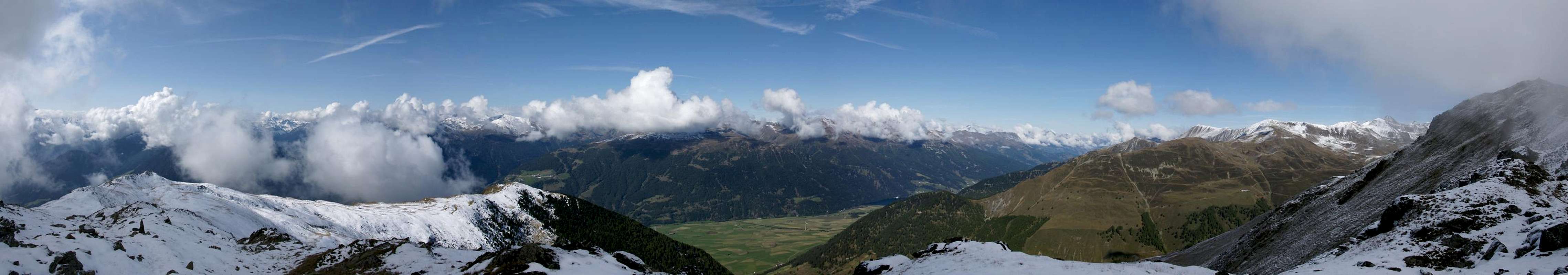
Panoramic View
  |
Getting There
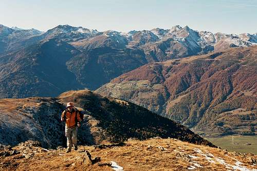 Approaching the summit (01-11-2007)
You can start to Hochjoch from several adjacent valley villages, all of which are approachable by the main road number 40, Meran - Reschenpass / Passo Resia.
You can start hiking from Mals or Schluderns out of the upper Vinschgau valley, although those hikes are very long due to an altitude difference of more than 1600 meters.
Better you start from Planeil or from Matsch.
You reach Planeil (1579 m) using the road number 103 from Mals or from Sankt Valentin auf der Heide (near Reschenpass). There is a parking area near the village entrance.
You reach Matsch (1576 m) via road number 105 from Tartsch between Mals and Schluderns. A parking area for hikers is lokated at the village entrance.
There are many hotels and Bead & Breakfasts in the upper Vinschgau valley, you shurely will find a place to stay.
Red Tape
 Weißkugel / Ötztal Alps and Hochjoch (center right)(01-11-2007)
None, as far as I´m informed
Recommended Route
I would like to recommend a simple and lovely hike I did in late autumn 2007:Starting point is Matsch / Mazia, hikers parking area. Enter the village and turn left on the first road, leaving the village up the mountains. Follow a forest road, number 13 and 15a up some switchbacks until the numbers 13 and 15a divide. Follow number 13, a steep trail, up to Plantavilles at the timberline.
Number 13 now traverses the southern slopes of Niederjoch up to Spitzige Lun (2324 m) a very fine lookout. There are awesome views of the Ortler mountains all the time.
At Spitzige Lun follow the marked trail number 15 along the meadow ridge up to Niederjoch (2474 m) and to Hochjoch (2593 m).
There is a huge cairn marking the summit.
 |  |  |
After a well-deserved break follow the broad ridge in northern direction to Jafaut. Orientation is quite difficult because the trail is barely visible and scarcely marked. It descends slowly, changing on the western slopes of the ridge after a while, traverses it in northern direction and then descends even steeper down to Gondahütte (1997 m).
From Gondahütte use the forest road 15 - 16 back to Matsch in southern direction.
External Links
Matsch InfoChurburg at Schluderns, a great castle to visit
Maps and Books
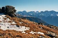
 Saldur range (01-11-2007)
The best map is:
Tabacco, topographische Wanderkarte 1 . 25.000, Blatt 044, Vinschgau / Sesvenna and Blatt 043, Vinschgauer Oberland. You will get them in nearly every bookshop or supermarked.
Some of the summits mentioned above are described in:
Walter Klier, Ötztaler Alpen, Alpenvereinsführer, Bergverlag R. Rother.
Hochjoch is not among them !