
-
 6241 Hits
-
 84.82% Score
-
 19 Votes
|
|
Mountain/Rock |
|---|---|
|
|
46.70642°N / 10.57781°E |
|
|
Hiking, Skiing |
|
|
Spring, Summer, Fall, Winter |
|
|
7625 ft / 2324 m |
|
|
Overview
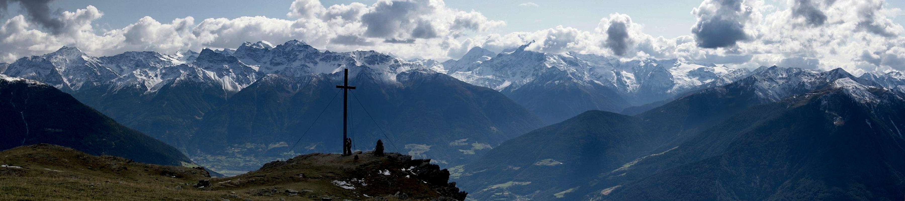
 The summit of Spitzige Lun / Piz Lun in front of the Ortler Group The summit of Spitzige Lun / Piz Lun in front of the Ortler Group |
In the north of Italy, close to both the Austrian and Swiss borders you find the valley of the Etsch / Adige River, called Vinschgau (German) or Val Venosta (Italian). It is one of the largest and most profound valley of the Alps, starting at 230m at Meran / Merano and ending at 1500m at Reschenpass / Passo di Resia. At the same time some 60 3000ers rise along its flanks, some of them almost directly. After two thirds of its length the east-west running valley bends northward and at this point you can find a bunch of perfect lookout mountains, all located at the ends of long ridges. These mountains are between 2300m and 2600m tall and more or less easy to reach. None of them requires any difficult climbing but the elevation difference and length of access makes any climb a formidable daytour.
One of the most popular of these mountains is Spitzige Lun / Piz Lun, a round topped mountain at the end of the eastern ridge of the Planeiler Berge subgroup of the Ötztal Alps. It rises about 1200m above the village of Mals / Malles and only its very top lies above the timberline. Consequently the climb of the mountain for most of its part runs across the dense forests along its slopes which obscur the views for most of the way. There are several routes onto the mountain, either starting at Mals / Malles, Planeil / Planol or Matsch / Mazia to the west, north or east of the mountain.
|


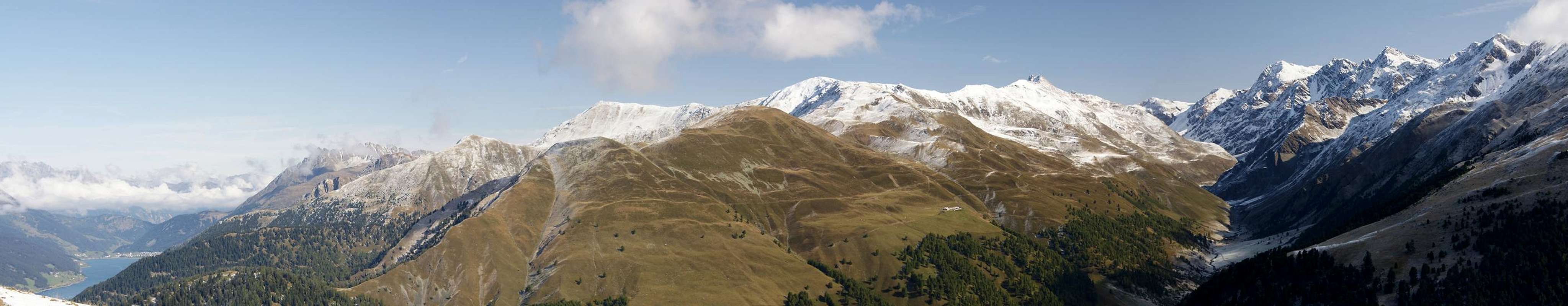
Spitzige Lun is the starting point of a long and easy ridge traverse, which after climbing Niederjoch and Hochjoch leads to the summit of Jafant (Jafaunt). There the easy part ends and the higher and more difficult summits of the Planeiler Berge Group follow. The ridge is famous mostly for the fabulous views it offers towards the Saldurkamm Ridge to the east, one of the least accessible subgroups of the Ötztal Alps.
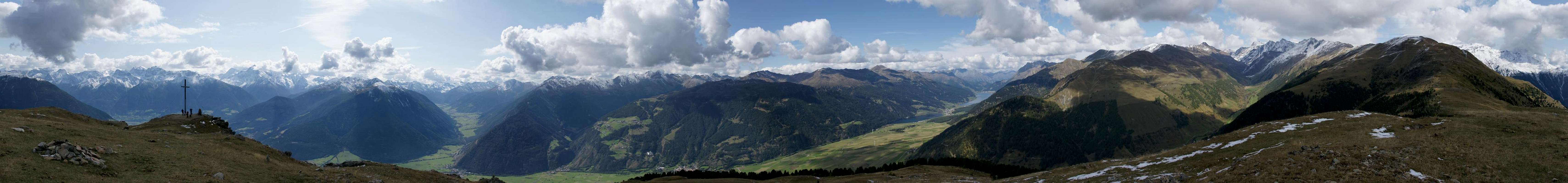
Speaking of views, Spitzige Lun offers a near perfect 360° panorama. The Ortler Group to the south, the Sesvenna Group to the east and the Ötztal Alps to the north and east make up the mountainous lot but the best views are down and across the Vinschgau Valley / Val Venosta. Thanks to its location east of the northward bend of the valley and thanks to the fact that several side valleys open out into it right next to this bend, the mountain awards a very good overview over the ridgelines of the area as you can see from the 360° panorama below.
As for the name - Spitzige Lun is a corruption of the romanic name Piz Lun. This, quite obviously stands for "Mountain of the Moon".
360° Summit Panorama
  |
Getting There
 Spitzige Lun / Piz Lun above the mouth of Planeiltal / Valle del Planol
There are several trailheads for the climb of Spitzige Lun, all around Mals / Malles, the centre of Obervinschgau / Val Venosta Alta. the northern trailhead is at Planeil / Planol, thw western one at Mals / Malles itself, the eastern on at Matsch/ Mazia and the southern and closest one at Muntaschinig. All trailheads are within 4km from Mals.
From Austria
Take B180 from Landeck, which at the border turns into SS40. It runs right through Mals / Malles. The villages, in which you can find the other trailheads can be found easily by following the road signs.
From Italy
Take SS38 from Bozen / Bolzano and Meran / Merano to Spondinig / Spondigna. Here switch to SS40 which will take you to Mals / Males after a few km.
From Switzerland
Take B28 across Ofenpass / Pass dal Fuorn and through Münstertal / Val Müstair. At the border it turns into SS41 to Glurns / Glorenza. There turn northward onto a narrow side road to Mals / Malles.
Red Tape
 |
There is no red tape to speak of. To reach the summit you'll have to cross several meadows, soome of which are private property. The regular hiking trails cross these places and in case of gates barring the way you are requested to close them after you have passed.
Accommodation
 |
Weather Conditions
Maps & Books
 The summit of Spitzige Lun / Piz Lun as seen from Niederjoch / Giogo Basso
Maps
- Vinschgau / Val Venosta
Kompass Map WK52
1:50000
ISBN: 978-3-85491-058-9
- Alta Val Venosta / Vinschgauer Oberland
Tabacco Map 43
1:25000
Books
- Ötztaler Alpen
W. Klier
Alpenvereinsführer
Rother Verlag
ISBN: 3-7633-1123-8
- Vinschgau
Rother Wanderführer
Rother Verlag
ISBN: 978-3-7633-4204-1
- Vinschgau / Ortlergruppe
Kompass Wanderbuch 950
Kompass Verlag
ISBN: 3-87051-404-3