
|
|
Area/Range |
|---|---|
|
|
47.81440°N / 16.00220°E |
|
|
Hiking, Trad Climbing, Sport Climbing, Toprope, Via Ferrata |
|
|
Spring, Summer, Fall, Winter |
|
|
3714 ft / 1132 m |
|
|
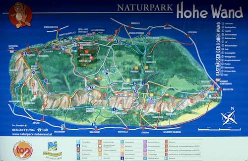
Overview
Hohe Wand as part of the Gutensteiner Alpen are a part of the Northern Limestone Alps
The highest elevation at Hohe Wand is Plackles (1132m) - for climbers IMHO not interesting.
Hohe Wand offers hundreds of climbing routes (from easy to extreme) on its east side, but also some viae ferratae and easy hiking trails. Hohe Wand is therefore an important recreational area for the inhabitants of Vienna and Southern Lower Austria.
Also visitors from Hungary and Slovakia climb at Hohe Wand (I personally met a climbing party from Munich - they preferred the less crowded Lower Austria to the Lago di Garda area)
 Hohe Wand Hohe Wand |
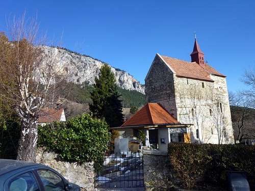 northern part of Hohe Wand and church in Maiersdorf northern part of Hohe Wand and church in Maiersdorf |
|---|
Between Maiersdorf and Stollhof starts a toll road, that leads to to plateau of Hohe Wand, to several huts, hotels, paragliding starting strips, wild animal parks etc.
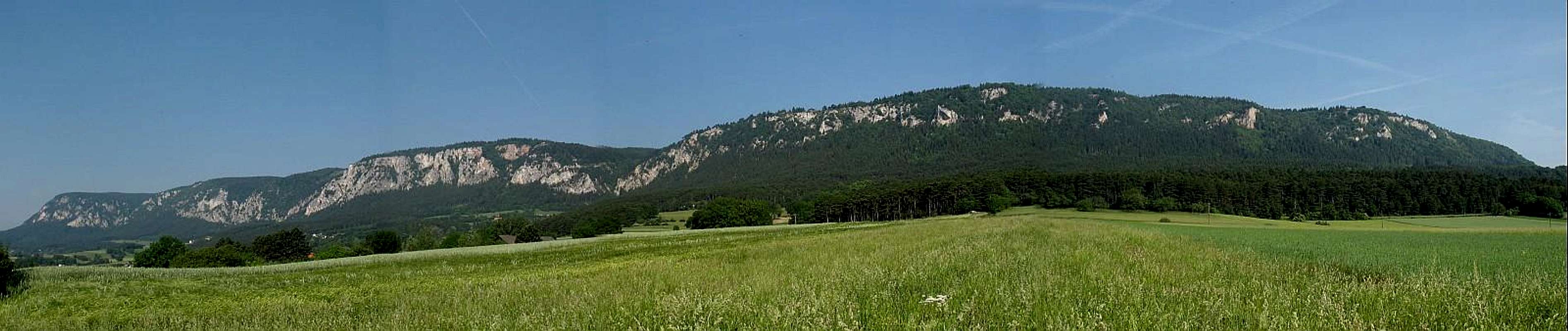  far left Hohe Kanzel - toll road from near the graben (middle) May 2005 |
 northern part of Hohe Wand from Maiersdorf northern part of Hohe Wand from Maiersdorf |
|---|
Important natural parks
 Alpine Ibex Alpine Ibex |
 Lime Kiln Lime Kiln |
 Alpine Chamois Alpine Chamois |
|---|
Getting There
by public transport
The southern part of Hohe Wand (areas around Große Kanzel and Wildenauersteig can be reached from Grünbach am Schneeberg (or Unterhöflein) by train (Austrian Southern Railway change at Wiener Neustadt to Schneebergbahn).
There might be buses to reach the northern part of Hohe Wand (Sorry no further information)
by car
Form Vienna on the highway (Südautobahn - A1)
- to Wöllersdorf (for the northern part) continue Markt Piesting turn left to Dreistetten, via Muthmanndorf to Stollhof
- to Wiener Neustadt West (for the southern part) continue via Weikersdorf, Gerasdorf to Unterhöflein to Maiersdorf or Grünbach
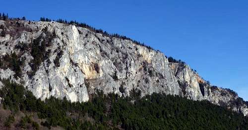
Climbing - Climbing Sectors (South of the Toll Road)
see the link section for more information
important climbing sectors starting at the south end of Hohe Wand
Große Kanzel
Fredsteig, Wienersteig, Kanzelsteig, Naglplatten
 Große Kanzel Große Kanzel |
 Große Kanzel Große Kanzel |
 Fredsteig - Gr. Kanzel Fredsteig - Gr. Kanzel |
|---|---|---|
 Kanzelsteig Kanzelsteig |
 Fredsteig - near Frednase Fredsteig - near Frednase |
 Fredsteig Fredsteig |
Weningerturm
Baumgartnerturm
(near Wildenauersteig)
 Baumgartner Turm Baumgartner Turm |
|---|
Hochfallwand
 Hochfallwand Hochfallwand |
 Auf Wildenauers Spuren Auf Wildenauers Spuren |
|---|---|
 Leitergrabengrat Leitergrabengrat |
Hamburgerpfeiler - Tirolergrat
 Hamburgerpfeiler Hamburgerpfeiler |
 Tirolersteig Tirolersteig |
 Schwarzgrabenkante Schwarzgrabenkante |
|---|
MILAK Klettergarten
Sonnenuhrwand
 Puzzle für Fortgeschrittene Puzzle für Fortgeschrittene |
|---|
Totenköpfel
 Totenköpfl Totenköpfl |
|---|
Draschgrat
 Betty & Paul Betty & Paul |
 Hochempor Verschneidung Hochempor Verschneidung |
|---|---|
 Duettsteig (leads to Draschgrat) Duettsteig (leads to Draschgrat) |
 Draschgrat Draschgrat |
Fuchslochturm
sorry no image
Almfrieden
sorry no image
Climbing - Climbing Sectors (North of the Toll Road)
Teufelsgrat
 Teufelsgrat Teufelsgrat |
 Kletterbrüderpfad Kletterbrüderpfad |
|---|
Wandeck
sorry no image
Viae Ferratae
Viae Ferratae at Hohe Wand range from easy to very hard ones:
- Wagnersteig
- Völlerin
- Springlessteig
- Leiterlsteig
- Naturfreundesteig - this via ferrata is on the west side of Hohe Wan
- ÖGV Klettersteig
- Frauenluckensteig
- Steirerspur
- Wildenauersteig - a very old classic via ferrata
- ÖTK Klettersteig (former HTL Klettersteig - Klettersteig - is open again
- Blutspur - Klettersteig - the most difficult (but very short) via ferrata (and some meters to climb) at Hohe Wand
- Kleine Klause
- Gr. Klause
 Steirerspur Steirerspur |
 Steirerspur Steirerspur |
|
|---|---|---|
 Wildenauersteig Wildenauersteig |
 Wildenauersteig in winter Wildenauersteig in winter |
 Wildenauersteig Wildenauersteig |
 HTL Steig - first part HTL Steig - first part |
 HTL Steig HTL Steig |
 HTL Steig (final part) HTL Steig (final part) |
 Währingersteig in Winter Währingersteig in Winter |
 Kl. Klause Kl. Klause |
Hiking
a lot of marked trails - caution: some are very exposed
|
Lime Kiln |
 European Black Pine European Black Pine |
|---|---|
 unkown flower unkown flower |
 Meadow Meadow |
Caves, Mountain Biking, Paragliding + Hang Gliding
Caves
near Hohe Wand around Dreistetten is Einhornhöhle (show cave) - discovered in 1927, opened in 1930
Mountain biking:
sorry no information
Paragliding + Hanggliding
Two starting strips near Gasthof Postl and one (new) starting strip near Gasthof Almfrieden
 Paraglider Paraglider |
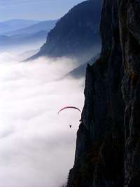 Paraglider at Hohe Wand Paraglider at Hohe Wand |
|---|
Red Tape
no red tape -
Hohe Wand road is a Toll Road on Saturday and Sunday.
Accommodation (B&Bs and huts)
Several huts and B&Bs on the Hohe Wand plateau (e.g. Hubertushaus, Gasthaus Postl etc.) and in nearby towns
Near the tollgate is a new campsite (open from April to October)
 Wilhelm Eichert Hütte Wilhelm Eichert Hütte |
 Turmsteighütte Turmsteighütte |
|---|---|
 Hubertushaus Hubertushaus |
 Hubertushaus in winter Hubertushaus in winter |
 Herrgottschnitzerhaus Herrgottschnitzerhaus |
 Waldeggerhaus Waldeggerhaus |
Books, Maps, External Links, Webcams
Guide Books
- Führer auf die Hohe Wand by Thomas Behm
- Sportkletterführer Hohe Wand by Thomas Behm
- Genußkletteratlas Österreich Band 1 (Niederösterreich) by Kurt Schall etc.
- Bergwanderatlas Niederösterreich (Niederösterreich) by Adi Mokrejs, Brigitte Jirku
(Hiking Guide Book)
all books in German
Maps
detailed map online: Austrian Map Online
Climbing, Viae Ferratae
www.bergsteigen.at offers a lot of climbing, viae ferratae information (only in German)
Webcams
Other Links:
several B+Bs, huts
Paragliding starting strips at Hohe Wand -
Naturpark Hohe Wand
www.wieneralpen.at/leadersued/ covers the southern part of Lower Austria (Guternsteiner Alpen but also Rax-Schneeberg Area and Bucklige Welt) -
www.tiscover.at/hohe-wand
Vid Pogachnik - Jun 2, 2007 4:09 am - Voted 10/10
Attach and incorporate......also very illustrative pictures of other SP-ers (Herbie, Istvan).