
-
 19066 Hits
-
 83.97% Score
-
 18 Votes
|
|
Canyon |
|---|---|
|
|
33.65107°N / 117.4493°W |
|
|
Canyoneering |
|
|
Winter |
|
|
Overview

Estimated Time Required: 10 to 14 hours
Estimated Distance: 6.75 miles
Elevation loss: 2500’
Mandatory Rappels: 5
Rating: 4B
Salamander Canyon will most likely leave you with great memories and absolutely no desire to go back. The canyon has at least a dozen nice technical features, beautiful falls, deep pools, interesting formations and challenging down-climbing. However you will pay for the fun. At least two thirds of the travel is a nasty, off trail slog. Despite that, the canyons jewel, 160’ Tanrverdi Falls, makes it all worthwhile. It will surely be on every advanced canyoneer’s “to do” list soon.
Diffuculity
I rated this canyon 4b because it requires difficult and exposed down-climbing, and/or advanced problem-solving and anchor-building skills at peak flows. At least one member of your party should have advanced skills to deal with these challenges. And don’t even consider bringing a beginner into this canyon.
The canyon will certainly be the most enjoyable in wet, cooler months. However the shorter winter days will limit the daylight hours so be sure to get a early start. During the summer months the canyon may be dry making the down-climbing significantly easier. But the heat, bugs, stagnate water and ever present poison oak will make your life hell. During the winter be sure to wear a full wetsuit to protect yourself from the elements,(you’ll be wet most of the day)debris and the poison oak.
Don’t under estimate the amount of time this canyon will consume (as I did). While the canyon is only 6.75 miles long, most of the time your progress will be measured in “hours per mile”, not the typical “mile’s per hour.” Strong canyoneer’s should expect to spend 10 hours plus in this canyon, average folks 12 hours plus.
The key to this canyon is efficiently! Remember down-climbing will usually be faster then repelling. Set up simo-raps on the on the smaller waterfalls. Have scouts constantly leap-froging ahead to set up the next rap. And try to limit rest stops to the repels and gear changes. It’s going to be a long day, move fast, and try to avoid the pain of doing the lower canyon in the dark.

Getting There
Take I-5 to Ortega Highway exit( CA 74 )and head east on Ortega Highway about 12.5 miles to the intersection with Hot Springs Canyon Road. Turn left here. Hot Springs Canyon Road is signed as "Lazy W Ranch" and is just west of the San Juan Fire Station and a Park Ranger Station. You'll find a large dirt parking area (the San Juan Trailhead) about 0.7 miles from Ortega Highway, along with bathrooms. A Forest Adventure Pass is required to park anywhere in this area. Drop your recovery car here and head back to the Ortega Hwy.Parking is not allowed at the Lazy W Ranch and is very limited near the camp's entrance.
Drive east on Ortega hwy until you reach Main Divide Truck Trail (its called a trail, but its a paved road)and turn left there. Follow this road a few miles just past the upper San Juan Trailhead and access the Falcon trailhead from either end . The Falcon Trail is a short trail which connects the Blue Jay and Falcon Campgrounds and can be accessed for either campground.
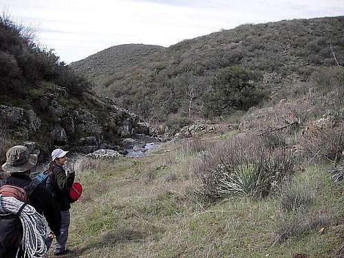
Head down the trail a couple minutes and you’ll see an obvious use trail to the northwest heading down canyon, parallel to the beginnings of the creek. That will take you to the first drop.
Red Tape
A Forest Adventure Pass is required and parking is not allowed at the Lazy W Ranch and is very limited near the camp's entrance.
Section Break Down
Upper Canyon – Approximately a mile plus approach on a poor use trail.Upper Tech Section – Three significant drops close together
Mid-Canyon Slog – Something less then a mile, with a few fun features, but mostly bushwhacking.
Lower Tech Section – Four repels, including the best drop I’ve done.
Lower Canyon Slog – About three and a half miles of nasty bushwhacking.
Exit Trail – A mile plus of "heavenly easy" hiking back to your car.
Route Discription
Leave the Blue Jay or Falcon Campground using the Falcon Trailhead. After only a couple minutes you'll find the Upper Hot Springs Canyon use trail to the northwest and start heading down canyon.The approach trail could stand to be trimmed back a bit, but you shouldn't have much trouble following it. You’ll be getting your feet wet real quick so be prepared. The approach trail bypasses the first fall, Calius's Cascade, and continues down canyon. As you approach the second fall the use trail appears to end. You’ll have a choice here: Gear-up and rap into a deep pool or bypass it on an exposed use trail high on canyon right.
Just after the second waterfall you'll enter narrow passage I named Frank’s Single Track Rut. The Rut leads you to a short waterfall called Single Track Falls. Building an anchor here will be a challenge. We used a meat anchor and I down-climbed to canyon right. The down-climbing wasn't as bad as it looked, even at the peak water flows we encountered.
In a short distance you'll find the next obstacle, a very sweet, two stage waterfall called Life Raft Falls. The first stage was a 15’ low angle cascade that poured off to the right, then fell vertical for another 12’ and finished by again cascading left for another 30’. There was a good anchor in place off a tree; also there was an old, braided nylon, fixed hand line there.
During low water flow, skilled canyoneers, utilizing the fixed hand-line at Life Raft falls, may be able to complete the upper and mid sections of this canyon without deploying a rope.
After the three significant falls in the upper technical section you enter the semi-technical mid-canyon section. While this section had several nice down-climbable water features, it was mostly tough travel through a debris clogged, slippery, watercourse. No trail at all, and travel outside of the watercourse was mostly impractical. In this section we down-climbed and /or jumped the 20’ Mid-Canyon Falls.
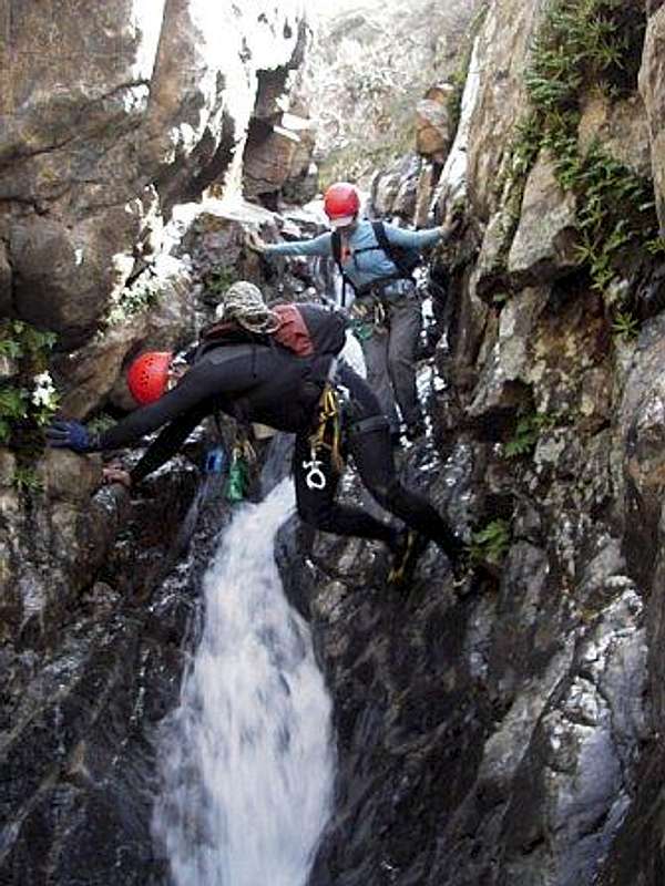
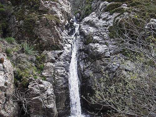
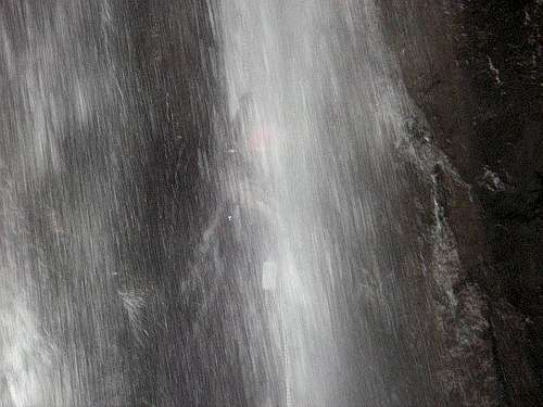
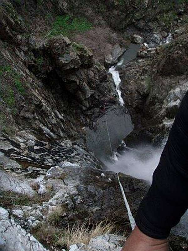
At the end of the mid-canyon slog the canyon opens-up and you’ll notice a large drop ahead. You’ve reached the top of Tanrverdi Falls, the 160’ jewel of the canyon and the beginning of the second technical section. This fall is near vertical with one short free section. The water flow was great when we were there. The rap is anchored on a big rock out-cropping just to the left of the falls and requires a short, exposed, and uncomfortable, swing-out onto the face to weight the rope. The repel goes free for a short distance near the top. As you continue to lower you inch closer and closer to the water flow. About two thirds of the way down you move into the water and become completely immersed in the flow by the bottom. I have to say it’s the most exciting rap I’ve ever done! Anywhere!
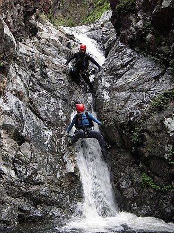
The big rap was quickly followed by 3 other 20’ to 40’ raps: Lower Tanrverdi Falls, a short unnamed fall, and Last Falls.
The Lower Tanrverdi Falls anchor, consisting of a rock chock and a knot chock found very high, canyon left/center, was a little dubious. I inspected it, the rock chock was loose, so I reset it. The knot chalk seemed solid in the direction of pull and the two were well equalized. I considered replacing the anchor with a couple pins, but time was starting to run short and we were a little cold so we used the existing anchor.
The next fall had a sun faded, manky, single strand of webbing for an anchor. We quickly replaced it with a new redundant anchor.
The Last falls rap basically had the same simple anchor as the last rap. This time we just used it.
Bad news; you’ve had only covered 1/3 of the canyon. Good news; all the technical canyoneering of the canyon behind you. Travel in the lower canyon is still very tough. No trail at all and it’s seldom that you can put together a few easy steps. Most progress is still in the watercourse where your foot either slides on slippery rock, slips on uneven footing, or gets hung-up on some unseen obstacle. When you do get an opportunity to move to dry land you’ll be bolder hoping or bushwhacking.
Towards the end of the day, when you’re about a half mile away reaching the Lazy W Ranch, look for an exit trail canyon right. Then continue down the road to the San Juan Trail parking area to recover your car.
Anchors and Bolting
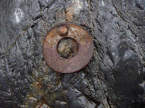
I'd prefer to see the route left wild and natural. Because of the difficultly, length, and with a 4b rating this canyon will never become a trade route for newbie’s and noobs. The current anchoring challenges enhance the route for the seasoned canyoneer and bolts will just dumb down the route to a class 3 canyon.
We added a third strand of webbing on the T falls anchor, shortened it a bit, and added a second quick link to expedite the rope recovery. It wasn't that scary swinging out to weigh the rope, and even with the increased lateral forces from the shortened anchor it's still plenty strong.
The anchor on lower Tanrverdi Falls could/should be improved. But the entire area was wet and I was very cold when I was down there. I think in time a better anchor will be devised. And the anchor on Last Falls needs to be replaced and upgraded to a redundant anchor.
Oh!
Did I say this is in suburban Orange County!!LInks
Link to trip reporthttp://groups.google.com/group/socal-canyoners/browse_thread/thread/aa64486662674a9b