
|
|
Canyon |
|---|---|
|
|
33.55563°N / 117.39844°W |
|
|
Hiking |
|
|
Spring, Summer, Fall, Winter |
|
|
San Mateo Canyon
The San Mateo River flows through a beautiful canyon in Southern California's Santa Ana Mountains. The canyon and its tributaries are part of a 38,484 acre wilderness area by the same name managed by the US Forest Service, Cleveland National Forest. A few trails at the northern and eastern ends receive medium-heavy use, but interior trails are seldom hiked and are begging for exploration by those that like challenging terrain and solitude.Best visited in fall, winter, and spring because this is a low-mid elevation area that can get very hot in the summer. Winter time lows can drop below freezing but are usually a little higher due to the proximity to the Pacific Ocean, which has a moderating effect on temperatures. Southern Californians are blessed to have wilderness areas like these to go backpacking in when the higher elevation mountains are snow-covered!
The San Mateo Canyon is rimmed by low mountains covered with chaparral and coastal sage. Many deep drainages join the main canyon and hide a lush growth of vegetation, with sycamore and oak woodlands thick along their bottoms. Annual rainfall averages 15 to 20 inches, most of it falling in winter and early spring. Spring brings a diversity of wildflower blooms. Summers tend to be very hot and dry, though you will probably find small pools in San Mateo Canyon most of the year.
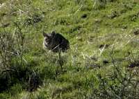 Bobcat near Oak Flat
Keep an eye open for wildlife including: 139 bird species, 37 mammal species, 46 reptile and amphibian species, seven species of fish. Lizards, rattlesnakes, coyotes, skunks, and mice are commonly seen; bobcats and mountain lions are rarely seen. The Oak Flat area is part of a grazing lease and you may see some impressively large long-horn cattle.
The east-west San Mateo Canyon Trail follows the main canyon for 7.5 miles near the center of the Wilderness, and provides access to what is probably the best camping in the area: fields of grass, shady stands of oak and sycamore, the best chances for water. This trail is joined by at least six others, most of them easy to moderate, including the 5.4-mile Tenaja Falls Trail. Tenaja Falls, when spring brings a rush of water, is a dramatic sight. Poison oak grows richly around the falls even when the creek dries up.
Getting There
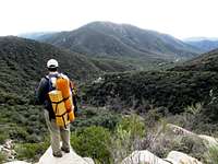 View near Tenaja Falls
Highway 74 runs along the northern boundary of the wilderness and gives access to the popular Bear Canyon Trail which starts near the Ortega Oaks Campground/RV Park.
To get to the Tenaja Falls Trailhead (high-clearance and 4wd vehicles recommended) take I-15 to Clinton Keith Road, go southwest, then right (west) on Tenaja Road - a total of 9.9 miles. Turn right onto Rancho California Road (FS 7S01 Wildomar), continuing 5 miles to the trailhead. The Tenaja Falls Trail connects with the San Mateo Canyon Trail. There are no bridges, so in winter and spring be prepared to ford the river and any side creeks that the trails cross.
Link to a map and short description of San Mateo Canyon Wilderness Trails
Buy a waterproof/foldout map of the San Mateo Wilderness (also includes the Agua Tibia Wilderness)
Red Tape
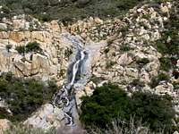 Tenaja Falls
No campfires are allowed in this wilderness area due to the high risk of wildfires.
Dogs allowed on leash only.
Wilderness permits (free) are required for overnight stays. Contact the Trabuco Ranger District (they can fax you a permit or you can pick it up in person).
Please practice Leave no Trace Ethics.
Contact the CA Department of Fish and Game for fishing and hunting regulations.
Camping
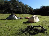 Camping in Oak Flat
There are good camping spots along the San Mateo River (be sure to find a spot at least 200 feet from water and trails) and in the Oak Flat area. Water may only be available in the late winter and early spring.
External Links
 Tenaja Trail
Cleveland National Forest
Backcountry Safety
NWS Weather Forecast (click on the word "Beach" in Newport Beach - approximate location of San Mateo Canyon)
My 22 Mile Loop Trip Report, New Year's Weekend 2010-2011
Bluewater Traverse Trip Report