Indian Peak (UT)
Where?
"Where is this peak located?" asked my wife as I drove north from Zane on a dirt road that seemed to head nowhere. We had driven up in the late morning from St. George where we had spent the night and I wanted to visit Indian Peak, the 23rd most prominent peak in Utah. One of my quests is to visit every one that I can that is on
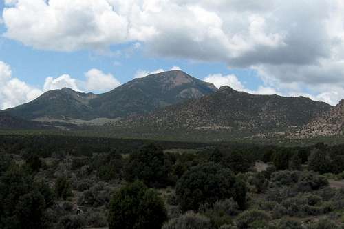
the 100 highest prominence list and I had whittled the number down by one the day before on West Mtn Peak that is near St. George. At 9790 of elevation, Indian Peak looked like a worthy one to get on the way home, BUT to get to it, we would have to drive a lot of dirt road miles and after leaving the pavement at Beryl, we were destined to see some of Utah that few ever visit.
The road we were on hooked into the Pine Valley road and from there it pretty much headed straight north as it made its way between the Wah Wah mountains and the Indian peak range. Using the map I pointed out to my wife where the peak was and she became the navigator and started watching for roads that the BLM had put names on. Some spur roads had names, others
didn't. As we went past one that headed for the Hamblin Valley, I thought of those two people who were stuck in the snow for many days the past winter. This country was no place to get stranded in during that time of the year. After about 20 miles, we saw our first vehicle in the past 60 miles, an ATV actually, with a young lady holding a small child on her lap.
Shortly after waving and passing her, we met three more vehicles and that was to do it until we got onto the road that led to Indian Peak itself.
Indian Peaks Wildlife Management area
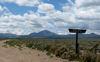
![You are entering...]() Area signage
Area signage
The road led into the Indian Peaks Wildlife Management area and we stopped at what turned out to be the HQ for this unit. Of course, no one was there although several campers and ATV'ers from Cedar City had taken up residence for the weekend. A picnic table there next to the HQ building gave us a chance to eat some lunch (a late one) and from there we headed up the road that goes north of the peak and then cuts back along the side of it. It was 4.8 miles along a often rough but not overly diffiucult road and following it we found a spot at the 8000 foot mark that looked promising. In checking my map and GPS, I figured it was only a mile to the summit and about 1800 feet of elevation gain. So, I grabbed my daypack and left my wife to tend to her iPod and some reading she wanted to get done and started up the slope, following the elk and deer paths that were everywhere. Some of the paths were better than others and I just kept zigzagging up them until I crossed over a barbed wire fence and then plunged into a steep draw that had some trees in it along with some residual snow. I worked my way to the left of a cliff face and soon found myself on the north ridge with 800 feet of gain behind me and a thousand to go.
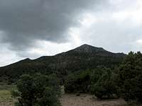
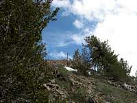
![Storm clouds gather]() Storm time?
Storm time?
I couldn't go directly up the north ridge, it was a cliff face so I traversed around to the right (west side) and worked my way through some brush, some trees and then a couple of talus slopes. The talus was just loose enough to require attention to my footwork and I worked my way across them to more solid ground and then went directly up for the ridgeline again. It was here I hit more snow and had to traverse a bit more to the west side but all in all, it was all class 2 with no difficulties really.
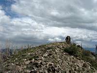
Finally, I saw the top of the ridge near the summit and was I surprised to see a barbed wire fence strung right along the ridgeline which extended right up to the summit where a large cairn stood. My picture of it will provide a better description than I can at this point.
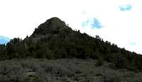
![I went to the right (west)]() After hitting ridgeline, I went to the right of this
After hitting ridgeline, I went to the right of thisThe summit
![The summit]() Summit cairn
Summit cairn
I made my way up through some snow and some talus and found a spot where I could go over the barb wire fence without much of a problem. Interestingly enough, I noticed this weird looking cairn up the ridge a bit and knew that it was the high spot of this mountain. Sure enough, a sign on the cairn proclaimed what I thought was true, it was the summit. A mailbox adorned the top of the cairn and when I opened it, I found an unprotected notebook along with two ziplock bags full of paper scraps (where people had signed in). Of course I could find no pen nor had I brought one myself so instead of signing the register, I took pics of a few of the pages.
Nearby was the benchmark and so I photographed it along with my GPS. I talked to my wife via the 2 way radio and snapped a few pics but the darkening clouds caused me to beat a retreat off of the summit and head back for my vehicle where I had a wife waiting. The return was uneventful although I
was very careful as I made my way back through the talus field.
![The summit cairn]() Summit cairn & mailbox
Summit cairn & mailboxAfterthoughts
Total mileage up and back was two miles. The elevation gain was 1800 feet and so considering the distance was just one mile, there were plenty of steep sections to contend with. Time up was an hour an a half and time down was one hour. All was cross country and some time was consumed route finding. There are other route possibilities up this peak and while mine was the shortest in distance, it may not have been the fastest. A good route looked feasible from the southeast side.
I did see one deer on my way down and that was it for wildlife encounters.
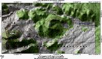
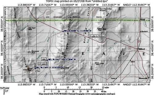
GPS waypoints: lat/long nad 27
I parked here at 8000 feet
38.27696 113.86923
Near the ridgeline at 8760
38.27325 113.8760
On the west side
38.26998 113.8760 9300
Distance from HQ to parking spot 4.8 miles
Distance from HQ to Pine Valley road 6 miles
Distance from Pine Valley Road to Highway 21 15.2 miles
Distance from Highway 21 jct and Milford 34 miles
or roughly 60 miles from Milford to where I parked for this hike.
![Summit mailbox]() The summit mailbox
The summit mailboxI want to visit this area again
This area grows on you, in fact the western Utah desert mountains all cast a spell that will lure you back. The wild horses, the proghorn antelope, the
feel of the area and the clear skies, all are magnets. At night the stars are
incredible and the lack of light pollution will have you bringing a good telescope to peer at the heavens with on additional trips once you realize
what an amazing gem this area is.
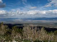
![Looking NE]() NE view
NE viewWarning !!!
This is an isolated area. Be sure to have plenty of gas, water and food in case of a breakdown. During the weekdays, there is not much traffic and should you have a problem, it might be a day or two before someone comes along. Cell coverage does not exist out there and so be aware of these facts. Travel time from Salt Lake city is about five hours. Head for Beaver Utah and then take highway 21 to Milford. A camping area is available at the Minersville Lake state park.
![Hike is easy, getting there is tough]() The getting there
The getting there


Comments
Post a Comment