It was January 18, 2007 and we had just come off three tough days on El Pico de Orizaba. We headed west toward Amecameca for our second of two climbs that we had planned for that week. Orizaba had taken a toll, broken equipment, blisters, bruises and quite a bit of sleep deprivation. I haven't done the TR yet, but if you want to see the Orizaba video, it is at: Orizaba II
I first realized the true amount of mountain we had to climb when I was reading the route description of Iztaccihuatl that Rob had found on the web. During our trip prep, he had done some googling and found additional accounts of the Arista del Sol route that we intended to climb. Without looking, I believe the Secor book states that the summit of Iztaccihuatl can "easily" be reached in one day from La Joya. Key word being "easily." The report Rob had pulled easily put the climb in the 12 + hour range which opened up a whole bunch of other logistical questions. We were sure to make Amecameca in daylight, and easily get our climbing permits before the office closed, so this begged the question: Do we go straight up to the mountain? Camp at La Joya? Move to the Grupo de los Cien hut?
Hold that thought. The westbound bus we had hoped on from Puebla was slowing and the driver was yelling something at our group. Rob and Dave handled the dialog exchange and we promptly exited the bus on the side of a Mexican tollway. The look of disbelief on most of the faces in our group was priceless. Unfortunately my video gear was well packed and I missed this the opportunity to immortalize this moment. Our instructions were to get off of the exit median we were standing in and cross the overpass where we were to pick up the next and last bus to Amecameca. Instead we grabbed a couple of nearby taxis sitting in a parking lot just off the highway and for a nominal fee of $15 per, they took us the remaining 35 minutes to downtown Amecameca.
[]
Amecameca , Guadalupe and The Librarian
While I continued to pour over route details, some of the others bounded off to deal with the climbing permit situation. It was at that point we were approached by Guadalupe, a local taxi driver who I would recommend to every foreign climber that visits the area. We were still debating whether or not we should go up the mountain right away, or plan to get to the gate at 7am when it opens. It was a short debate, and after 3 nights on the side of Orizaba, hotel beds sounded like the right call. We were banking on a 7-11 hour roundtrip climb the following day. The group checked into the Hotel San Carlo, right next to the permit office and stashed our gear. The San Carlo room rates were between $12-$15(US) per person per night. We also made arrangements for Guadalupe to pick us up a 6am in his van. We were to pay $20/each for the round trip upon our return. Two key points: permits give you access from 7am till 9pm for the day of your climb. The fee was also more than expected and we were charged 20 pesos/person/day instead of the 10 pesos we had been expecting to pay.
A quick note on the San Carlo. There is a closet under the stairs that locks, and the desk clerk can see it at all times. If you ask him, he will let you store gear under there and keep the key in his pocket. Alternatively, you can leave gear in your room which is several floors up.
A short hike around town and we selected a restaurant to the southwest of the town square. Normally details of restaurants are not an interesting piece of a climbing trip, but this one is worth mentioning. We sat down to an excellent meal, of which I actually ordered a second(the whole meal), along with a couple of cervezas. When the check came, we had some discussion as to how to cover it, and that was when Dave pulled out his USD 50 bill. That was way more than the tab, and too much for the restaurant to break, so we figured out another payment. It is also important to note that during the meal we had all noticed what must have been the business manager, who was a twenty something woman sharply dressed in business attire and bearing a laptop. At least one of the single guys in the group found her intriguing and she was named "The Librarian". This is when something remarkable happened. We left after paying, and cruised around town for about an hour buying some water and other things. As we were just about to walk into the San Carlo, our waitress from the restaurant and The Librarian came running up to us. After translating, it turned out that Dave had inadvertently left the fifty dollar bill on the table and they wanted to return it! Dave and Dr. Sheets went back to the restaurant with the women to get the money. Certainly in the US, this would have been treated as finders keeper, or a big money tip, and I think we were all pretty floored by the honesty and effort they went to in returning that money.
The next morning, Guadalupe was at our hotel promptly at 6:00 am to take us to the gate. We had slimed our packs down as much as possible; Dave even opted for trail running shoes. Rob and I stood firm to carrying crampons as a "you never know" type scenario could come up. I had dropped a few pounds of video gear, and probably had it down to 15lbs total. No tripod and only one 7 hour battery. It seemed like a fairly long 25 km ride in the taxi from Amecameca to Paseo de Cortes, but quite scenic. There was not a whole lot of conversation, but rather focus on the large task at hand. We were going into this knowing quite well we had drastically underestimated Iztaccihuatl. We reached the ranger station at around 7:00am, and had to bang on the door for a bit to be let in. The check in process took a while. We were issued 10 wristbands which made me think we had infact double paid. Whatever the case, shortly thereafter we were back on the road. Leaving the closed gate to Popo behind us, we headed toward the microwave towers and onto La Joya. Key lesson number two: Just because the gate at La Joya opens at 7:00am does not mean you can be on trail even close to that time if coming from Amecameca.
The Climb - January 19 Summit bid
For some reason I had been expecting to see huts like the Grupo de los Cien hut at La Joya. However, the structures there should hardly be considered huts. No closing doors and tarps for walls. I guess they would hold off the rain or snow if needed, but I would hate to sleep in one. The transition from the taxi to the trail was short and I noted 8:10am on my watch as we took off. Dave and Sheets blasted ahead at a pace that we have reached the top in only a few hours; one problem, we went the wrong way. There are two trails leaving La Joya, one that heads due north, to climber's left and one that heads straight at the cliff in front of you, climber's right. Take climber's right. Circling back, we were on the correct trail by 8:35am and doing distance.
I was feeling the camera weight as we pushed up the trail. 14,000 feet came and went very quickly and we were moving faster than a 3 hour pace for the first leg that would take us to Grupo de los Cien hut. Stopping only briefly to water up and shoot some video, the sun rose quickly over Orizaba and Sierra Negra. The wind also picked up a ton of energy. It became quite difficult to shoot video with the lens hood catching the wind and buffeting wildly. About 2 hours and 45 minutes in, we spotted the hut, and began to descend towards it. While we were encouraged that we had reached the hut at just about noon, I think that the grim reality began to set in that even at a quick pace, the summit would not be reached until after 2pm making a 6pm return time very tight if not impossible.
Little time was wasted at the hut, and the entire group pushed higher. Beyond the hut, the route quickly becomes Class 3-4 scrambling(depending on the line you choose) and Class 5 should you stray significantly from the route. The trail pitched up quickly from the hut with loose dirt on climbers left, and rocks to climbers right. Rob and I joked about "Maybe there's a ridge route" but I later realized that he was not actually joking. I was leading at this point and took a line pretty much where the scree met the rocks. This went for probably about 200 vertical feet before I bore climbers right to hit the ridge proper. On the ascent we found another set of hut ruins. At some point, a huge iron cross becomes visible, and we aimed our route in that general direction. We continued the ascent up through Class 3-4 rocks of which I had to backtrack at only one point. If you climb too far to the west, climber's left of the ridge itself, that is where you may encounter Class 5 and some cliff outs. Somewhere high above we crossed the 5000 meter mark, and congratulated John as a new member to the 5000 meter club. The video below shows the inside of the hut, and the view of it from the climb out of the valley.
Passing the hut ruins at 16,750, we stashed some water under the foundation for the descent. Viewing the remaining route was again a solemn moment and for some the moment that they realized the breast of Iztaccihuatl would wait for another trip. Dave and John reached their high points somewhere near this hut and decided they would head down and hold the taxi. Rob, Sheets and myself would push on and go for the summit. It was now about 1pm and we were right at the point of return to catch a 6 pm taxi. We exchanged radios, tested them and then parted.
From the hut ruins, we crossed the ridge and ascended a scree slope towards where the belly glacier had to be crossed. The wind had died a bit and this enabled better communication. Reaching the next ridge, the belly glacier lay before us with the easiest access being a steep slope covered in water ice with rocks poking through. It was now just after 1pm. In the distance we could see what appeared to be the high point and it looked a long ways away. We searched for an easy access to the glacier, but nothing looked too easy. Again we rehashed the odds of getting back for the taxi. Would Dave and John be able to hold it? This was a tough call. The weather was perfect, and the forecast suggested it would stay that way. Rob and I had warm clothes in our packs, and some extra bars and food. We also had a water cache. After a few minutes of discussion we realized that worst case scenario was missing the taxi. This meant one of two things would happen: 1) We would bivy at either the Grupo de los Cien hut, or La Joya; or 2) We would hike out the extra 25km to Amecameca. Considering neither of these options seemed too unpleasant we opted to go for the summit. Sheets however had enough for one day. He was very fast on trail and a solid rock climber so the idea of descending solo did not cause him concern. He decided he would bolt and catch Dave and John on the trail below(which I believe he did).
Down to the two of us, Rob and I lashed on crampons and charged across the belly glacier. It was melting pretty quickly and we encountered only very small crevasses. The total crossing took maybe 25 minutes, probably less. On the other side, we climbed La Arista del Sol towards what would be the first of four high points we would tag. I arrived slightly ahead of Rob, and got out the video gear to shoot a bit. Upon his arrival, the GPS gave us a reading of 5230m...but this couldn't be it. Further north and across the breast glacier there was a dirt ridge with a couple of high points on it. There was a cross protruding from one of them. I crossed alone with the GPS to get an altitude and to let Rob know if it was worth crossing the glacier. The only major crevasse is in the center of this dying glacier, and easily circumnavigated.
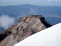
After crossing the glacier I ascended to the top of the dirt and headed for the cross. The view of the head was perfect and unobstructed from there. At the cross, I once again measured 5230 meters. Motioning Rob to come over, he tagged this point, then we headed to the next high point was slightly to the west of our present position. At first this read 5232 meters, but then leveled at 5230. One last high point was to the south and west of where we were. We tagged this one, and it was the only one that read 5229 meters. Along this tour de summit(3 high points), we took several pictures to be sure we had ourselves on the highest point. Post trip research actually indicates that the breast glacier used to be some 10 meter thicker, and the summit elevation higher.
Returning to the first of the high points we encountered, I took the opportunity to roll some tape. We loitered a bit on the summit where is was a balmy 42 degrees F. It now had to be getting close to 3pm, and time to go. The descent of the ridge back to the belly glacier was completely uneventful. Once back across the glacier, we took some time to re-pack the crampons and give Dave a ring on the radio. Updating our ETA, it sounded as though they were down and Sheets and John had hopped a ride back to Amecameca. Dave would try and hold Guadalupe, or send another cab up later if he could not. The video below is from the point at which you gain the summit plateau. You can see the point with the cross, a second high point to the west, and then finally the 3rd high point.
Getting back down
The route back to the hut ruins also went quickly and I pulled the stashed water from behind the foundation. It was cold and refreshing as I had begun to dehydrate a bit. The next section of the route was a little more interesting. This was the class 3/4 climb out of the Grupo de los Cien hut area that we followed on the way up. During our ascent we stuck close to the ridge, but on our descent we wandered to climber's left(west) of the ridge. As a result, we cliffed out a couple of times. Each cliff was given away by the rappel anchors that preceded it. The backtracking was tough, but once back on our ascent route, things went better. With the remaining daylight, we made our way down to the hut, and more importantly good hiking trail.
At the hut, we watered up and headed off. The ascent back up from the hut was painful, but the route quickly turned back downhill. We met a group of climbers coming up, bound for the hut. They inquired as to some route information and moved on. Just after that, we strapped on the head lamps. While the trail is very straight forward in the daylight, the false paths of other climbers can be deceiving in the dark. The route weaves from the west side of the ridge to the east side of the ridge in a couple of place and can add to the confusion.
About midway down the last section, I turned where I thought the trail was descending. This turned out to be a false path. Off to my left I saw Mexico City, and the outline of Nevado de Toluca. It suddenly occurred to me that this was not good and that we were descending to the north. I had fallen for one of the false footpaths. Without hesitation, we broke out the GPS and put the pointer to our ascent route. We were not far off route and turned straight around. The right thing to do here would have been to re-climb the short section we had descended. Instead, we took a straight line at our ascent route. This lead to the most miserable scree slog imaginable. Shin deep loose apple sized talus that sucked the energy from every step. As we ascended back to our line, it robbed us of at least one foot for every two we climbed and filled our boots with gravel. For such a short distance it took everything we had. Back on trail, we radioed Dave; he had held the cab and was waiting. We owed this guy big time.
The trail continued to drop, and the dust was nearly unbearable. We had a tail wind that was taking the dust from every footstep and making sure you got a lung full. The natural convective cooling from walking was also totally negated by the tail wind. Every step down was burning the hot spots on my feet, and getting them ever so closer to becoming blisters. The last 3 km seemed endless, which is amazing considering it was all downhill on soft trail.
After what seemed like and endless journey through the dark with me lying to Rob about how close the GPS said we were to La Joya, we finally saw the lights. We flashed our headlamps to let them know it was us. Finally at 8:25pm we rolled into La Joya where we found Dave waiting with Guadalupe a full two-and-a-half hours later than we said we would be. On the drive back to town, we talked mostly work; maybe it took our minds off the hunger. Back in town, we took Guadalupe and Dave out for cervezas and dinner at a restaurant of their choosing. We went to a great local place with excellent home cooked food. It is hard to really express how thankful we were that Dave & Guadalupe waited for us. We would have been ok, but that last 25km would have been awful.
Epilogue
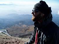
On this trip, Rob and I teamed up with Dave, Dr. Sheets and John. It was a pleasure climbing together and I hope we can do it again.
Thanks again for holding the cab, Dave!!
I would also be remiss if I did not give photo credits to Mr. Rob. He ran the stills on this trip and I rolled the HD video. That said, some of those were pulled from video frames for this report.
Good TR, yo. Izta reminded me a lot of Wetterhorn in Colorado. That is, if you kept on stacking one Wetterhorn on top of another. Fun climbing but makes for a long ass day.
Ya, I cliffed out a couple of times coming down. Good thing those rap slings were around.
It would have been nice if they stayed open late - I could've really used a taco at the end of that climb.
As for permits, I spoke with the park service just before we went down and it was 10 pesos. We were told the prices went up *that day*, which left us a bit suspicious. After haggling for a bit, I realized that we were debating over $1 USD and that we had too much other stuff to take care of prior to leaving. As Dan said, we were charged twice what we expected and received twice the entrance wrist bands, so I think it was just confusion. Either that, or maybe my spanish skills are worse than I thought and I argued them *up* in price...
Parents refers to a larger category under which an object falls. For example, theAconcagua mountain page has the 'Aconcagua Group' and the 'Seven Summits' asparents and is a parent itself to many routes, photos, and Trip Reports.


Comments
Post a Comment