Statistics
| Leg | Distance (miles) | Elevation Gain |
| Beartown TH to camp | 9.5 | 2600' |
| Camp to Jagged Mountain | 2.9* | 2600' |
| Jagged Mountain back to camp | 2.9* | 0 |
| Camp to Beartown TH | 9.5 | 2900' |
| Total round trip | 24.8* | 8100' |
* The GPS unit was not happy on Jagged Mountain and added quite a few zigs and zags, so these numbers may be a few tenths of a mile high.
The Drive to Beartown
We left Silverton one sunny morning and quickly learned that getting to Beartown was not going to be simple. First of all, there are 2 highway 110’s at the east end of town. The wrong one heads north. The correct one, also known as County Road 2 or Blair St or Animas Forks Road, requires a right turn off the main drag (Greene St.) and heads ENE.
About 5 miles out of town we turned right on to CO 4 as directed. After about half a mile the road splits. It turned out it didn’t matter which way we went, as the roads merged back together again about 1.1 miles after the split. The upper road passes the Old Hundred Gold Mine which offers tours.
Soon after the roads converge, there is another split where you must go left and start the uphill climb to Stony Pass. At the time we were there, the road to Stony Pass (County Road 3) was not labeled at all. We found our way up over the pass and down the other side to FS 506. FS 506 starts with a ford of the Rio Grande River, and the road immediately becomes much more rutted than the Stony Pass road. On FS 506 it is 6 miles to the Beartown Trailhead. We had a high clearance vehicle with a long wheelbase and bottomed out only once in the last half mile. At this point we saw several 4WDs parked alongside the road, which would add another half mile and a little elevation gain to the hike.
There is room for about 2 vehicles at the trailhead and we got one of them. We divvied up the gear and hoisted the packs.
The Base Camp Trek
Just as there are false summits on peaks, it appeared that Hunchback Pass just kept getting higher and higher. But we were fresh, and before long we had reached the high point (12, 493’) and were headed down into the Vallecito Creek drainage. Of course the downhill portion carried with it the knowledge that the uphill punishment was yet to come.
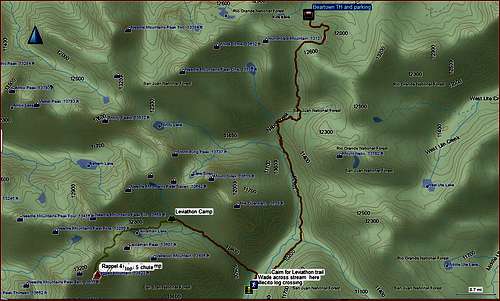
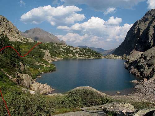
![Beartown to Jagged route overview]() Beartown to Jagged Route Overview
Beartown to Jagged Route OverviewWe passed the turnoff to Nebo Creek trail on the left, then passed the Rock Creek trail, also on the left. I had marked a track to Leviathon Creek on the GPS prior to the trip, so when we saw a trail heading to the right into the woods near my GPS track, we took it. On the way back we found a cairn that followed the edge of the woods. In this area there were many social trails.
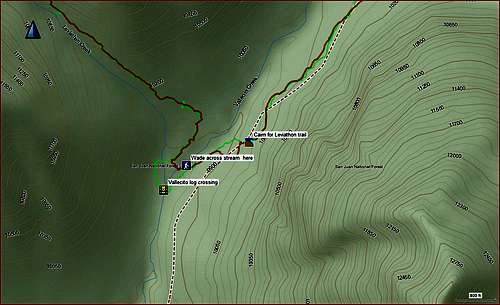
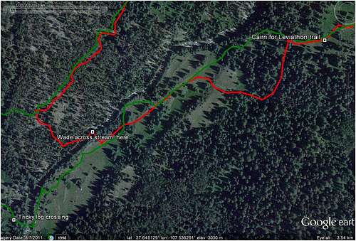
We took quite a bit of time trying to find a river crossing. Finally we decided on a series of rock hops, followed by a skinny log crossing to a couple of additional rock hops near an obvious stock crossing. The skinny log wasn’t enough for me, resulting in 2 boots full of water. I wrung out the socks and liners, saving the dry socks for the next morning. On the return, we scouted Vallecito Creek from the west bank and found a much better spot for crossing. It required only 2 steps on bedrock through a shallow area in the creek.
![Vallecito stream crossing]() GPS track of Vallecito stream crossing
GPS track of Vallecito stream crossing
There is an attached GPX file that can be used for more detail on the stream crossing.
![Stream crossing in google earth]() Vallecito stream crossing per Google Earth
Vallecito stream crossing per Google Earth
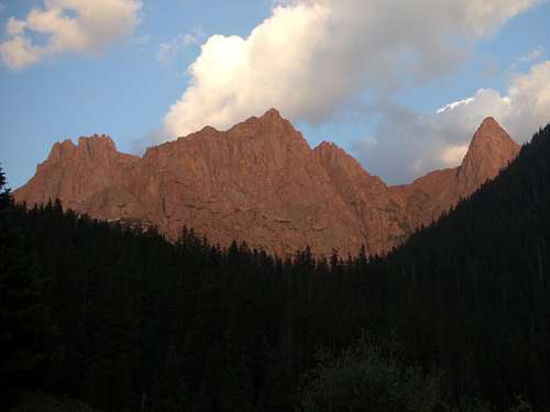
On the west side of Vallecito Creek was a flat area containing a large tent, possibly used for hunters. We picked up a highly visible trail and followed it easily up the drainage. A little more than 2 miles after crossing Vallecito Creek, we crossed a small stream and found a lovely flat area for our base camp at around 11,500’. We were treated by the setting sun to a reddish glow on the surrounding peaks.
![Evening light in Leviathon Basin]() Evening light in Leviathon Basin
Evening light in Leviathon BasinThe Climb
Summit day dawned clear and remained that way throughout the entire day. As we left camp, the trail became faint in places, but with maps we were able to point ourselves in the right direction and eventually pick up the trail again.
![Leviathon Lake]() Looking down on Leviathon Lake (from the west)
Looking down on Leviathon Lake (from the west)
We skirted Leviathon Lake on the north, then climbed through a rock field to a saddle just west of Leviathon Peak. From here there was a great view of the climb. We took out the map and directions from Roach’s Thirteeners book and studied the route.
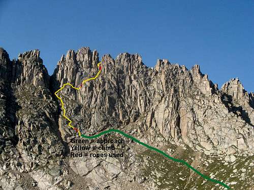
In the photo below, the green line is the approach, the yellow is the route, and red marks areas where ropes were used.
![Jagged route color coded]() Color-coded climbing route for Jagged
Color-coded climbing route for Jagged
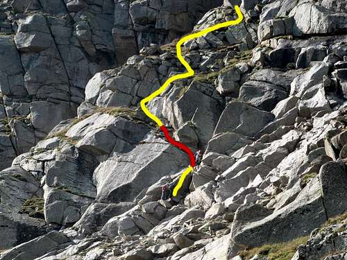
We contoured around to the southwest toward the saddle to Noname drainage, then followed trails to the base of the climb. A few hungry-looking mountain goats were hanging out so we planted our trekking poles firmly and located the start of the climb. The photo below is a close-up of the first crux of the climb.
![Jagged climb start]() Jagged climb start - red is rope assisted climb
Jagged climb start - red is rope assisted climbWe worked our way up the mountain, frequently referencing Roach’s Thirteeners book, and summited under a beautiful clear blue sky. To descend, we reinforced the webbing and added a rappel ring, used 2 160’ ropes and enjoyed the ride. The first rappel was the longest and most fun. We had kept an eye on the way up for rappel stations, but finding them on the way down still required some hunting. We retrieved our trekking poles at the base of the mountain, headed back to our base camp and watched the sky begin to cloud up ominously.
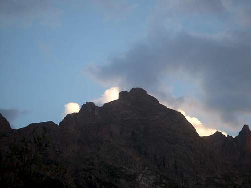
![Encroaching weather]() Encroaching weather in Leviathon basin
Encroaching weather in Leviathon basin
The Departure
We awoke to a gray sky. After a quick breakfast, we scrambled to pack up the gear before it got wet but didn’t quite make it. It rained the entire way out but we didn’t care, and the rain kept us cool for the long slog back up over Hunchback Pass.


Comments
Post a Comment