History and Prep
My friend Andrew and I had been trying to get together a trip to Jagged for five years. He lives in Durango, so it is one of his 'local' peaks, and myself, now living in Albuquerque, it is easier to get to than when I lived in Boulder. In years past, several attempts were thwarted by unexpected plans, jobs, and anniversaries. But this year, we made a point of it, and put it in the calendar,
and actually bought the Durango & Silverton train tickets. Now we were committed (although all this occurred only two weeks before).
Fancying ourselves hardmen (but not actually being hardmen) we set our dates for June 23-25. We were banking on a somewhat low snow year for our success (and the stable June weather), but Andrew, being a bold climber on mixed terrain, would prove invaluable. We also made the somewhat dubious decision of not bringing any snow and ice gear, but we figured with a good rack and a rope, and the reportedly good rock, our wits and our climbing footwear would get us up the mountain.
Day 1 - Approach
![Rafters]() Rafters inflating
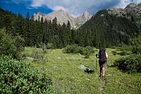
Rafters inflatingThe Durango & Silverton train seems to be less climber-friendly these days. The early train only stops at Elk Park, so we had to take the 9am train which only stops at Needleton, and not start hiking until 11:30. But the weather forcast was good, the days are long that time of year, so we still had a long time before the sun would set before which we needed to find a suitable high camp. Our goal was the meadow at 11,800 feet, which Roach describes as being 7.9 miles in.
![Watertank Hill]() train at Watertank Hill
train at Watertank HillAfter an uneventful train ride, we started off at about 11:45am. Andrew had been up Pigeon before, so he knew a little bit about the trails north of Needleton, but had never been up Noname. We were depending on Roach's route description to get us to the Noname trail, 2.5 miles upriver. The first (and the only one, really) obstacle is known as Watertank Hill. This is where the banks of the Animas River cliff out, and the trail forces you up and over, about 200 feet of steep hiking. Many books describe this as being a very unpleasant part of the trip, Roach describes it as being Class 2+ going down the upriver side, and says that some even use a rope here. After we finished this section, it seemed like all a bunch of hype, as it was not bad at all (no rope).
After Watertank Hill, we meandered through the forest along the banks of the Animas following the sometimes-faint trail. At 1:15pm, we found ourselves at Noname Creek, where there is a nice log to cross with, with another log set up as a handrail. The trail continues here closer to the river, which we missed at first, being too far away from the river. Eventually we found the old telephone poles that mark the start of the Noname trail. There are in fact
two poles. The first is fallen down and does not mark the start of the trail, and second is still standing in an open clearing, and does, in fact, mark the start.
The first quarter-mile the trail is a little faint, but after that it is quite good. It even seems that somebody has taken the time to maintain it, with fallen trees having been sawed and cleared. The trail climbs at a steady grade all the way to the giant, flat meadow at 10,820 feet in the drainage. The only part that caused us any problems was a marshy-meadowy area about three miles up where the trail dissappeared for a while.
![Meadow]() The meadow at 10,820 ft
The meadow at 10,820 ft
Roach's descriptions of finding the trails where they branch off to the left to get towards Jagged are spot on. First there is a cairn at the end of the giant meadow that takes you left and to another meadow at 11,000 feet, and then in that meadow, is another small cairn that leads you to the final "brutally steep" trail to the meadow at 11,800 feet, where we would find a good campsite and set up camp. We would finally drop our packs at 6:15pm.
En route to the final meadow, we ran into a large group of young people, which we figured could only be one thing: Outward Bound. Sure enough it was. When we were in the second meadow at 11,000 feet, there were two people setting up camp there, who declined to return our waves, and then five minutes later we ran into this Outward Bound group, after an entire day of seeing no one. They had come from Jagged, and kept repeating over and over, "That's a knarly mountain!" Andrew then asked if there was much snow, and the guy who seemed to be the leader just replied, "That's a knarly mountain!" They did say that they kicked some steps across a snowfield, and their efforts would later prove to be invaluable to us.
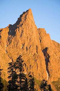
![Sunlight and Knife Point]() Knife Point and Sunlight Peak
Knife Point and Sunlight Peak![Knife Point]() Sunset on Knife Point
Sunset on Knife PointDay 2 - Climb
The alarm went off at 4am. We groaned. I find that the older I get, the enthusiasm for waking up super-early seems to be waning. After forcing down some instant oatmeal, I wandered away from camp for a call of nature, and was suddenly presented with one of the most stunning mountain scenes I had ever seen. The entire Noname drainage was laid out before me, from Animas Mountain on the right all the way around to Peak Six on the left, all bathed in early-morning, pre-dawn light. I did my best to capture the image for posterity.
![Noname Basin]() pre-dawn light
pre-dawn light
We started off with our summit packs at around 5am, and worked our way up the basin. For gear, we had one 50-meter rope, about six nuts, six cams, and six slings. We also had a cordelette and a few longer slings. We had no axes or crampons, I had trail runners on, and carried rock shoes, and Andrew wore some real boss mountaineering boots. Our packs were light, for the most part, and we made it up to what Roach calls "Jagged Pass", which is the 13,020-foot saddle north of the mountain, that separates the Noname drainage from the Sunlight drainage. En route, we passed a beautiful little lake at 12,180 feet, which Roach describes as an "idyllic campsite", but seems a bit too high and too fragile of a place to camp. We had a great view of the Animas Mountain group reflecting in the dawn light.
![Reflection]() Reflection
Reflection![North Face]() North Face
North FaceFinally at Jagged Pass, we were presented with our route, as up to this point we could not see it from Noname. It looked snowy. It looked hard. We could see the Outward Bound steps across a snowfield at the base of the harder climbing. After studying the face for a while, and comparing it to photos with a route line overlayed on it, we donned our harnesses and set out to the base of the face. I was quite nervous looking up at all the steep terrain above us. The first pitch looked snow-covered, and I was skeptical of how we were going to get up it, especially with no ice gear.
We roped up at the far side of the Outward Bound steps, and Andrew took the lead in his more-suitable footwear. At the far side of the snowfield is the first crux, a Class 4 crack and left-leaning ramp. The crack was covered in snow and ice, and the ramp was wet. Andrew boldly set forth and about fifteen minutes later was standing on the far side of the ramp. He set a good anchor and I crossed the snowslope in my running shoes, thanking every single one of those Outward Bound young-ones for their steps, as the snow was very hard, and had those steps not been there, we likely would have been shut down. After some jamming between snow and ice, hoping some ice-steps would not break, and a tentative traverse across the ball-bearing-loaded ramp, I arrived at Andrew's belay, committed to go up. Noting to Andrew that I had no desire to climb down what we had just climbed up, I told him that I had no problem leaving an enitre rack on this mountain in order to descend safely.
![1st pitch]() first crux
first cruxThe terrain above the first pitch turns into Class 2+ and Class 3 grassy steps, which proved to be very unnerving, as one of them broke away under my foot at one point. The going is steep, and the climbing is on dirt and grass almost exclusively, so it felt very unstable. Plus, whenever a rock move was encountered, my shoe soles were glazed with mud and some wetness, which made the rock uncomforting as well. We gained a lot of altitude in this section, and found ourselves at Roach's "tidy little saddle." Here we could not make sense of Roach's description. The snow gully that we needed to cross was right in front of us, for sure, but after that, all the descending and weaving around in Roach's description just didn't make sense, so we decided to just blaze straight up after crossing the snow gully. This proved to be alright, since the snow cover made our route the logical choice for the conditions. Had the route been dry, Roach's description would have fit.
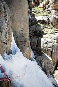
![Gully and Chockstone]() second crux
second cruxAgain, the snow in the gully was very, very hard. Andrew could not kick into it at all, so he ended up just walking on the very top part of the snow, balancing against the rock wall to the left. There was a kind of moat between the snow slope and the rock wall that made the traverse slightly less unnerving. Across the gully, Andrew surmounted a chockstone, which I read later in the summitpost route description, that the author's partner went
under the chockstone. That would be quite the tight squeeze! We then found another rappel anchor (there was one above the first crux as well), and Andrew belayed me up and over. I snapped a picture of all this when we climbed down it, as we didn't trust that rappel anchor.
Above that pitch, we zig-zagged up more grassy, gravelly ramps to the base of the crux pitch. Before we found the crux pitch we were worried about being off-route, but all the terrain around us looked harder and steeper, so we figured we couldn't be
that far off route. And we weren't. Andrew dispatched the crux pitch, which was just steep and gravelly. The rock thus far was of decidedly less quality than we were expecting. Finally we were at the notch where we cross to the south side of the mountain for the final ascent. Here the rock improved dramatically, and the climbing was enjoyable. The last Class 3 chimney/crack system was ethereal, with all the air below my feet as I was leading it. Although I think it is more like Class 4 than 3.
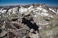
![Summit shot]() on the summit
on the summitAfter three and a half hours of climbing from Jagged Pass, we topped out. We spent a non-relaxing thirty minutes on the summit slabs, snapping pictures of the mountains around us. On top there are two modern, burly bolts for a 165-foot rappel down the north face. We decided not to do that, because a) we had only one rope b) we had no idea where the rappel would deposit us and c) it looked scary. Needless to say, we were very apprehensive about the impending descent. We knew we could rappel the crux pitch just below the notch, and the first crux, but we didn't like the looks of that anchor near the snow gully crossing (the second crux), and I was worried about downclimbing the summit pitch.
I was nominated to go second down the summit pitch, since I had my rock shoes. That chimney is quite steep, especially going down. After rappelling the crux directly below the notch, we unroped for a couple hundred feet, and then roped up again for the downclimb of the chockstone and crossing the snow gully. Andrew nicely let me go first on that downclimb, and after I was safely across that snow, I breathed a giant sigh of relief, as I knew the hardest part was behind us now. Going down those grassy steps was no picnic, and after rappelling the first pitch we still had to cross the Outward Bound snowfield. Andrew gracefully belayed me across. The snow was much softer at this point in the day, and I even punched through up to my waist at one point. But finally,
finally, we were back on solid ground, in hiking territory, after three hours of downclimbing and rappelling.
We took our time getting back to camp, stopping to get water at one point where I put my head down on a rock and fell asleep for a few mintues, even. We looked up at Peak Six and Leviathan Mountain, wondering when we might get back in there for another climb. It seems the older we get, the more complicated our lives get, and the harder it is to make time for trips like this.
My favorite thing to do in the backcountry is to stick my feet in a cold stream after a long day, so I did that once we returned to camp. It was blissful, with all the peaks surrounding us, the perfect weather, the eleven-hour day behind us, and drinking a quart of gatorade and eating a half-pound of beef jerky.
Day 3 - Return
![Sunlight Peak]() Sunlight Peak
Sunlight PeakNow with the mountain under our belt, we had only to get back to the Needleton stop by 3:45pm, and this did not seem like that hard of a task, considering what we had done the day before. Today we slept in, and rightfully so. We had some small inclination that we would get up and climb Peak Six, but of course there was no way that was going to happen. We left camp at 9am, with plans to spend a little extra time going up the middle fork of Noname, where Sunlight Peak is, just for exploration's sake. This turned out to be a nice, hour-long diversion before the long slog back to the river. And the slog wasn't even that long, it seemed. It did rain and hail a bit, once we got close to the Animas, which made the log crossing over Noname a bit tricky. Our hike back along the Animas was a bit easier, because we found a more established trail, but there was still a good amount of dead-fall, and it took the same amount of time to get from Noname Creek to Needleton as it did going up, two days prior.
We had a nice little surprise about fifteen minutes after crossing Noname Creek: we ran into the Outward Bound group again! We hadn't seen anyone else, and we were itching to tell some people about our trip, and there they were, the very people we could brag to and who would most understand what we were talking about. They were impressed that we had made the summit. We asked them about some footprints that we saw at the snow-gully crossing, and one of the leaders said that yes, that was where they turned around (only two of them went that high, just on recon). They had just returned to Needleton where they had gotten a re-supply of food from the train. It also seemed that there were fewer of them. We thought maybe that someone was moving too slow, and that they put him on the train, and ended his trip.
Then, about a half-hour later, we got another surprise: two more people heading up the trail. We thought this is crazy, after seeing no one for two days, now we run into two groups, but it turns out they were
the instructors of the Outward Bound group, a man and a woman, probably in their very early twenties. They were the ones camped in the meadow on the first day, who wouldn't wave back at us. We felt a bit stupid that when we were bragging and getting route info, it had been from
the students, who really had no mountain experience at all, for all we knew. We talked breifly to the instructors and they asked if we had summitted on Jagged and we said yes, so at least we got to tell them as well.
![D&SNGRR]() train
trainAfter arriving in Needleton, we got more evidence that the Durango & Silverton train is becoming less backpacker-friendly. In years past, whatever train came along next would pick you up, but now only the 3:45 train stops at Needleton, so when the 3 o'clock train appraoched, we were pleased that we would get back a little early, but it just rumbled past, with the other backpackers waiting and the conductor yelling at us, "45 more minutes!"
Conclusion
After a five-year build up to a climb, of course expectations are going to be high. This trip lived up to all that we had built up, all save for the quality of the climbing itself. Roach describes Jagged as being "Colorado's best peak climb." While the entire experience is definitely at the top of my list of mountain outings, for me it was not the best, but was close. Climbs of Capitol, some routes in Rocky Mountain National Park just beat it by a nose.
But what Jagged has that others do not, is a very serious, remote wilderness setting. Simply put, the mountain is
very, very far from anything. Being in the Needle Mountains (Roach calls it the "heartland") is a sublime experience, as one is completely lost in a sea of craggy peaks, like nowhere else in Colorado. Civilization is so far away, that there isn't even a hint of it anywhere. There was no register on the summit, but I gather from the amount of summitposters that have signed the log, it doesn't get climbed too often. The rappel slings were all old and dingy, so we think that we may have nabbed the season's first ascent.
Plus with the mountain having one of Colorado's hardest standard summit routes, climbing this peak brings an extreme sense of accomplishment. Andrew and I had a superb mountain experience in this area that comes close to being just about as good as anything in the state, and I would highly recommend this peak to anyone, but beware of that unnerving, loose, gravelly rock that is all over the sandy ledges. It is waiting for the unwary.
Having said all that, I still call this trip perfection for several reasons. First, the Noname drainage is bar-none the most exquisite place I have been in all of the state. The towering peaks, the rock faces, and the green meadows all combine to make it seem tailor-made. Second, the weather was perfect. Going in June has its downside of the snowpack, but we managed to deal with it, and got a little lucky (with the Outward Bound steps). The upside is that June weather tends to be rock-solid stable, before the monsoons start. Finally, what makes any trip is the company, and I've had the privledge of climbing with my good friend for eight years, and there is nothing like being in synch with your partner and having the laughs and comaraderie to break tension and propel each other to the summit.
Webshots Album
Click
here to go to an album with many more pictures from the trip.


Comments
Post a Comment