
|
|
Area/Range |
|---|---|
|
|
46.80389°N / 89.75222°W |
|
|
Hiking |
|
|
Spring, Summer, Fall, Winter |
|
|
1958 ft / 597 m |
|
|
Overview
Wilderness
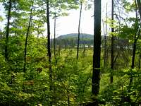
The Porcupine Mountains rise from the shore of Lake Superior in the far western Upper Peninsula of Michigan. They are not remarkably high by some standards but for this part of the midwest they represent some of the most rugged terrain around. The "Porkies," as they are known by locals, are actually a series of three ridges that lie parallel to the shoreline. The mountains are preserved within the borders of Porcupine Mountains Wilderness State Park.
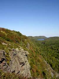
The first ridge rises 1000 feet directly from Lake Superior to a maximum elevation of around 1600 feet. The lake-side of the escarpment rises steeply but gradually while the south side is a 300-500 foot cliff overlooking the Big Carp River valley and the famous Lake of the Clouds.
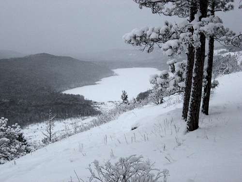
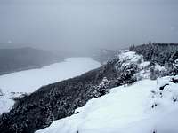
Winter On The Escarpment
The second ridge is a bit higher, reaching an elevation of 1850 feet at Government Peak. Again, the north slope of this ridge is gradual but steep. The south side however does not drop off like its neighboring ridge to the north. the two Mirror Lake sit in this high valley at about 1500 feet in elevation.
The third, and southernmost, ridge is the highest. The height of land is known as Summit Peak and it is the 3rd highest point in Michigan at 1958 feet. Climb the 50 foot observation tower at the summit, however, and you will be standing higher than even Michigan highpoint Mt. Arvon. Summit Peak does command an impressive view but does not rise from its surroundings as drastically as the ridges to the north because the terrain here averages around 1500 feet in elevation.
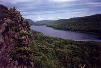
Lake of the Clouds
Gitchee Gumee
This Could Be You
Getting There
The Porkies are accessed most often from the south so that is how I'll describe how to get there. The two roads leading into the park from the south both begin off State Highway M-28. This highway runs the length of the Upper Peninsula. The majority of people entering the UP come from either Lower Michigan, through the Green Bay, Wisconsin area, or from the west (the Duluth area).
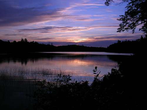
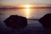
Sunset
FROM LOWER MICHIGAN: After crossing the Mackinac Bridge take the second exit past the toll booth and head west on US-2. Drive about 45 miles and turn north (right) onto M-117. You will follow this road for 13 miles until it reaches M-28. Turn left (west). It is approx. a 5 hour drive west on M-28 from this point to the east access road to the park, M-64.
FROM GREEN BAY: Head north on US-141. Follow US-141 north 160 miles until it reaches M-28 at the small crossroads town of Covington. Turn left (west) and follow M-28 53 miles to Bergland where you can turn north onto M-64 towards the parks eastern access point.
FROM DULUTH: Follow US-2 115 miles across northern Wisconsin and then 11 miles into the U.P. M-28 heads left here at the town of Wakefield. After only a mile or two you can turn north onto County Road 519 which provides access to the west side of the park.
The South Boundary Road is a narrow, winding road that serves as the only connector from one side of the park to the other.
Red Tape
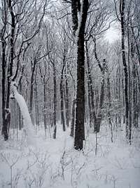
Winter is Cool
The Porcupine Mountains are located entirely within the State Park boundaries and there is an entrance fee in the form of a vehicle pass which must be purchased before entry. As of 2005 the state park pass fees were $6 for the day or $24 ($8 and $29 for non-residents). If you decide to purchase a yearly pass it is good for entry into any of Michigans State Parks. In addition to this anyone who plans on camping in the backcountry must register at the Visitors Center and pay an additional small per-night usage fee.
The trails within the park are open year-round. November 15th marks the beginning of a 16-day firearm deer season in Michigan so it is not reccomended that hikers use the trails during those times.
Also, South Boundary Road is used as a snowmobile route in the winter and as such not plowed. There are no set dates when the road is plowed until and snow can be expected anytime between mid-November and April.
When To Go
The Porcupine Mountains recieve the bulk of thier annual visitors between May and October, aka when there is no (or little) chance of snow. However, from mid-May to as late as early July you will have to deal with blackfly season, so be prepared. July and August are usually quite mild with temps in the upper 70's at inland points. Near Lake Superior the temps can be as much as 20 degrees cooler! Frosts and the color change begin in September and as the colors peak late in the month there is a small spike in visitors, but not bad. I like October for hiking because of the cool to crisp days and the extended views that the fallen foliage allow.
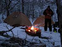
Winter is an experience unto itself. Snow usually starts falling in mid-November and is on the ground for good in mid-December. Due to the proximity of Lake Superior and the steep terrain it is not uncommon for the Porkies to see 300 inches or more of the white stuff in a winter. By late February 3 feet or more of snow usually covers the ground. Access is limited to the east and west ends of the park however so in the winter the backcountry is all that much more remote.
The Peaks
The main peaks in the park lie along the Escarpment Ridge, as well as Government Peak and Summit Peak.
The Escarpment (~1400')  |
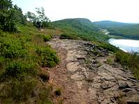
The Escarpment is easily the most popular destination in the Porkies as there is a paved road that runs along and to the top of it. It rises to a maximum elevation of about 1600 feet at Cuyahoga Peak but averages about 1400 feet. It runs for about 8 miles from one end to the other. Two trails run its length. They are the Escarpment Trail and the Big Carp River Trail. The road runs well behind and below the ridge, ending at a parking area for the immensely popular Lake of the Clouds Overlook. From this overlook the Escarpment Trail departs east for 4 miles. You can also access the trail from a number of points along the access road. The Big Carp Trail runs west for 2 scenic miles before it abruptly drops of the escarpment. You would be hard pressed to find more dramatic views in Michigan than what are afforded you from the edge of the Escarpment cliffs. The trails hug the edge for most of the way giving you outstanding views of Lake of the Clouds and the Big Carp River Valley. Blocking views farthur south, though, is the long, high ridge of Government Peak. |
Government Peak (1850')  |
Government Peak is the high point of a massive ridge that all but divides the park in two. Standing on the Escarpment the ridge blocks all views south and standing on Summit Peak it blocks all views north. Government Peak is the true "heart" of the Porkies. To reach the summit you must hike a minimum of 5.5 miles ONE WAY. The Government Peak Trail runs along the eastern half of the ridge, passing the peak along the way. It is the only trail that passes over it. The shortest route, mentioned above, is from the south via the South Mirror Lake and Government Peak Trails. The South Mirror Lake Trail is Accessed from the Summit Peak Parking Area. You can also follow the Government Peak Trail in its entirety from where it begins off M-107 (the escarpment access road). This is about a 6 mile hike. Because of its central location a number of other trails intersect the Government Peak Trail but, due to distances, would primarily be overnight routes to the summit. |
Summit Peak (1958') 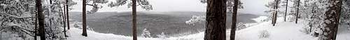 |
Summit Peak is the highest point in the Porcupine Mountains and 3rd highest in Michigan. However, it does not stand out like one may think. Rising from the surrounding 1500 foot plateau only a little more than 300 feet neither the hike up from the north or the drive up from the south could truly be classified as steep. The views from the top, with the help of a 50 foot tower, are spectacular however. The bulk of the Government Peak Ridge rises just to the north, obscuring views, but all around elsewhere stretches the forested Western Upper Peninsula. Views on a clear day are in excess of 50 miles and, even though it lacks the rugged beauty of some mountain views, the dense green canopy, unbroken by road or building is beautiful to behold. As mentioned before an access road snakes its way north from the South Boundary Road to a parking area just below the summit. The South Mirror Lake Trail descends north from the summit on its way north over the Government Peak Ridge, past Lake of the Clouds, and up the Escarpment 6 miles distant. Also descending off the summit is the 2 mile Beaver Creek Trail which joins the Little Carp River Trail 9.5 miles above its terminus at Lake Superior. |
The Grand Tour
The following is a suggested route to follow if you have a few days to spend in the Porkies and want to hit all the major peaks in the park. It is, at a minimum, a 3 day trek possibly more based on your preference. I will just include distances, you can determine the time you wish to take. Well, here goes...

-Park your vehicle at the parking area for Summit Peak. You could hit the peak right away but I suggest leaving it for the end so you can truly "climb" it and more fully appreciate the views you will take in at the top.
-Follow the Beaver Creek Trail 2.0 miles down to its intersection with the Little Carp River Trail. Turn left (south) on the Little Carp Trail.
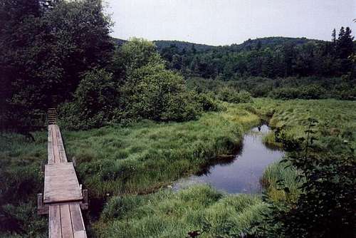
-Continue on the Little Carp Trail 9.5 miles to the shore of Lake Superior and the Lake Superior Trail. You will pass no less than six major waterfalls and countless smaller cascades as you follow the trail.
-At the lake turn right (NE) onto the Lake Superior Trail and follow it for a wooded 3 miles to where the Big Carp River Trail breaks right (SE).
Beaver Creek
-The Big Carp River Trail loosely follows its namesake river for its first 4 miles, passing a few small cascades along the way. It then hugs the base of the escarpment for 2.5 miles before a fairly strenuous climb to the top. It then follows the top of the escarpent for another 2 miles to Lake of the Clouds overlook.
-At Lake of the Cloud Overlook the trail continues east as the Escarpment Trail. This is arguably the most scenic part of the hike. Allow extra time to take in the views. The trail follows the uneven edge of the cliff passing over numerous peaks, including 1600 foot Cuyahoga Peak at about the 3 mile mark. The summit is not marked. At 4 miles the trail ends at The Government Peak Trail.
-Turn right (S) onto Government Peak Trail and you will be headed into to the most remote sections of these mountains. Along the way you will pass secluded Trap Falls, at about 2.5 miles, before the somewhat rugged climb to Government Peak itself, which is marked, at the 6 mile mark. Another 2 miles brings you down just north of Mirror Lake and the end of the Government Peak Trail at North Mirror Lake Trail. Turn left (SW).
-You will follow North Mirror Lake Trail around the quiet shores of Mirror Lake and soon becomes South Mirror Lake Trail without your knowledge. A slow but steady 2.5 mile climb brings you to where the Summit Peak Trail heads right to the summit tower of Summit Peak. From here you can take in a good portion of the park you just wandered. From here its a short half mile walk back to your car.
More Views

Waterfall
Waterfall
Camping
There are a variety of camping options in the Porkies and they are as follows:
The only modern, full-service campground is located at Union Bay at the east entrance to the park. Five more rustic to semi-modern drive-in campgrounds are located off South Boundary Road and at Presque Isle, the western entrance to the park.
[img:39103:alignright:small:5-Star Accomodations]
Within the backcountry you can choose to rent one of 16 cabins scattered across the park but reservations are reccomended WELL in advance as they are in high demand. With proper advance planning, the cabins offer you the unique opportunity to spend a number of days in the backcountry without having to pitch a tent.
Also in the backcountry are three, 3-sided Adirondack shelters or 50 backcountry campsites. Many of these have fire-rings and bear poles for your use. The shelters and campsites are available on a first-come-first-served basis however.
Your final option is to find a nice spot and pitch a tent. Trailside camping is permitted in the Porcupine Mountains except within a quarter mile of any campsite, shelter, scenic area, waterfall, or lake.
As mentioned above there is a per-day use fee for people planning to overnight in the backcountry.
BEARS: I shouldn't mention camping without mentioning bears. While quite numerous, it is unlikely you will ever come face to face with one in the Porkies. It is still highly recommended that when in the backcountry you take steps to secure your food. At shelters and established backcountry campsites bear poles are usually provided. Elsewhere find a couple trees and string your food up between them. Hang it a good 20 feet up and 10 feet out from the trees if possible and you should be OK.
Mountain Conditions
Look in the links section for webcams around the area and links to info.
The visitors Center office is open year-round for any questions you may have and can be reached by calling:
(906) 885-5275
or write:
Porcupine Mountains Wilderness State Park
412 South Boundary Rd.
Ontonagon, MI
49953
External Links
- Porcupine Mountains Wilderness State Park Official Website
The best all-around site for info concerning the Porkies. Maintained by the Michigan Department of Natural Resources. - Porcupine Mountains Chamber
Another great site for info concerning the Porkies. - Western U.P. Convention and Visitors Bureau
A good site for info about the areas surrounding the Porkies. Maps, photos, weather, trail conditions, etc. - John Dee's Snow Central
A super weather page for the Upper Peninsula. Includes snow conditions across the region, forecasts, and webcams near the Porkies and beyond! - Exploring the North Porcupine Mountain Page
A great website to get you started exploring the Porkies. Also has links to other attractions and activities in the area.
DWhike's Adventures - Shameless self promotion...come visit my website for more pics of the Porcupine Mountains and other places that I have wandered off to in recent years...
samh - Nov 14, 2008 3:20 pm - Voted 10/10
Lat/LonPlease set the correct latitude and longitude for this page.
dwhike - Nov 15, 2008 12:15 am - Hasn't voted
Re: Lat/LonDone deal, thanks for the heads up.