
-
 33748 Hits
-
 86.37% Score
-
 22 Votes
|
|
Mountain/Rock |
|---|---|
|
|
36.31761°N / 120.44835°W |
|
|
Fresno County |
|
|
Hiking, Scrambling |
|
|
Spring, Fall, Winter |
|
|
4012 ft / 1223 m |
|
|
Overview
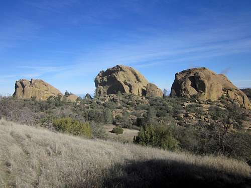
From left to right: La Piedre del Oeste, La Centinela, and La Catedral Grande
The Joaquin Rocks consist primarily of 3 large sandstone outcroppings that sit atop Joaquin Ridge in the BLM's Clear Creek Management Area of the Diablo Range, approximately 13 miles North-Northeast of the town of Coalinga, California. Visible from a busy part of Interstate 5 in Fresno County, the Joaquin Rocks are viewed by thousands everyday driving southbound, however the rocks are rarely visited due to the remoteness of their location. High clearance and 4 wheel drive is required to reach the trailhead. The rocks are then accessed by a 4.5 mile hike along a fire road that runs along Joaquin Ridge and the spine of the Diablo Range, followed by a final .5 mile singletrack trail that leads to the actual rocks.
The Joaquin Rocks are named after Joaquin Murrieta, an infamous Robin Hood-type outlaw who rustled cattle and horses in the years following the Gold Rush. Apparently, his hideout was located at Joaquin Flat, adjacent to the rocks. Joaquin Flat provided a level, sheltered, and hidden hideout amongst the seemingly endless, inhospitable chaparral-covered steep hillsides.
There are three main rocks, which all reach about 200 feet in height from base to summit. From west to east, they are La Piedra del Oeste (The Stone of the West) at 4,003 feet, La Centinela (The Sentinel) at 4,012 feet, and La Catedral Grande (The Large Cathedral) at 3,980 feet. Every rock is characterized by sheer faces on their southwest sides and smooth, low angle slabs on their northeastern sides. The northeast faces provide access to all 3 summits via class 2-3 friction scrambles.
The Vaqueros Sandstone that the rocks are consisted of is a very soft form of sandstone, easily molded by wind and water. Holds break off very easy; this makes technical climbing not a possibility at the Joaquin Rocks, even though hundreds of awesome routes would be possible, that is, if the rock was sound. There are, however, spectacular tafoni formations on the rock faces, created from millions of years of wind erosion. Deep wind and water blown depressions also exist on the slabby sides of the rocks. The summits of each rock provide superb views of a remote section of the Diablo Range. To the east, the vast San Joaquin Valley stretches 50 miles to the Sierra Nevada. One can make out semi-trucks as little dots motoring down I5.
As stated above, the Rocks are located in the southern portion of the Clear Creek Management Area (CCMA). Naturally occurring asbestos is found in the soil in much of CCMA, yet there isn't much of it around the Joaquin Rocks. The asbestos is more in the northern and central regions of CCMA.
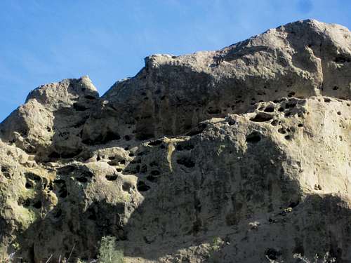
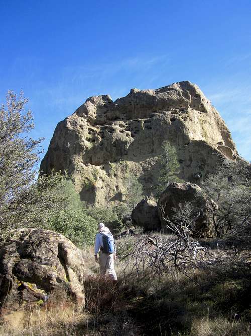
Detail of the SW face of la Centinela
Getting There
Getting to the Joaquin Rocks requires quite a long drive from anywhere, yet brings you to some of the most rugged and remote parts of the entire Coast Range. The road to the Rocks begins at the Wright Mountain trailhead, in Clear Creek Management Area. There are two ways to get to this trailhead: via Coalinga Road or via New Idria. Both routes meet up at a point north of San Benito Mountain, and then follow Road 11 in a general southeast direction to the trailhead. I've never been up via Coalinga Road, so I will describe the road via New Idria.First off, one must get to the ghost town of New Idria. Follow Matt's directions to the derelict town. As the road continues through town, it will soon begin climbing steeply up the hill. Take a left fork and drive up the very rough road. Stay on the main road (Road 11) all the way to the Wright Mountain trailhead, some 15 miles from New Idria. You will drive by the Coalinga Road cutoff, the junction for San Benito Mountain, and Spanish Lake. There are many junctions and spur roads between New Idria and Wright Mountain, yet it is mostly obvious which road is the main one. Every major junction is marked with a "Rd 11" sign, so don't be intimidated by the seemingly endless maze of dirt roads you'll see on a map. The road is quite rough, steep, and rutted in some places, so take care and drive slowly. High clearance 4 wheel is required from about 1/2 mile out of New Idria onward. Since the BLM closure of Clear Creek, the roads have not been maintained, so obstructions may exist on roads. Be prepared for downed trees, boulders, washouts, etc. Road 11 would be considered a 5 on this scale.
Park at the large saddle between Wright Mountain and a smaller knoll to the east. Hike up the road, past the gate, and go about 4.5 miles to the small, unsigned Joaquin Rocks trail. The trail is pretty nondescript. About 1/2 mile after passing underneath a large rock outcropping (Joaquin 2 BM), look for the trail leaving the road up the hillside on your left. Take this trail to the ridge where you will have your first view of the Rocks. Follow the trail across Joaquin Flat, between La Piedra del Oeste and La Centinela where the trail splits into a couple little use trails that lead to the base of each rock.
Click here for a TOPO! map of the route, courtesy of Bob Burd.
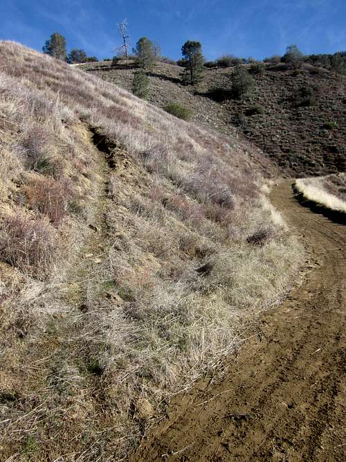
Trail Junction
La Piedra del Oeste
Base of La Piedre del Oeste.
La Piedra del Oeste is the western-most rock and the most massive, but not the tallest. It is the least steep of the three. Getting on top of it requires a short little bushwhack down the creek that runs down its southeast base. There are a couple summits very similar in height at the top, along with many wind eroded depressions. It's a class 2 scramble up La Piedra del Oeste.
Summit
La Centinela
La Centinela
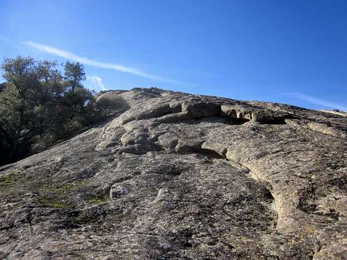
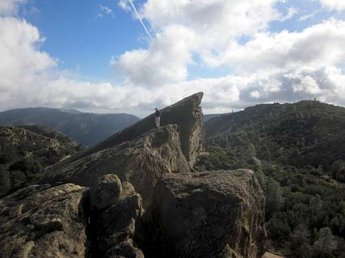
La Centinela is the middle and tallest of the Joaquin Rocks. Its sheer 200 feet face is clearly visible when hiking across Joaquin Flat. Follow the main trail around the northwest side of the monolith and it will lead you around to the northeast slab. Scramble up the massive slab, which can be anything from class 2 to class 3 friction. There is a very faint worn "trail" up the middle of the slab where most people have ascended. Watch out for the "Bottomless Pit" near the summit, a very large, wind carved depression, nearly 20 feet deep. The top of the La Centinela provides nice views of the adjacent rocks.
La Catedral Grande
"The Large Cathedral" is the most eastern, steepest, and smallest of the rocks. It's also the hardest to surmount. The northeast slab is steeper than the slabs of the other two rocks, mostly class 3, and can be slick due to a higher presence of moss. The summit is thin and airy.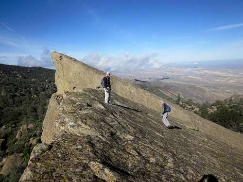
Summit of La Catedral Grande
Red Tape
From 2008 until 2014, the Clear Creek Management Area was under a temporary "closure", authorized by the BLM. This closure was not very well enforced, but has now been lifted. Permits are required to enter the Management Area, which can be obtained here. See informative comment by user davidsanger in the "Additions" section.Camping is possible at the Joaquin Rocks or at the trailhead, yet take note that there is very little water available anywhere in this area.
When to Visit.
The Joaquin Rocks are best visited in fall, winter, or spring not after a heavy rainfall. The road to the trailhead will become impassable immediately after a heavy rainstorm.Summer heat should discourage anyone from going to the Joaquin Rocks, unless one is a complete masochist. 100 degree temperatures, no water or shade, and an abundance of rattlesnakes and ticks are all to be expected. Also, the soil in CCMA is more "toxic" during the summer because it is drier; the dusty serpentine soil containing the asbestos can kick up easily in wind and become easy to breathe in. In the winter, the soil is wet and compact.
davidsanger - Mar 12, 2015 11:24 pm - Hasn't voted
Now openAs of March 2014 the Clear Creek Management Area is open to the public but access to the the central area, the Serpentine ACEC, where San Benito Mountain is, is through a locked gate. The road from Clear Creek (form the Hollister/Coalinga Road on the west side) is quite good now, though with a couple of stream crossings on concrete fords. You have to get permits online (one for your car, one for each person). Then you have to telephone the BLM office in Hollister for the gate key combination details at BLM site http://www.blm.gov/ca/st/en/fo/hollister/recreation/clear_creek_recreation.html and to buy permits at recreation,gov :: http://1.usa.gov/10F4zDX
McCannster - Mar 13, 2015 9:59 am - Hasn't voted
Re: Now openAwesome news David, thanks for posting. A permit system for this area is a really good idea, IMO, the CC Mangmt Area had been "closed" for far too long. I will update the page once I get a few minutes.