
-
 10019 Hits
-
 85.35% Score
-
 20 Votes
|
|
Mountain/Rock |
|---|---|
|
|
45.45400°N / 113.738°W |
|
|
Beaverhead |
|
|
Hiking, Bouldering, Scrambling |
|
|
Summer, Fall |
|
|
9723 ft / 2964 m |
|
|
Overview
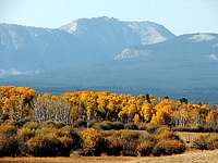
Jumbo Mountain 9723' literally stands alone as a Beaverhead summit. Jumbo rises 2000' from two timber rich valleys and has no connecting ridges with any of the neighboring peaks. If you approach Jumbo from the east it quickly becomes apparent how this mountain got its name with Jumbo's big, bulky frame staring at you.The upper meadow terrain circling Jumbo's west end certainly has 'the last best place' feel to it. In addition, the west ridge offers good scrambling to satisfy your need to have 'earned' your summit.
William Clark and his company of men made their way through the Big Hole Valley in 1806 on their way back east to meet up with Meriwether Lewis. In addition there were fur trappers in the Jumbo Mountain area in the 1830's.
This particular area seems to have escaped the touch of mining interests and fire giving Jumbo
and it's surroundings the raw look it had two hundred years ago.
Alpine meadows, pristine forests, and an untouched landscape makes Jumbo a summit worth pursuing.
 Jumbo Mountain
Getting There
Idaho approachFrom US 93 take Fourth of July Creek Road which is about 6 miles south of North Fork. Mile marker 321 is right at the turn off.
Travel 10.5 miles and take an obvious right at the 7520' spot elevation which is shown on the topo maps. Just beyond this turn is an excellent reader board with a map showing your location. From the turn travel just under one mile and park below the steep kick up. The trail starts here and begins as the road fork that goes off to your left. There is an old prospectors cabin straight ahead at the top of the steep kick up. If you find yourself at the cabin, you are at the wrong starting point.
2WD all the way. There are a couple of mud holes in the last mile that could cause some trouble. The last 1/2 mile of road is on an east side ridge and in the timber, thus it may hold snow longer early in the season.
Montana approach
Take the Twin Lakes campground exit which is 6.6 miles south of Wisdom on Hwy 278. Travel 8.2 miles to the sign which points south to Big Swamp Creek Road. Do not turn south but proceed straight ahead under the log arch which says Sunnyslope on it. The Wisdom Ranger District has told me that this is public access although it looks like a private ranch.
I have not traveled beyond this point and a call to the Wisdom Ranger District might be the best option to ascertain the layout of the road system and to determine an appropriate starting point. Otherwise check out your topo maps and give it a go.
 Jumbo Mountain
 Jumbo Mountain
Summit Routes
West ridge Class 3From Idaho
Follow the road fork off to your left. This ATV road will eventually end, but as it does the Continental Divide Trail appears and you can follow this blazed trail up into the basin. On the return this ATV road can be tough to pick up from the CDT, so take appropriate measures.
Pick your best spot to leave the CDT and go cross country headed for the saddle between Pyramid Peak and Peak 9681. Gain the saddle, drop into the basin below Jumbo, and head straight for the west ridge.
There are a handful of rock towers on the ridge and one prominent notch just before the summit. The notch is probably Class 5. They can all be bypassed by staying to the south side of the ridge.
The crux appears within 100' of the summit with some rock ribs and a rock gully which all need to be navigated to gain the summit. Once again, stay to the south side to bypass all obstacles.
Starting elevation: 7700'
Round trip elevation gain: 3000'
Round trip distance: 8-9 miles
 West ridge final obstacles
East ridge Class 2
From Montana
This is a forested traverse up onto the east ridge and then a straight forward ascent to the summit. I could see no obstacles on this route.
 Jumbo Mountain
 Jumbo Mountain's east ridge
Camping
IdahoOption 1 - Just beyond the last private residence on Fourth of July Creek Road there are numerous informal camping sites available. They are spread out over a two mile stretch and used primarily as hunting camps in the fall.
Option 2 - On the last mile to the trailhead, there are several vehicle turnouts where you could set up camp. One prominent turnout sits up high and affords an excellent view of Pyramid Peak and Peak 9681.
Option 3 - Wagonhammer RV Park and Campground is located three miles north of Fourth of July Creek Road on US 93. Wagonhammer Campground
Montana
The closest USFS campground is Twin Lakes. However, it does lie a bit beyond your objective. As with much of the West Big Hole, you can probably drive to near your starting point and set up camp at a place of your choosing.
Summit Views
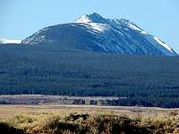
 Sheep Mountain
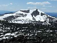 Pyramid Peak
Red Tape
There are no obstacles for travel or camping from either state.When to Climb
June through October.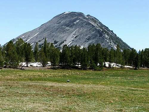 Typical basin terrain
Area Administrators
North Fork Ranger District11 Casey Rd.
PO Box 180 Hwy 93 North
North Fork, Idaho 83466
208-865-2700
Wisdom Ranger District
PO Box 238
Wisdom, Montana 59761
406-689-3243