
-
 18095 Hits
-
 86.97% Score
-
 24 Votes
|
|
Mountain/Rock |
|---|---|
|
|
44.33957°N / 112.85156°W |
|
|
Lemhi, Beaverhead |
|
|
Hiking, Bouldering, Scrambling |
|
|
Summer, Fall |
|
|
10998 ft / 3352 m |
|
|
Overview
This southern Beaverhead peak lies just to the north of Scott Peak 11393' and Huhs Horn 11292'. As stated in Tom Lopez' Idaho A Climbing Guide, Italian Peak is a masterpiece of unforgiving talus slopes capped by two summits along a broken ridge line.The west summit is Class 2 and is essentially a high point as you top out on the ridge.
The east summit is Class 4 and separated from the west summit by a notch in the ridge.
I would concur with Lopez' guidebook as the east summit does appear to be higher. Additional details on the Class 4 east summit can be found in the Lopez Guidebook section.
 Italian Peak
As with most high summits you get an excellent view of this isolated country. The Lemhi Range stretches out along the western horizon anchored by Diamond Peak and Bell Mountain. Some of the more remote and unnamed 10000' Beaverhead summits on the Montana side offer rare glimpses. Photos of these can be seen below in the Mountain Gallery section.
Although Italian Peak may not be the main objective that Scott Peak, Huhs Horn, or the Clark County highpoints are, it still provides the mountain experience that we all eagerly pursue.
Getting There
IDAHOFrom Hwy 28 take the Nicholia Road headed toward the Nicholia Ranch. Nicholia Road is near mile marker 58. Travel 3 miles and take a right as you reach the foothills.
Follow this main track for 5 miles to the Scott Canyon Road. The road curves to the left into the canyon and does have a sign. From here it is about 4 miles to the final gate which restricts motorized vehicle use.
MONTANA
These will be some very general directions with which you will have to negotiate your own jumping off point. With some topo maps, some planning, and maybe a little 4WD, you should be able to piece together a starting point.
From I-15 take Exit 23 at Dell and work your way toward the Harkness Lakes via Big Sheep Creek Road. Plan on roughly 30 miles of driving before reaching your best place to start.
Or take Exit 15 at Lima and work your way in as close as you can get.
Summit Routes
IDAHO Talus slopes
From the gate, follow the trail up Scott Canyon. The first side canyon that you come to on your left is marked with a sign as Trail 081. Follow Trail 081 up through the canyon. Higher up, the trail crosses a small boulder field and makes a noticeable left into the tree covered hillside. At this point Italian Peak is clearly visible on your right, so leave the trail and continue on to the west saddle below Point 10081. Turn to the right and head for the west summit.
If you love miserable talus, disregard the following. I suspect that most get to a point before the west saddle (as I did) and decide it is shorter to cut and work up the face of Italian Peak. Those who do, soon find themselves in an all fours talus slug fest, scrambling for any purchase you can find, and screaming for mercy.
It is faster to hit the west saddle, where you will find a well worn, but manageable talus trail leading all the way up to the west summit.
MONTANA
Again, these will be some very general directions. According to Pat Caffrey's 'Climbers Guide to Montan', gain the northwest ridge from the Nicholia Creek Trail. Yes, Nicholia shows up in both states.
More importantly, I could see the CDT running below Italian Peak. I suspect that if you can get on the CDT, it will take you to a jumping off point for the northwest ridge. Caffrey rates this: S - a Class 3 scramble.
Caffrey's guidebook was published in 1986, before the CDT was a reality, so it is possible that the Nicholia Creek Trail and the CDT are now one and the same.
Options
 Tuscany Peak 10776'
TUSCANY PEAK 10776'
This unofficially named summit lies 1.2 miles northwest of Italian Peak. Follow the divide to this summit. Expect some side hill traversing in places if ridge top travel is not feasible. Expect some Class 3 on the final summit section.
 Indian Head Peak 10001'
INDIAN HEAD PEAK 10001'
This unofficially named summit rises on the south side of Scott Canyon. If camping in Scott Canyon for the night, this is a good evening climb and also an excellent platform for taking photos of Italian Peak, Huhs Horn, and Scott Peak. Pick your best starting point.
Rick Baugher is credited with the first ascent and naming of the peak. His 1996 signature was the only one in a film canister wrapped in two zip lock bags. I will just have to settle for a second ascent.
THE HEEL 9703'
This is another Baugher special which rises on the north side of Scott Canyon and is also a good evening outing if camping overnight in Scott Canyon. Pick your best starting point.
As with Indian Head Peak, Rick Baugher is credited with the first ascent and naming of the peak.
You can check out more on Indian Head Peak and The Heel at Climbing Idaho.
Lopez Guidebook
 Italian's west summit
TEXT CORRECTIONS
The description on Italian Peak does have some errors in the text where the words east and west have been inserted in the wrong spot. The corrections should read:
The good news is that the lower west summit is only Class 2.
The bad news is that the slightly higher east summit is Class 4 . . .
More bad news, the route up the southwest ridge to the west summit . . .
EAST SUMMIT CLASS 4
The route description given in Lopez' guidebook cannot be completely observed from the west summit, but I don't doubt that it is accurate. The second option that looked viable was straight across the ridge and it had at least two sections of Class 4 to negotiate and honestly, I quickly decided to stay put. This option as well could not be 100% visually scouted as the notch is obscured until you are committed on the route.
 Scott Peak, Huhs Horn, Italian's east summit
There was no place to traverse lower on the Montana side to avoid the ridge or avoid the Lopez route.
The photo in the guidebook is a little deceiving as the two summits are actually much closer together than what it appears from the photo. Even with the Class 4 that is involved, roughly 15 minutes to do the traverse.
The Lopez route has a 186 word description on how to gain the east summit. For the non-Idaho crew, here is a condensed version.
Descend to the notch staying to the southwest side. Continue to descend to a talus covered shelf. As the shelf turns a corner, a 60' chimney appears. This is the crux. Stay in the chimney for the first 30' then move to your right onto the face for the final 30'. Above the chimney, climb a sketchy talus slope to a north oriented gully. This gully has loose handholds, but once ascended will leave a short stroll to the summit.
August 9 Storm
This was the southern perimeter of a storm system that poured over the Lemhi Range on the drive out from the Beaverheads. That is Bell Mountain on the far left, uniquely dwarfed by the system.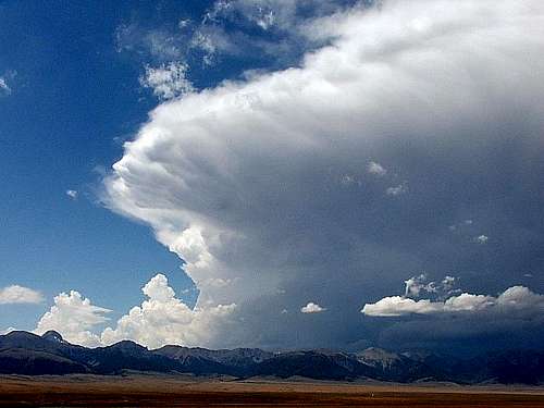 August storm system
On this day 8/9/2008, the National Weather Service issued a severe thunderstorm warning with dangerous cloud to ground lightning for Custer County. Borah Peak and the Lost River Range are located in Custer County which is the next range to the west of the Lemhi Range.
People were advised to get indoors, stay away from windows, and ride it out. Some research on this storm revealed that people on Borah were screaming with panic and bailing off Idaho's tallest as fast as they could go.
Mountain Gallery
Officially, the following summits are all unnamed. However, as is the case with many mountains, the climbing community or the locals attach a name and it sticks. The unofficial name is shown in the caption. All can be checked out in the Peaks section at Climbing Idaho. Acropolis Peak 10821'
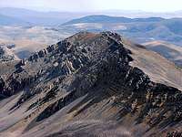 Cul-de-Sac 10529'
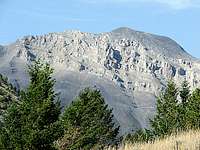 Huhs Horn 11292'
 Sunny South 10601'
Camping
IDAHOCar, tent, and even trailer camping can be done right at the final gate in Scott Canyon. Although there are no restroom facilities, there is more than enough room and plenty of level ground.
MONTANA
This is wide open country and you can set up camp just about anywhere. The CDT runs through this area so it is normal for CDT 'thru' hikers to camp wherever they choose.