Overview
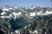
Kangaroo Ridge is a three-mile long N/S ridge, located E of the
Liberty Bell Group and SW of the
Silver Star Group. Kangaroo Ridge provides an interesting variety of summits and climbing opportunities but unlike it's more famous neighbors to the W and to the NE is visited less often. With Hwy 20 below and visible from many of the summits (on the ridge) the sense of solitude is imperfect but because of the lack of competing climbing parties for routes in the area you can still achieve a sense of adventure and can perhaps experience something akin that which the pioneering climbers, of the area, experienced themselves.
The rock on most of Kangaroo Ridge tends to be eroded and granular down low (especially on the W side) but of better climbing quality up high. The approaches to some climbs (especially on the N end of the ridge) involve much scree work when the early season snow cover has melted off. In
Eric Sandbo's proposed new guide-book
"North American Screeing" Kangaroo Ridge fills an important chapter. The short approaches to and relatively short routes on most of the Kangaroo Ridge peaks means large climbing racks and excessive gear packs aren't needed.
Fred Beckey states in his
"Cascade Alpine Guide - Rainy Pass" that through his diligent search of Forest Service and other records he was unable to find the origins of such colorful names as Kangaroo Ridge, Silver Star and Liberty Bell but that the name was mentioned on Forest Service maps as early as 1926. Eric has mentioned that "Somebody saw this long ridge with fairly evenly-spaced peaks on it and remarked that they were like the hops of a kangaroo." Whatever the origin of the name, it does add some color to this interesting ridge of peaks and peaklets.
Summits
Named summits: Some of the
unofficial names for the peaks and features along the ridge, starting from the North include; Joey, Mushroom Tower,
Big Kangaroo, Melted Tower,
Half Moon, Choi Oi and Hai Towers, Wallaby, Little Finger, Kangaroo Temple, The Platypus, The Tomahawk and The Fin.
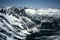
Approach
The preferred approach involves driving WA State Hwy 20, either from the East or the West, to approximate Milepost 163. There is a large pullout at the Hairpin turn, directly below and E of the SEWS, this is the parking area. Two seldom used alternatives include: Cedar Creek trail
#476 leaves Hwy 20 near MP 175 and provides a 9+ mile hike on the E side of the ridge. Twisp River Road (
FS Map) provides access to the S side of the ridge, for the adventurous, over old (
#426 &
#432)and seldom used trails.
Red Tape
Kangaroo Pass is on the N border of the Lake Chelan / Sawtooth Wilderness area. Check with the Okanogon National Forest for rules and regulations pertaining to parking, camping and wilderness travel here,
Okanogon National Forest.
Mountain Conditions
Check wih
NOAA, for current weather conditions.
Check with NWAC.US
here or
here (text) for avalanche conditions.

 23929 Hits
 80.85% Score
 13 Votes