


-
 92766 Hits
-
 99.07% Score
-
 97 Votes
|
|
Area/Range |
|---|---|
|
|
48.67961°N / 121.33725°W |
|
|
Hiking, Mountaineering |
|
|
Spring, Summer, Fall, Winter |
|
|
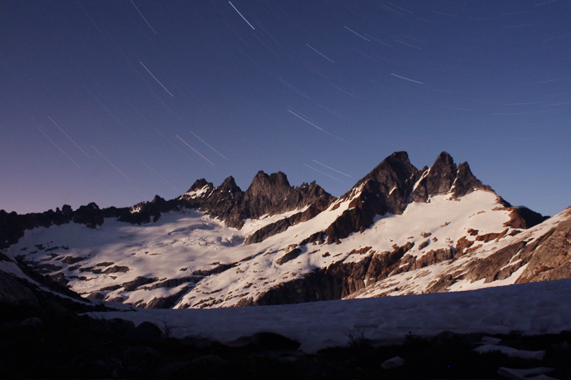
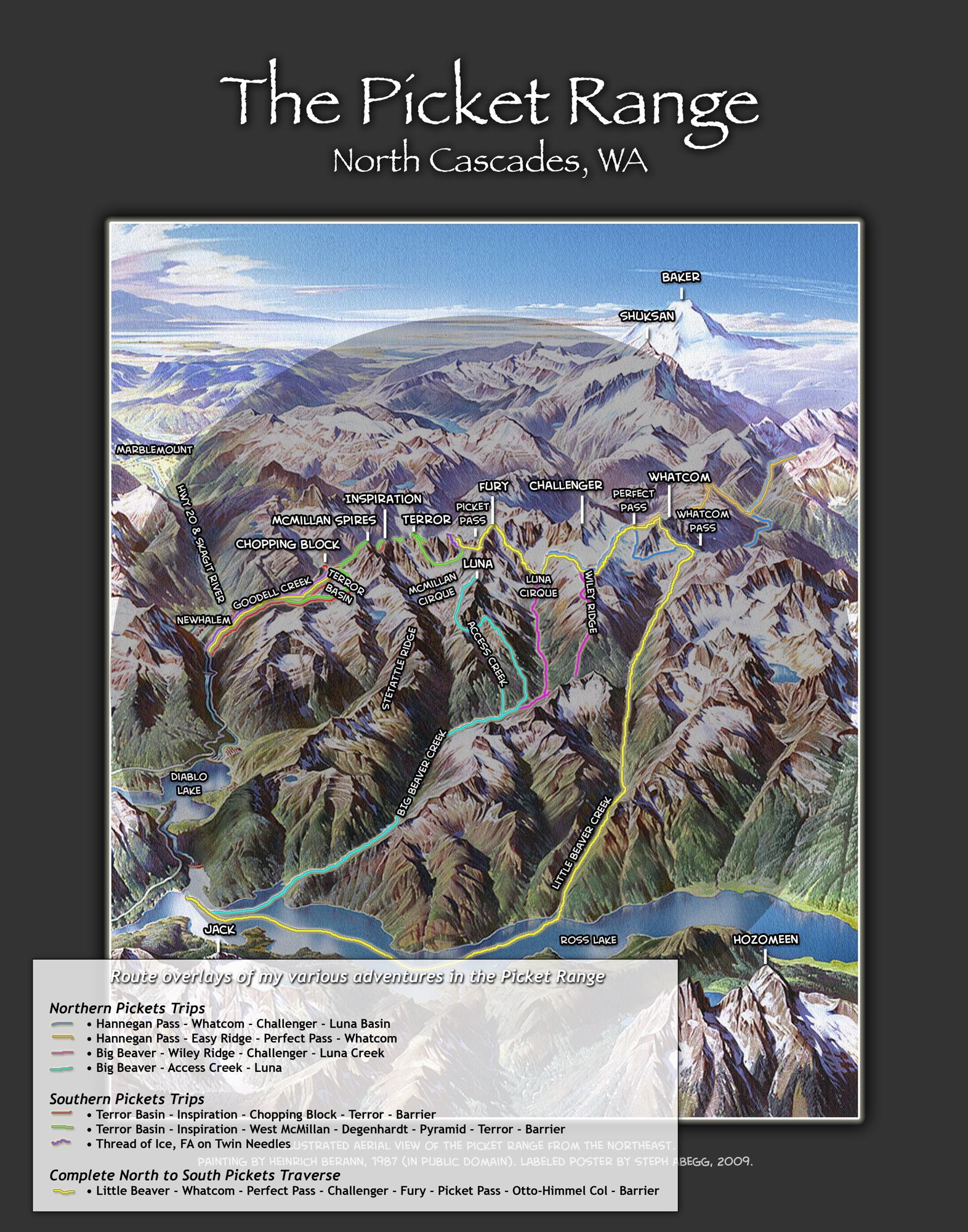
| The Picket Range The most rugged terrain of the North Cascades, Washington  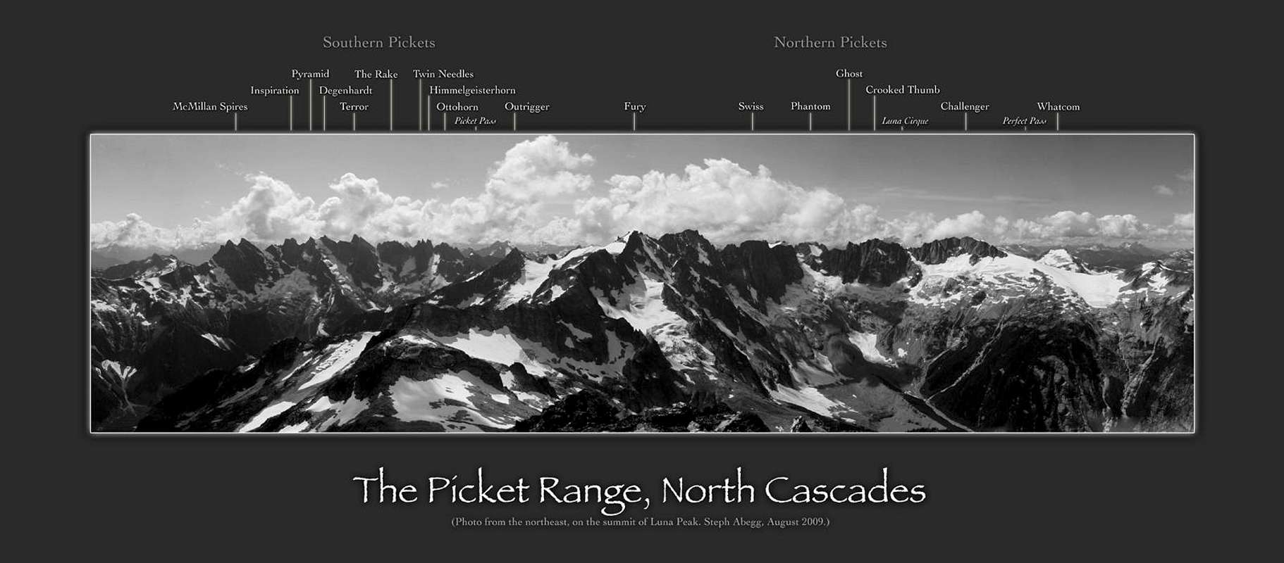 Because of its rugged terrain, the Picket Range has remained the wildest and most unexplored region in the North Cascades. Its isolated brushy valleys, jagged ridges, long and steep climbs on mixed terrain, and variable conditions present an array of mountaineering challenges and spectacular scenery. It is the challenge and ruggedness that are the essence of the Pickets, and keep me coming back time and time again. This page describes the various summits and routes in the Pickets, details approach routes, gives tantalizing photos, and provides links to my trip reports for my many adventures in the Pickets. I also have this information on my website's Pickets Page, which might be kept more up-to-date than the following page. On this page, sections are color-coded by: green for Northern Pickets, blue for Southern Pickets, and grey for both ranges. This page was initially created by Michael Stanton, and I have kept much of his text, such as for the approach beta. The super-spiffy maps and profiles on this page are by Mark Thomas. Thanks Mark! Disclaimer: Due to the rugged and committing nature of the Picket Range, they are a place for experienced and confident alpinists. The Pickets not a good place to start off your mountaineering career. |
|
| The Northern and the Southern Pickets |
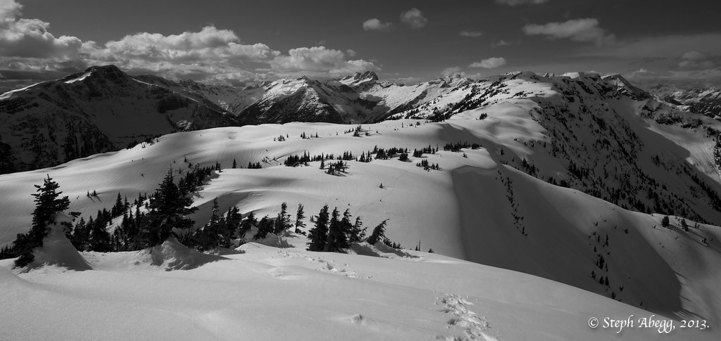
The Pickets can be divided into a southern half and a northern half. The panorama below—taken from the summit of Bacon Peak in the North Cascades—captures the entire range, with the Northern Pickets on the left and Southern on the right. The major summits in each range are listed in this section.
 |
|
| ||||
| The Northern Pickets form a "C", with Mount Challenger and its large glacier in the north, sweeping down on a continuous ridge to the south and then east to Mount Fury, and then Luna Peak as the eastern terminus. While the Northern Pickets are not as jagged as their Southern counterparts, they are perhaps even more difficult to access and equally rugged to surmount. From east to west:
1. Luna Peak (8311 ft) * 2. Mount Fury (8280 ft) * 3. Swiss Peak (7988 ft) * 4. Phantom Peak (8000 ft) 5. Ghost Peak (8000 ft) 6. Crooked Thumb (8124 ft) 7. Mount Challenger (8207 ft) * * MAP of the Northern Summits  | The Southern Range is noted for slender spires of rock rising above small glaciers on the southern slopes, and is visible from the North Cascades visitor center in Newhalem. The northern walls of the Southern Range are truly awe-inspiring. The basin defined by these walls is one of the most remote places in the continental U.S. From east to west:
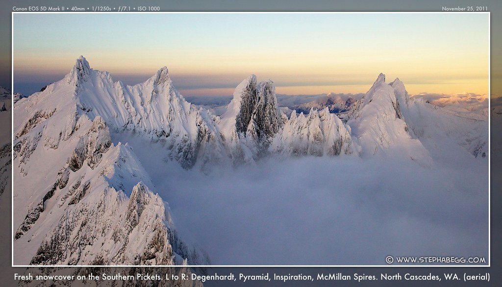
8. West McMillan Spire (8000 ft) * 9. East McMillan Spire and Little Mac Spire (7992 ft) 10. Inspiration Peak (7880 ft) * * 11. The Pyramid (7920 ft) * 12. Mount Degenhardt (8000 ft) * 13. The Chopping Block (aka Pinnacle Peak) (6819 ft) * 14. Mt. Terror (8151 ft) * * 15. The Rake (The Blob) (7840 ft) 16. Twin Needles (7936 ft) * 17. Himmelgeister*horn (7880 ft) 18. Ottohorn (7840 ft) 19. Frenzel Spitz (7440 ft) (*Most people know this elusive Pickets summit by Himmelhorn—German for "Horn of the sky"—but it was originally named Himmelgeisterhorn—"Horn of the Sky Spirit"; so shortening the name literally takes the spirit of the name away!) MAP of the Southern Summits  |
| The Classic Climbs |
A set of climbs has emerged as the "must do" list of the range. That said, almost any climb in the Pickets is worthy due to the challenge and sheer beauty of the area.
| | In the Northern Pickets |
 |   |  |
| North Buttress or the Southeast Glacier, in the heart of the Pickets. | Challenger Glacier route, a true North Cascades classic glacier and rock climb. | Southwest Ridge, a straightforward scramble with an unbeatable summit view of the entire Picket Range. |
| | In the Southern Pickets |
 |  |  |
| North Buttress and Stoddard Buttress, one of the most rugged north faces in the Cascades. | West Ridge, a straightforward scramble in the Southern Pickets. | West Ridge, East Ridge, AND South Face, all steep and fun technical rock climbs. |
| Approaches |
 |  |   |
| The location of the Pickets. Only 2.5 hours (120 road miles) from Seattle! | The seven most used approaches into the Pickets. Each numbered approach is described below. | Northern and Southern. |
"For future alpinists, [Henry] Custer counseled, 'Always select, the longest leading spur ... Never select a ravine or watercourse, coming from the peak to be ascended, if you follow one of these, you will find many difficulties, in your way, consisting of sudden drops, dense brush, and dense vegetation.'"
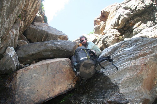
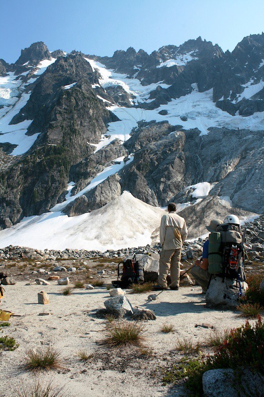
There is no easy way into the Pickets. Nearly every approach into the Pickets involves its share of sweating, vegetable belaying, and cursing. But it is always worth the effort, and the difficult approaches and rugged terrain is part of what makes the Pickets so special.
There are 7 main approach routes into the Pickets, numbered in the map above (note that there might be other ways besides these 7 routes to get into and out of the Pickets, these are just the ones that have been the most used over the years). These approach routes also serve as the exit routes. I have done 6 of them, as well as pioneered two other routes I wouldn't recommend unless you crave bushwhacking and treacherous wet cliffs. I'll do my best to give sufficient detail for the 7 main approaches, but for planning a trip into the Pickets, it would be foolhardy to go without Beckey's Cascade Alpine Guide Volume 3 or Tabor and Crowder's Routes and Rocks in the Mt. Challenger Quadrangle. There are many pages of detail on these approaches (and exits) into (and out of) the Picket Range.
Any entrance-exit pairing is possible for the approach routes described in this section. The section after this (Section 4) gives some popular traverses between the various approach routes. One thing to consider when planning an entry and exit route into the Pickets is the road distance between the trailheads. All but one of the routes into the Northern Pickets start at Ross Lake (with a possible water taxi), while the routes into the Southern Pickets start at Goodell Creek trailhead or Diablo (Stetattle Creek). All of these trailheads are within 20 miles along the North Cascades HWY, so it is feasible to enter via one and exit via the other. However, if the plan is to enter via Easy Ridge, then a 2-hour car plant is in order (or, a clever trick is to meet friends who came from the opposite direction and exchange car keys midway).
 |  |    |
| Approaches (and Exits) of the Northern Pickets |
There are four main approach (or exit) routes for the Northern Pickets. (Of course there are always other creative approach options, but most that I can think of come up some obscure creek valley or ridge and would involve a lot of 'shwacking and car plant problems.) The numbers on the following approaches correlate with the maps on this page.
- APPROACH 1: Easy Ridge to Perfect Pass
- APPROACH 2: Little Beaver Creek to Whatcom Pass and over (or around) Whatcom Peak
- APPROACH 3: Big Beaver Creek to Wiley Ridge
- APPROACH 4: Big Beaver Creek to Access Creek
| | APPROACH 1: Easy Ridge to Perfect Pass |
 |  |
| | |
This is a popular way to get to Mount Challenger. The advantage of the Easy Ridge approach is that there is not too much bushwhacking, and you have a scenic walk along the spine of Easy Ridge. The three disadvantages are: (1) the Hannigan Pass trailhead is a long drive from any other approach route into the Pickets, (2) it is a rather long approach with ups and downs, and (3) the Perfect Impass (aka Imperfect Impasse) shortly below Perfect Pass is a perplexing feature, sometimes easy walked across on snow, other times requiring a long detour down and back up through brutish brush. When I did this approach in 2005, we opted the detour down and around the Impasse. When I did the Easy Ridge approach in 2005, we opted the detour down and around the Impasse; but when I returned to the area in 2012 (this time using the Easy Ridge route as an exit route), I did indeed do the Impasse and I have included some photos at the end of this section.
To get to the Hannegan Pass trailhead drive the Nooksack River road to a left turn on road FR 402. The trailhead is at 3100 feet, starting from a large parking lot at the end of the 4 mile long road.
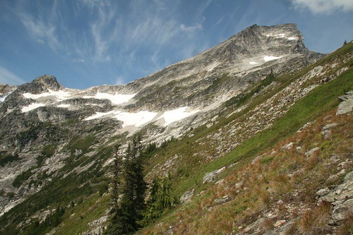
From Hannegan Pass, you can descend to Copper Creek Camp above the Chilliwack River at about 3200 feet (marked as "campsite" on USGS map). This is a good strategy if you came in Friday evening and want to make it to Perfect Pass Saturday night. From the campsite hike two more miles, then start looking for an unmarked trail descending a little bit to the river. You'll ford the river here and find the Easy Ridge Trail on the other side. At first, the trail is pretty brushy and you'll get wet from dew in the morning. Eventually it starts climbing steeply as it works from 2800 feet up to 5000 feet, where you leave deep forest and enter huckleberry bushes at a pass on the ridge. Congratulations, now you can enjoy the scenery!
You'll follow the ridge to Easy Peak (6615 ft) in beautiful terrain. After Easy Peak, travel east on the ridge until walls of Whatcom Peak begin to loom. Drop gently down from the ridge in grassy terrain heading southeast. You'll want to lose about 1000 feet, dropping from about 6200 ft to 5200 ft to get to the base of a buttress of Whatcom where an imposing sight will greet you: the Imperfect Impasse.
Going early in the year you may barely notice the Impasse: just walk across what is actually a very deep gorge on snow. But when it melts out there is no easy entrance or exit. Climbers have climbed in and above the gorge to find a way across, but it has "terrifying exposure" as one climber noted; at a minimum, be prepared to get the rope out, but also know there is little protection on the slabby terrain.
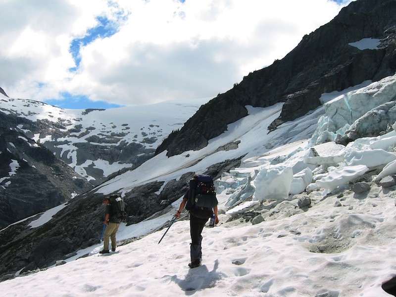
To avoid the Impasse, as I did in 2005, you can descend (another) 1000 feet or so until the gorge ends and you can walk easily across the stream. On the other side grimace and enter the brush and start climbing back up. If benighted, there is a flat spot on the west side of the gorge for a camp. You'll climb up through thick brush and slabs until the way eases below Perfect Pass (6200 feet). Great camping is available here on the edge of the Challenger Glacier.
(To climb Challenger from here, just drop down onto the glacier—there are a few options, depending on conditions—and traverse across the large glacier to the saddle below Challenger Arm. Then, climb up Challenger Arm. Although the approach up the arm is an easy hike up snow, in the last few years, a gaping bergschrund just below the summit has turned around many parties. There is almost always a way around if you detour to the leftmost ridge, but sometimes this can be tricky as well. Once you have surmounted this obstacle, the final climb to the summit involves a 50 foot fun rock corner (5.5). Usually it is sufficient to have a rope and a few slings to clip to the 3 fixed pitons. Most parties take a couple of hours from the base of Challenger Arm.)
 |   |  | |
| | APPROACH 2: Little Beaver Creek to Whatcom Pass and over (or around) Whatcom Peak |
 |  |  |
| | | |
This is the only approach into the Pickets that lacks bushwhacking altogether. The main disadvantage is that it begins with a somewhat long slog along a trail.
Getting to the Little Beaver trailhead requires a water taxi across Ross Lake. (Unlike the Big Beaver approach described below, a water taxi is necessary in the Little Beaver approach as there is no trail that goes this far around the lake.) Information about fares and booking a water taxi ride can be found on the website for Ross Lake Resort; as of 2011, the water taxi to Little Beaver trailhead is $125 per party. Ross Lake is easy to find along the North Cascades HWY. The water taxi dock is a downhill 0.8 mile hike from the parking lot.
Once at the Little Beaver trailhead, it is about 18 easy trail miles to Whatcom Pass. Usually, parties camp at Twin Rocks camp about 14 miles along the trail before tackling the 2200ft of elevation gain to Whatcom Pass the next day. From Whatcom Pass, head east (left) along a climbers towards the obvious Whatcom Peak, which you will have to climb over. The trail soon peters out, but the going is easy (Class 3). Just keep heading up towards the summit on the north ridge, and below the summit head to the south side of the peak to gain the saddle. From here, you can look down at Perfect Pass (obvious heather-covered saddle below) and you can easily scramble up the final couple of hundred feet to the summit of Whatcom Peak. If there is good snow, the descent down the south side of Whatcom Peak towards Perfect Pass takes all of 10 minutes. In the late season, this might take a bit longer.
(In 2002, instead of going over the easy north side of Whatcom Peak, my dad and I contoured the peak via the Whatcom Glacier. This route is described in Tabor and Crowder's Routes and Rocks in the Mt. Challenger Quadrangle. There are some nice slabs below the glacier which offer a feasible crossing. However, at least in 2002, the Whatcom Glacier is experiencing a process of rapid shrinking, and frequently large chunks of ice go careening onto the slabs below the glacier. My dad and I were actually walking right underneath a truck-sized ice chunk when it slid off; had it had just a few extra feet to pick up speed before it hit us, we would have been swept off the mountain with it. We were quite lucky as it was to not be injured. So, I'm not sure I would recommend the Whatcom Glacier as a route, but it is a possible line of approach; at some point—perhaps even by now—most of the ice chunks will have slid off, opening up nice slabs that are no longer as hazardous to cross.)
Perfect Pass lives up to its name. Granite slabs interspersed with heather and streams make it a beautiful place to spend an afternoon. From the pass, you can enjoy a sunset over the Pacific, or gaze upon the vast expanse of the Challenger Glacier. This is one of my favorite sunset--viewing spots in the Cascades.
 |  |
| | APPROACH 3: Big Beaver Creek to Wiley Ridge |
| |  |  |
| | | |
This is probably the most frequented approach to Mt. Challenger, for whatever reason. Usually, enthusiasm to get into the Pickets will inspire the the trip to begin with a water taxi ride across Ross Lake to the Big Beaver Landing, which avoids about 7 miles of hiking around the lake. Information about fares and booking a water taxi ride can be found on the website for Ross Lake Resort. If you don't want to pay for the water taxi (which as of 2011 is $50 per party to the Big Beaver Landing), you can always just walk the 7 miles, but it is flat and rather boring, and makes it a lot of trail hiking to reach Big Beaver Pass in one day. Ross Lake is easy to find along the North Cascades HWY. The water taxi dock is a downhill 0.8 mile hike from the parking lot.
From the Big Beaver Landing, about 14 easy trail miles bring you to Big Beaver Pass. There is a lean-to shelter that is the last sign of civilization you will see before heading up Wiley Ridge towards the Pickets.
To get onto Wiley Ridge, you leave the Big Beaver Trail about 0.3 miles south of Beaver Pass. The best tact is to go headlong into the underbrush, aiming towards the left-hand timbered rib. I've heard vague stories of the existence of a path, but I did not find it when I made this approach in 2007. On the timbered rib, the brush thins out and you'll spend the next few hours slowly climbing up steep pine needles and clambering over fallen logs. Continue to timberline at about 5,500 ft. Here, the broad Wiley ridge starts to take shape.
As the terrain opens up, hike from one bench to another on the crest or just south of the crest on talus fields or heather slopes. There is sometimes a faint path, and it's pretty friendly terrain. Pass Eiley Lake on its south shore (good camping here), and from west of this lake follow a glacier past Wiley Lake (often frozen). At this point, you will have views of Mt. Challenger looming ahead. Some parties choose to cross over the north slope of Pt. 7374 and descend east down to Challenger Glacier. When I was here in 2007, we choose to go left down a snowfield to Challenger Arm where there is a nice camp overlooking Luna Basin (you can get to this camp by going over Pt. 7374 too).
Now you've done the hard part, and you can bask in the amazing views of the Northern Pickets and climb up Challenger Arm towards the summit, where the view is even better.
| |
| | APPROACH 4: Big Beaver Creek to Access Creek |
| |  |  |
| | | |
Like the Wiley Ridge approach (described above), this route begins on the Big Beaver trail. You will hike about 9 miles from Big Beaver Landing before turning off the trail. As I found out the hard way in 2007, turning off at the right point is the trickiest part of this approach (so it might be best to use this route as a deapproach route before attempting it as an approach route). The turnoff is about 1.5 miles north of Luna Camp, just north of the entrance to Access Creek with flows NE from Luna Peak. Hike through forest and cross Big Beaver Creek. Some years you can find a convenient log to cross, and some years you will have to wade. [2014 update: Apparently there was a big log jam deposited in Spring 2014, which might stick around for awhile. Thanks to Josh Kelling for the following beta: To use the log jam, first pass Luna Camp. Just past the second brushy clearing in the forest (and before the third and largest such clearing), head toward the creek through dense brush. Cross Big Beaver using the log jam. Next use an upward right-trending bushwhack through moderate and often open forest toward Access Creek. Cross Access Creek to join the normal approach route.] Hike along the north flank of Access Creek in semiopen forest. Near 3,700ft, where travel becomes very brushy, cross to the creek to its south bank. From here, look for cairns and a faint trail that will lead towards the obvious basin at the headwaters of the creek. There is good camping here. Overall, this approach is not as brushy as you might think given that it goes up a creek valley.
From the Access Creek headwaters, ascend leftward along a bit rockslide stream, between cliffs, heading up towards a noticeable gap in the ridge. From here there is a traverse of several moderately steep basins to the south flank of Luna Peak. A saddle at the base of the SW ridge makes a great campsite. From here, the climb to the summit of Luna Peak is an easy exposed scramble. Luna Peak offers some of the best views of the entire Picket Range, as shown in the panorama near the top of this page.
 |  |
| Approaches (and Exits) of the Southern Pickets |
- APPROACH 5: Stetattle Ridge
- APPROACH 6: Goodell Creek to Terror Basin
- APPROACH 7: Goodell Creek to Crescent Creek Basin
| | APPROACH 5: Stetattle Ridge |
 |  |
| | |
This is a route I have not done (apart from a snowshoe adventure up to Sourdough Mountain/Stetattle Ridge in March 2013), and for whatever reason it does not seem to be a popular climbers' approach route into the Southern Pickets. This route begins on the Sourdough Mountain Trail, but leaves the trail just prior to reaching Sourdough Creek. Traverse the ridge until it is necessary to descend to the head of Torrent Creek, then make a rising traverse above timberline westward below Elephant Butte. Traverse above Azure Lake at about 6,200ft to a saddle 1 mile east of East McMillan Spire. According to Beckey's Cascade Alpine Guide Volume 3, which has a more detailed description than provided here, this approach takes 1-1.5 days to reach the saddle. As almost every Pickets approach, there will be some brushy travel involved en route to the high country.
From the saddle, it is possible to traverse into Terror Basin (again, refer to the Cascade Alpine Guide) or traverse under the northern faces of the Southern Pickets via McMillan Cirque, one of the great hellholes of the North Cascades. Tabor and Crowder's Routes and Rocks in the Mt. Challenger Quadrangle has a good description of the latter.
 |  |
| | APPROACH 6: Goodell Creek to Terror Basin |
 |  |
| | |
This is the most popular approach into the Southern Pickets. It is short and steep, and in recent years there has been a well-defined (albeit steep and sometime brushy) path most of the way, making access to McMillan, Inspiration and the Chopping Block possible for a weekend trip.
To get to the trailhead, drive a short way up Goodell Creek (off the North Cascades HWY near Newhalem) until the road ends. Begin walking up the old road. After about 4 miles you'll come to a wide spot in the forested trail with a small cairn (In 2008, this cairn appeared as an arrow-shaped pile of stones, but when I returned in 2009 it was arranged in a pyramidal pile). The elevation at the end of the old roadcut is roughly 1800ft. To get to climbs out of the Terror Creek basin (like West McMillan Spire, Inspiration Peak), this is your signal to turn up on a steep side trail. The trail heads straight up to the east for 3000+ feet to treeline. There is no water, so stock up at the creek just before the cairn. At least it is good trail, only getting brushy for a brief period near the top before breaking out into stunning views of the Terror Basin to the north.
Now enjoy a glorious traverse north on heather and boulders. The trail climbs to a 6200 foot high spur on the ridge, from which you can look down to an obvious flat camping area at 5800 feet. Descend on scree or snow to the camp. This is a wonderful camp, with an easy water source and a flat gravel bed, with tremendous views of the Southern Pickets.
From this camp, any of the peaks out of Terror Creek Basin are a short approach away. West McMillan Spire and Inspiration Peak are common and worthy objectives with some stellar climbing.
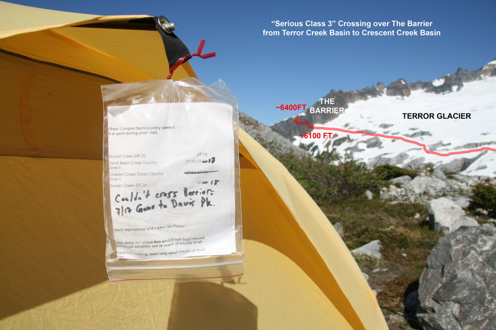
The west wall of Terror Basin is called the Barrier, and you'll need to cross it if your plan is to traverse into Crescent Creek Basin, where you can climb The Chopping Block, Mt. Terror, or other points to the west. The Barrier often lives up to its name, and has turned around many parties (Section 5 on this page—on traverse "cruxes" in the Pickets—describes crossing the Barrier).
 |
| | APPROACH 7: Goodell Creek to Crescent Creek Basin |
 |  |
| | |
If, on the other hand, you don't want the complexity of crossing the Barrier, or you've set your sights on climbs in Crescent Creek Basin (such as the Chopping Block, Himmelhorn, West Ridge of Terror), you can ascend from Goodell Creek to Crescent Creek Basin. This way is brushy and hot and less scenic but is quicker if you are heading for Mount Terror or other western summits of the Southern Range.
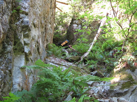
The approach begins as for Terror Creek basin, on the 4 mile old roadbed along Goodell Creek. When you get to the stone arrow/cairn, continue straight ahead on a faint trail. (Do not turn off to the right on the more defined trail, as this is the trail that takes you to Terror Creek Basin, as described above.) From the cairn, continue traversing through relatively open forest on faint trail. You are heading due north until you hit Terror Creek (you'll hear the roar of water). The faint path now contours above the creek for about a 1/2 mile. Eventually a massive log jam marks the point to cross Terror Creek (roughly 2100 feet elevation). Become hyper-attentive for signs of passage around here. There is plenty of brush on both sides of the creek. Fill up with water at the Creek.
You definitely want to find the trail heading up the ridge on the west side of Terror Creek. The first time I took this approach route, we did not search hard enough for the trail, figuring its existence was a myth; as a result we battled rock band after rock band. The next time, we found the trail (albeit faint) and had a much easier time. Once you have found it, somewhere near the logjam creek crossing, follow it faithfully up to the forested ridge crest at about 3800 feet. There is a minor saddle here, and in 2008 there was a balloon tied to a tree to mark this spot for climbers descending via this route (not there in 2009). Pat yourself on the back here because many folks have gotten lost on the ascent or descent of this trail and endured not only bushwhacking but difficulties with hidden cliffs in the forest.
You are now on the lower part of the Barrier. From here, follow the brushy ridge crest. The going is a bit easier, although the faint trail is not always easy to find. At timberline at 5,600 ft, you can traverse easily up slopes and snow in "Stump Hollow", an open slabby/heather basin between the Barrier ridge and the Chopping Block (marked as Pinnacle Peak on the USGS maps). There is good camping on the Chopping Block ridge.
From Crescent Creek Basin, common objectives include the Chopping Block, West Ridge of Terror, Himmelhorn, and other western Southern Pickets. It is possible to cross the Barrier into Terror Basin to the east (where you will need to go to access Inspiration and McMillan Spires, for instance). However, descending the Barrier to Terror Creek Glacier is tricky (see description in Section 5) and you cannot see this route from the western side. Unless you have crossed the Barrier from the east and are familiar with the route, it is best to access Terror Basin from the Terror Basin approach (described above).
 |
| Some Popular Traverse Options |
Once you have done the hard work of getting into the Pickets, it is time to enjoy some high alpine traversing and climbing. Any pairing of the approach routes discussed in the previous section is possible. For all but the Easy Ridge approach, the trailheads are only miles apart and a loop trip can be done with a short car plant or hitchhike.
Primary resources for climbs and traverses in the Pickets are the Cascade Alpine Guide Volume 3 and Tabor and Crowder's Routes and Rocks in the Mt. Challenger Quadrangle. There are countless options for an adventure in the Pickets, involving any permutation of approach route, summits en route, ridge traverses, exploration days, exit routes, etc. Almost any trip you can think of is doable, but whether it is enjoyable and safe depends on your personal enjoyment of masochism and your experience. Take a look at the maps in this section to get some ideas of ways you can link different route lines. Below I will mention some of the more popular and/or aesthetic cross-country traverse options in the Pickets. While most can be done in either direction, I have described them in the direction that in my opinion offers the best views and climbs and up-down terrain along the way.
The section after this details a couple of the main traverse cruxes in the Pickets.
| Traverses in the Northern Pickets |
 |
| showing various traverse options in the Northern Pickets |
| | For the backpacker who loves rugged terrain but doesn't want to do any climbing: |
Wiley Ridge - Luna Basin - Luna Col - Access Creek
5-6 days. Could substitute the Easy Ridge approach for Wiley Ridge, but this would entail a more distant car plant and crossing the Challenger Glacier.
5-6 days. Could substitute the Easy Ridge approach for Wiley Ridge, but this would entail a more distant car plant and crossing the Challenger Glacier.
| | For the Picketeer who wants to climb moderate summits: |
WHATCOM Peak (3rd) - CHALLENGER (cross glacier and climb, 5.6) - Luna Basin - Luna Col - LUNA (4th) - FURY (3rd) - Access Creek
6-7 days. 4 summits, but any can be bypassed. Involves crossing a major glacier. Approach Whatcom Peak via Little Beaver or Easy Ridge approach (Easy Ridge involves a distant car plant, Little Beaver involves expensive water taxi). Could also approach via Wiley Ridge.
6-7 days. 4 summits, but any can be bypassed. Involves crossing a major glacier. Approach Whatcom Peak via Little Beaver or Easy Ridge approach (Easy Ridge involves a distant car plant, Little Beaver involves expensive water taxi). Could also approach via Wiley Ridge.
| | For the Picketeer who wants to climb a classic North Buttress (and perhaps other climbs): |
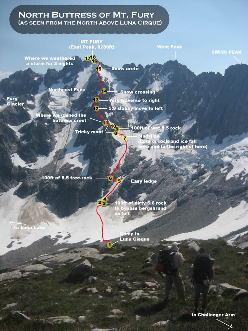
Wiley Ridge - Luna Basin - FURY North Buttress (5.8+) - Luna Col - Access Creek
6-7 days, could be much longer if more summits are added. The climb of Fury is very committing and should probably be done as a carry-over (you can camp on summit). Other summits include Whatcom (if Little Beaver or Easy Ridge approach), Challenger, Luna, Outrigger (on the north side of Fury), Fury W Peak (not often climbed), Swiss Peak (from Luna Basin), etc.
6-7 days, could be much longer if more summits are added. The climb of Fury is very committing and should probably be done as a carry-over (you can camp on summit). Other summits include Whatcom (if Little Beaver or Easy Ridge approach), Challenger, Luna, Outrigger (on the north side of Fury), Fury W Peak (not often climbed), Swiss Peak (from Luna Basin), etc.
| Traverses in the Southern Pickets |
 |
| showing various traverse options in the Southern Pickets |
| | For the backpacker who loves rugged terrain but doesn't want to do any climbing: |
Terror Basin - Stetattle Ridge
4-6 days. Can be done in either direction. Great views of the Southern Pickets. Augment with exploration side-trips from camps.
4-6 days. Can be done in either direction. Great views of the Southern Pickets. Augment with exploration side-trips from camps.
| | For the Picketeer who wants to climb relatively non-technical summits: |
Terror Basin - WEST MCMILLAN Spire (3rd) - Barrier Crossing high - The PYRAMID (3rd) - Crescent Creek Basin - TERROR West Ridge (mostly 3rd, some low 5th) - The Barrier
4-6 days. 3 summits, but any can be bypassed. It is also possible to just climb West McMillan and exit via the Terror Basin approach. Or just climb Mt. Terror and enter and exit via The Barrier. Entrance and exit trailheads are the same.
4-6 days. 3 summits, but any can be bypassed. It is also possible to just climb West McMillan and exit via the Terror Basin approach. Or just climb Mt. Terror and enter and exit via The Barrier. Entrance and exit trailheads are the same.
| | For the Picketeer who wants to climb some more classic and challenging routes: |
Terror Basin - INSPIRATION East Ridge (5.9) - Barrier Crossing low - CHOPPING BLOCK (5th) - Crescent Creek Basin - HIMMELGEISTERHORN Wild Hair Crack (5.7) - TERROR Stoddard Buttress (5.8+) - The Barrier
6-8 days. 4 summits, but any can be bypassed or more can be added, such as West McMillan, Degenhardt, and The Pyramid. Could climb Inspiration West Ridge (5.6) or South Face (5.8) as well or in place of the East Ridge. Could climb Terror's original North Buttress route instead of the Stoddard Buttress, either of which is very committing. The approach to the north side of Terror involves very rugged terrain passing through the Otto-Himmel Col and crossing the Mustard Glacier. Could break this trip into two, one just for Crescent Creek Basin climbs and one just for Terror Basin climbs. Entrance and exit trailheads are the same.
**In 2003, Wayne Wallace, Mark Bunker, and Colin Haley did a high traverse of all the major summits of the Southern Pickets, from Little Mac to Frenzelspitz. As far as I know, as of 2011, this rugged route has not been repeated.
| Traverses linking the Northern and Southern Pickets |
 |  |
| showing various traverse options linking the N and S Pickets | (for selected traverses) |
| | For the Picketeer who loves very rugged terrain but doesn't want to do any climbing: |
"East Side Traverse": Wiley Ridge - Luna Basin - Luna Col - Picket Pass - Otto-Himmel Col - The Barrier
or
"West Side Traverse": Easy Ridge - Perfect Pass - Pickell Pass - Picket Pass - McMillan Cirque - Stetattle Ridge
or....
7-10 days. Several route variations possible—entering via either Wiley or Easy Ridge, traversing either Luna Basin or the west side of northern Pickets; exiting via either Otto-Himmel Col / The Barrier or McMillan Cirque / Stetattle Ridge. Any route goes through Picket Pass. The first route listed above travels through areas described on this page. The second route listed above travels through more obscure terrain: the first half via Pickell Pass up to Picket Pass is described in the back of the Cascade Alpine Guide, while the second half via McMillan Cirque—which has the potential to be one of the great hellholes of the North Cascades—involves traveling under the towering northern walls of the Southern Pickets and is described in Tabor and Crowder's Routes and Rocks in the Mt. Challenger Quadrangle. The second route listed above also involves trailheads that are a much further drive apart than the first route listed above. Via any variation, this entire route covers very rugged terrain.
| | For the Picketeer who wants to climb as many summits as possible en route: |
"Technical Traverse": WHATCOM Peak (3rd) - Perfect Pass - CHALLENGER (cross glacier
and climb, 5.6) - Luna Basin - FURY North Buttress (5.8+) - OUTRIGGER
(4th) - Picket Pass - TERROR Stoddard Buttress (5.8+) - Crescent Creek Basin - CHOPPING BLOCK (5th) - The Barrier
7-10 days. 6 summits, but any can be bypassed. Could bypass Fury's North Buttress by going to Luna Col (from where you can add another summit by climbing Luna) and around the backside of Fury. Could bypass Terror's north side by passing through the Otto-Himmel Col (from where you could climb Wild Hair Crack on Himmelgeisterhorn to make up for your lost summit, or even decide to climb the W Ridge of Terror). Involves crossing a major glacier, and the terrain and climbs on this route are very rugged and committing. Approach Whatcom Peak via Little Beaver or Easy Ridge approach (Easy Ridge involves a distant car plant, Little Beaver involves expensive water taxi).
| Traverse "Cruxes" and Common Questions |
Also, I often get emails relating to route-planning in the Pickets. I've included some of the more popular questions and my responses at the end of this section.
| | Crossing the Barrier as a link between Terror Basin and Crescent Creek Basin |
That said, it is possible to cross the Barrier. There are 2 ways: (1) a lower crossing on a loose ledge system at the lower end of the Terror Glacier or (2) a higher crossing over moats and steep choss at the upper end of the Terror Glacier just below Degenhardt. Either way takes less than an hour. Both ways are equally harrowing, classic "Pickets Class 3." Wet conditions (such as from recent rains) could make it downright death-defying. And either way, melt patterns will influence how tricky it is to get off the snow and onto the rock. The photos below show the two Barrier crossing options.
The lower crossing takes you from Terror Basin into Stump Hollow, from which you can traverse easily to the Chopping Block and Crescent Creek Basin. This is the crossing to use if you plan on camping on the Chopping Block ridge or climbing Chopping Block. The upper crossing bypasses the Chopping Block ridge and takes you from Terror Basin into Crescent Creek Basin. This is the crossing to use is you plan on camping at the camp below Terror and climbing one of the Southern Pickets (Degenhardt, Pyramid, Terror perhaps) from here.
It is possible to cross The Barrier from either direction at the high or low crossing, although having done the crossing myself, I would recommend crossing from east to west (Terror Basin to Crescent Creek Basin) as this way you can see the cliff you must surmount rather than trying to find it blindly from above.
 |  |  |  |
| | Crossing Picket Pass as a link between the Northern and Southern Pickets |
From the north, parties typically approach Picket Pass after a climb of Mt. Fury. This route is described in the Cascade Alpine Guide, and involves descending the SE glacier on Fury and climbing over Outrigger Peak to gain the ridge. By various reports, traversing over Outrigger can be anything from 3rd class to low 5th; the 3rd class can probably be achieved by traversing around the west side and not heading to the summit too early (as my party did in 2008). From Outrigger Peak, it is mostly easy ridgetop hiking to get to Picket Pass. There is one 50-ft section that most parties rappel if coming at it from the north, although I have heard at least one report of 4th class ledges on the east side that can avoid the need for a rappel and also make this section surmountable if coming from the south. There is superb camping at Picket Pass with stunning views of the sheer north walls of the Southern Pickets.
(Update of an alternative route that was pointed out to me after I posted this page: "Missed a major exit from E. Fury to Picket pass. No need to go over Outrigger Peak. Go off E. Fury on its west. A small bit of class 3 maybe. More like sandy class 2 on slab. Missed the main route from Luna Col to E. Fury as well that most parties take. The ridge crest. 1 move of class 5.0 3rd class with awesome views in all directions and NO glacier travel going up E. Fury. One can traverse the entire picket range without touching a glacier if one wishes. Just as the original party did. Look up Tabor and Crowder's Routes and Rocks." (Note: I have not done this route variation, so you might want to check the noted Tabor/Crowder resource to confirm it.))
To continue the southwards traverse from Picket Pass, there are a couple of options. Some climbers have dropped onto Mustard Glacier from Picket Pass, but this proved to be a tricky and tedious descent. In 2008, on a complete traverse of the Pickets, my party stayed on the ridge as it heads southwards towards the Ottohorn-Himmelhorn Col. This requires a few pitches of low-fifth climbing to a spectacular campsite (I debated whether or not I should reveal this little gem, but finally decided that anyone who gets this far deserves to know about it!). From here, continue to scramble up the ridge until sheer granite walls impede further travel. At this point, a short Class 3 descent brings you directly onto the Mustard Glacier. You can now traverse around to the North Ridge of Terror, or continue straight ahead up to the Ottohorn-Himmelhorn Col and into Crescent Creek Basin. Reaching the col from the north is straightforward if snowfilled, but later in the season, it will take some loose and tricky 5th class to reach the notch. The south side of the col is a bit more friendly, and once in Crescent Creek Basin, the technical part of the traverse is over.
 |  |
| Some questions I've been emailed relating to route-planning in the Pickets |
A. I’ve done this, and it’s a good way to do it. However, it is admittedly going to be tricky to descend the Chopping Block approach without ever having come up it. The first time I descended this way no one in my party had used this approach before, and we did deal with several hours of cliff bands and steep bushwhacking to finally get ourselves out. But that’s part of the Pickets experience. The second time I descended this way we were more familiar with the terrain and we had an easy time out. Another cruxy aspect to this is the Barrier crossing, which was described above.
Q2. Or, since the Terror Basin approach is well-defined, would it be better to take the Chopping Block approach in and start with Terror then finish with McMillan and head out via Terror Basin?
A. The Terror Basin approach is certainly more defined than the Chopping Block approach, and would lead to an easier exit for sure. However, it’s the Barrier crossing that would be the problem. Going at it from the Chopping Block side, you are approaching it blind and unless you’ve done it already from the other side, you will likley get into a lot of trouble. The Barrier really should be crossed from the Terror side, especially for first timers.
Q3. What's the best way to the base of the north buttress of Terror from Picket Pass?
A. I’ve heard stories of parties trying to descend directly from the pass and encountering a lot of sketchy cliffs. My party found a good route was to stay on the ridge and head from Picket Pass towards the Otto-Himmel col (see photo just above). There's a couple of hundred feet of 4th to low 5th to go up (we got out a rope because we had one), and then near the top of the ridge we found a 3rd class ramp that dropped right onto the Mustard Glacier. If the glacier is not opened up, it would be a simple descent and then traverse to the base of the north side of Terror. However, any approach across the Mustard Glacier is better to do before the glacier really starts to open up in the late summer.
Q4. Is getting into Luna Cirque from Challenger Arm difficult?
A. Getting into Luna Cirque is just a tedious sidehilling traverse and descent, if you manage to avoid the cliff bands. I’ve gone into the cirque three times, two of these times it was fine and once it was harrowing getting-out-ropes-and-chucking-packs cliffs. I think the secret is to not head down to early. Stay high until you can see a snow or talus slope to pick your way down, and don’t get suckered into the cliffs thinking you can find your way down the slabs.
Q5. I noticed you did the complete Pickets traverse from north to south. Can it be done from south to north?
A. Sure, although this direction will make it so you cannot incorporate climbing the classic north sides of Terror or Fury into the traverse. Instead, you traverse through Otto-Himmel Col, to Picket Pass, across the south side of Fury (add a couple of hours to tag the summit while you are there), to Luna Col, across Luna Cirque to Challenger Arm (add a couple of hours to tag the summit while you are there) and then out via Wiley Ridge or a Perfect Pass approach. However, you'll end the trip with a sore neck, from the constant looking over your shoulder to see the Pickets towering behind you.
Q6. Are glaciers a problem in the later summer? Are there some areas that should be avoided in the later summer?
A. The glaciers usually start to open up in August, making for some large crevasses and moats that will make some parts of the route difficult or unsafe. Areas that are particularly problematic as the snow melts are: Challenger Glacier crossing and the bergschrund near the summit; snow approach at the base of the North Buttress of Fury route; Mustard Glacier approach to the North Buttress of Terror; north side of the Otto-Himmel Col (very loose rock and moats necessitating steep rock climbing), moats on the Terror Glacier. In general, in the Picket Range, traversing and accessing routes is easier in the early summer when there is more snowcover.
 It's easy to get off route on the exit from Crescent Creek Basin via the lower Barrier. Then you're in for a classic Pickets adventure of cliff bands and steep 'schwacking.... |  The traverse down into Luna Cirque. The trick is to stay high until you get past the cliff bands and then you can easily descend on a snowfield. | 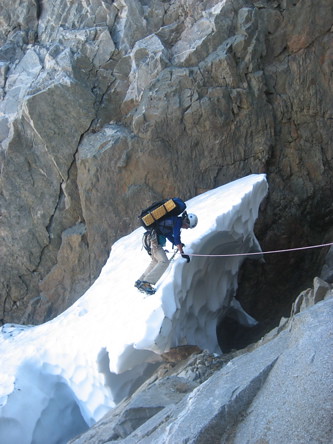 Moats can be problematic in the later season; this moat is on the north side of the Otto-Himmel col. | 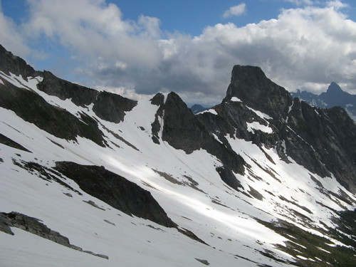  Early season snowcover can make traversing easier. Photos of Crescent Creek basin in late June and early August 2009. |
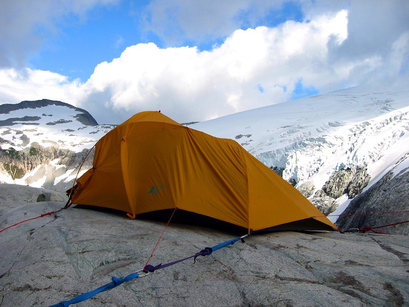
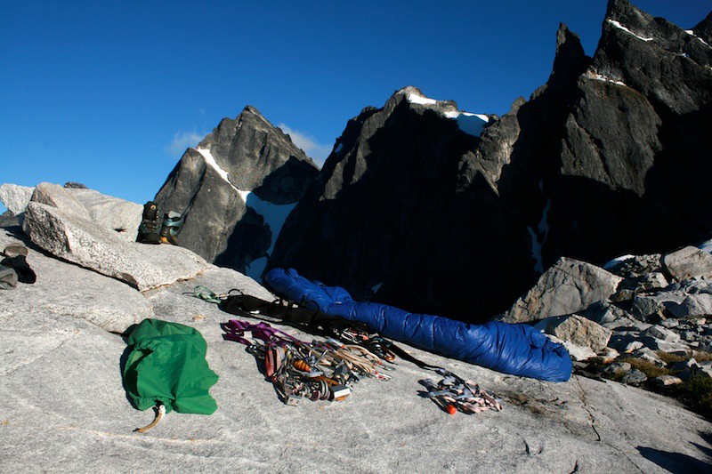
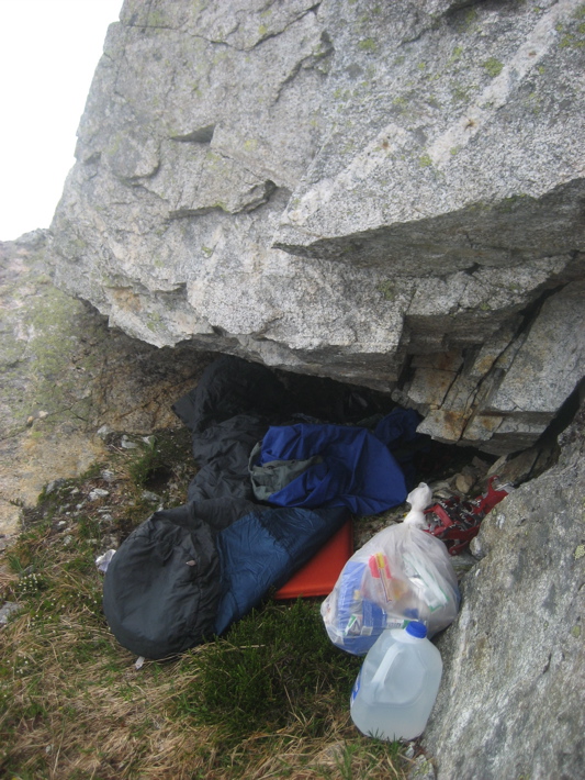
| Camping |
A permit from the North Cascades National Park Visitor Center in Marblemount (360-873-4500) is required for any overnight stay in the park, almost mandatory for a visit to the range. (A few have climbed The Chopping Block or West McMillan Spire in a day, but almost any Pickets adventure involves at least one night.)
There is also a lone wooden shelter at Beaver Pass. You are only supposed to use it in case of emergency, though I've seen that rule ignored more often than not. Say Hi to Frank the resident deer mouse before plunging up towards Wiley Ridge.
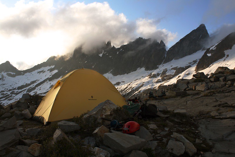
| | Some Campsites in the Northern Pickets |
| | |  |  |
| Meadows, water, and views of the towering Luna Peak. | Gentle, great views of Challenger. | Water, Challenger, and sunset views at this truly perfect pass. | A unique spot on the granite slabs on the south side of Whatcom Peak. |
 |  |  |  |
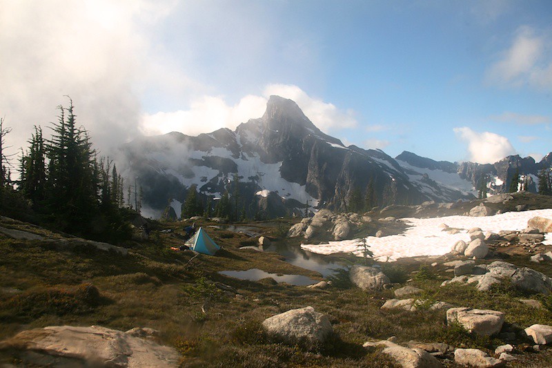
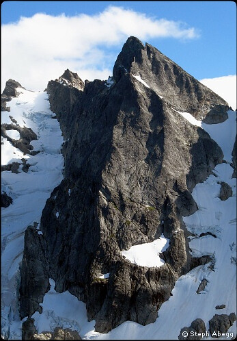
| My parents camping near Challenger Arm in 1981, Mt. Fury towering in background. | Flat sandy spot great for tossing a frisbee or basecamp before climbing north buttress of Mt. Fury. | Just below the SW Ridge of Luna Peak, with spectacular views of Fury and Luna Cirque. | An amazing location in the heart of the Pickets—360° views for sure. |
 |  | ||
| The only man-made construction you will find on a Pickets trip. | Sleeping on the trail waiting for a partner who had gotten benighted while undergoing horrendous bushwhacking. |
| | Some Campsites in the Southern Pickets |
 |  |  |  |
| Nalgene meteor shower at camp, looking south towards Chopping Block. | Looking north towards Crescent Creek Basin and Mt. Terror. | A flat and well-watered basecamp for climbing Inspiration and W McMillan. | This camp is perched on a knoll, Chopping Block in background. |
 |  | ||
| North side of Southern Pickets, just above Picket Pass. | Stranded for five days in a cave after a climbing accident an ensuing bad weather. |
| Weather |
The Pickets are much more fun in good weather. With their ruggedness and route-finding challenges, poor visibility or uncomfortable dampness can make it a harrowing adventure. Because of the notorious unpredictability of Pacific Northwest weather, it is best to plan a rather flexible weather window for scheduling a foray into the Pickets.
 |  |
| Steph's Adventures in the Pickets |
 |
| |
I've been in the Pickets at least eight times. My obsession with the range began in 2002, when my dad and I (then 19 years old) backpacked into Luna Basin (Northern Pickets). Denied of the summit of Challenger by poor weather, I vowed to come back. Since then, I've tracked all over the range, doing all approach routes but one and spending numerous memorable nights in some of the most rugged and beautiful terrain on Earth. Links to my trip reports for the Pickets are given below.
| LINK | ROUTE | DATE | RANGE | APPROACH ROUTES (w/ # from above) | COMMENTS |
(no TR) | 1. Hannegan Pass to Whatcom Pass, across Whatcom Glacier and Challenger Glacier to Luna Basin. | August 4-10, 2002 | NORTHERN | IN: Whatcom Glacier (#2) OUT: Whatcom Glacier (#2) | My first Pickets adventure, with my dad. We didn't have the best weather so we did not get to climb Challenger as we had planned. |
 LINK | 2. Perfect Pass via Easy Ridge, climb of Whatcom Peak. | July 22-26, 2005 | NORTHERN | IN: Easy Ridge (#1) OUT: Easy Ridge (#1) | A fun trip with my mom. We basked in the sun at Perfect Pass, I climbed Whatcom Peak, and vowed to come back and get further into the Picket Range. |
 LINK | 3. Big Beaver to Wiley Ridge to Mt. Challenger, exited via the fated Luna Creek adventure. | July 22-26, 2007 | NORTHERN | IN: Wiley Ridge (#3) OUT: Luna Creek (not recommended) | Epic Pickets bushwhacking adventure! |
 LINK | 4. Found a a new approach route into the Pickets, climbed Luna Peak, exited Access Creek. | Aug 21-24, 2007 | NORTHERN | IN: Wrong Access Cr. (not recommended) OUT: Correct Access Cr. (#4) | Didn't quite go as planned, but I got my favorite all-time panorama from the summit of Luna. |
 LINK | 5. Entered via Terror Basin, climbed Inspiration (E Ridge), crossed the Barrier, climbed Chopping Block (NW Route) and Mt. Terror (W Ridge), exited via the Barrier. | July 15-19, 2008 | SOUTHERN | IN: Terror Basin (#6) OUT: Barrier (#7) | A highly successful trip into the Southern Pickets, as a reconnaissance of the exit route for a planned complete Pickets traverse later that summer. |
 LINK | 6. Complete N to S Pickets Traverse, climbed north sides of Whatcom, Challenger, Fury, and Outrigger. | Aug 5-12, 2008 | NORTHERN and SOUTHERN | IN: Whatcom Pk. N Ridge (#2) OUT: Barrier (#7) | An amazing eight day traverse through the entire Picket range, with stellar campsites, climbs, and a memorable three nights stranded in a snowstorm in a floorless tent on the summit of Mt. Fury. |
 LINK | 7. First ascent of Thread of Ice on Twin Needles. | June 26-28, 2009 | SOUTHERN | IN: Barrier (#7) OUT: Barrier (#7) | This first ascent was a great line of snow and ice up the north side of Twin Needles. We hit it in perfect condition. |
 LINK | 8. Entered via Terror Basin, climbed Inspiration (S Face) and West McMillan Spire (W Ridge), crossed the Barrier, climbed Degenhardt and The Pyramid and Mt. Terror (Stoddard Buttress), exited via the Barrier. | July 2-9, 2009 | SOUTHERN | IN: Terror Basin (#6) OUT: Barrier (#7) (and Helicopter) | This wildly successful trip came to a crashing halt when my partner fell on the north side of Mt. Terror, breaking his femur and sustaining head injuries. A rescue ensued, involving a lucky cell phone call, a harrowing helicopter rescue, and one climber stranded for five days in a cave on the north face of Mt. Terror. |
 LINK | 9. Approached Pickell Pass via a Mystery Ridge to Pioneer Ridge traverse, climbed Swiss Peak (S Route) from Pickell Pass, traversed below towering spires to Perfect Pass and climbed Challenger Middle Peak (W Flank) and Whatcom Peak (S Route), exited via Easy Ridge. | Aug 9-15, 2012 | NORTHERN | IN: Mystery Ridge-Pioneer Ridge (non-standard route) OUT: Easy Ridge (#1) | On this trip the Northern Pickets were a 2-day, 3-peak section of a much longer enchainment of ridges and passes that took us through some of the most wild and remote parts of NCNP. |
| "Picketed" |
...two climbers were bushwhacking out of the Pickets and got separated in the green hell of the descent. The first climber stumbled out onto the Big Beaver trail and waited half of a day for his buddy. At long last he was spotted, stumbling packless out of the brush. "Hey, where the F^&% is your pack?" "F&^* that stuff (tent, rope, ice ax, crampons...)," he replied. "I ditched it!"
Based on a true story. I can vouch for it.
Based on a true story. I can vouch for it.
| Aerial Photos (and Video) |
I've had the amazing opportunity to fly over the Pickets on several occasions, with pilot and aerial photographer John Scurlock. To see some of these aerial photographs of the Pickets (as well as other summits in the North Cascades) go to my aerial photography page.
•
And finally, here is a 4-min video clip of flying over the magical wintery Picket Range in February 2013. (Soundtrack: Our Shangri-La, Mark Knopfler & Emmylou Harris, All The Road Running, live version.)
• Other External Links
* Mount Challenger - good description of the climb and approach from Wiley Ridge by Sergio Verdina.* Ski Descent of Mount Fury North Face - Yes, this really happened.
* "Three Amigos" Traverse - one of the author's own Picket Range extravaganza with Theron W. and Aidan H.
* Wayne Wallace's site - Wayne Wallace's accomplishments in the Picket Range are really something to marvel at. I don't know anyone who has more experience than him. Read about his trips here.
Some links to mountaineering or hiking traverses well described on NWHikers.net:
* Tom Sjolseth and Fay Pullen have a great traverse TR here.
* A super Picket Range traverse TR from Matt Burton.
• Just for Fun
In 2005, Michael Stanton made a movie which gives a pretty good overview of the Pickets. It's a computer-generated flight over terrain data, first circling around the Northern Pickets cirque, then down into McMillan Cirque (where no one ever goes). Might be fun to see, though nowadays Google Earth makes it so easy!Also, here are a couple of interesting photo comparisons...
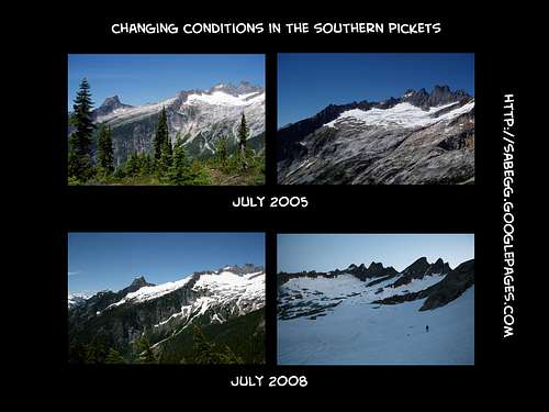 Interesting comparison of conditions in the Southern Pickets during a low snow year (2005) and a low snow year (2008) | 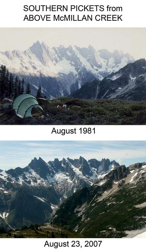 Southern Pickets in 1981 (my parents) and 2007 (me). The glaciers are shrinking... | 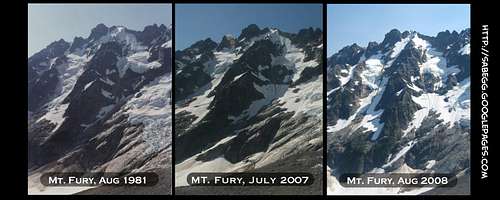 The north buttress of Fury in 1981, 2007, 2008. The glaciers are melting.... |
seano - Nov 11, 2014 12:04 am - Hasn't voted
"craziness"> "Crazy" people have climbed The Chopping Block or West McMillan Spire in a day, but almost any Pickets adventure involves at least one night. This is not true. As of 2014, a well-beaten climbers' trail from Goodell Creek means that southern Pickets peaks are reasonable day-trips for someone with decent fitness, equivalent to moderately-hard stuff in the Sierra.
mvs - Nov 19, 2014 4:16 pm - Hasn't voted
Re:Good grief, a minor trace of hyperbole and humor was identified, and must be eliminated. :-|
seano - Nov 19, 2014 10:48 pm - Hasn't voted
Re:Sorry if it came across like that, but people are easily intimidated when they shouldn't be. Heck, I was the victim of some Pickets mystique before I visited. They may have been an ordeal when Beckey wrote his guidebook, but things have changed, and saying otherwise is a corrosive kind of "anti-sandbagging" that discourages people from enjoying something within their abilities. They're still a fair amount of distance, and a lot of elevation, but if you go up Goodell Creek, that distance and elevation translate into time the same way they do anywhere else.
mvs - Nov 20, 2014 12:41 pm - Hasn't voted
Re:Yeah, I see your point, and obviously I agree in that we wouldn't have even created this page if we wanted to discourage people from going there. I don't think the phrasing was "corrosive," rather it was meant to be inspirational and maybe a little funny. Still, a kinder editor changed the wording to be unoffensive which is doubtless for the best. Happy climbing.
paulrc - Sep 11, 2016 6:02 pm - Hasn't voted
ThanksHave to say thanks for putting this together. One of the best SP pages I've come across.