
-
 63500 Hits
-
 88.6% Score
-
 27 Votes
|
|
Area/Range |
|---|---|
|
|
48.71500°N / 121.995°W |
|
|
Mountaineering |
|
|
Spring, Summer, Fall, Winter |
|
|
Introduction

The Twin Sisters Range is an interesting sub-range outlier of the Cascade Range. The entire range is composed of rock which is actually a fragment of subcontinental mantle which has thrust up through the crust. Located just 21.5 miles (34.6km) from Bellingham Bay, the range sharply contrasts the rock and mountains that surround it. From a distance the rock may appear as any number of hues depending on the time of day and lighting but from close by it appears as a bright reddish orange. The Native Americans called the range "Kwik-Kwek Smanik" which is believed to mean "red rock" or "red mountains". The color is related to the iron content.

The range is of particular interest to climbers. The rock (olivine) is extremely grippy and makes for some of the best scrambling in Washington State. Given their proximity to Mt. Baker and Bellingham Bay the views from the range are spectacular. The Olympic Range, the Coast Range in B.C., the Picket Range, The Cheam Range B.C., and the North Cascades all provide eye candy for climbers.
South Twin Sister (the tallest of the range) saw its first ascent on August 1, 1891 by J.M Edson, E.A Hegg, and P.J Parris.
From North to South:
-North Twin Sister 6,640ft (2024m)
-South Twin Sister 7,000ft (2134m)
-Skookum Peak 6,616ft (2,017m)
-Hayden Peak 6,480ft (1,975m)
-Little Sister 6,600ft (2,012m)
-Cinderella Peak 6,480ft (1,975m)
-Shirley Peak 5,800ft (1,768m)
-Trisolace Peak 5,907ft (1,801m)
-Barbara Peak 6,000ft (1,825m)
-Nancy Peak 5,960ft (1,817m)
-Last Sister Peak 5,562ft (1,695m)
-Step Sister Peak 5,120ft (1,561m)
Likely the first winter traverse
Getting There
Most climbing routes are approached via Dailey Prairie. Because of the long distance covered on logging roads it is recommended that you take a bicycle so that on the way out you can roll down to your car. Also many stretches of the logging roads can be ridden uphill. There are several different ways to access Dailey Prairie but the best is without a doubt the Middle Fork Road that has access to a bridge which crosses the Middle Fork Nooksack River. This access has considerable less distance and less elevation gain than the other options.
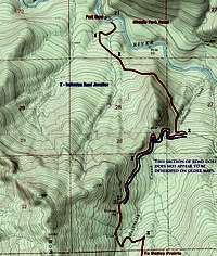 Map 1 |
 Map 2 |
North Access, Middle Fork Road:
- Take Exit 255 off of I-5 (Sunset Drive-Baker Hwy)
- Head East on Hwy 542 for 16.7 miles until you pass milepost 16
- Turn Right on Mosquito Lake Rd
- Follow Mosquito Lake Road for 4.8 miles until just South of Porter Creek
- Turn Left on Road 38 (Middle Fork Road)
- Follow Middle Fork Road for another 4.8 miles turning right at a junction that leads down to the gated bridge
- Call the Olivine Corp. (360) 733-3332 to see if the gate is open. This is unlikely.
West Access, Blue Mountain Road via Mosquito Lake (limited access due to frequent road work. Call ahead)
- From Acme on Highway 9 take Mosquito Lake Road 4 miles
- Take Road 4000
- call the Campbell Group at (360) 336-9733
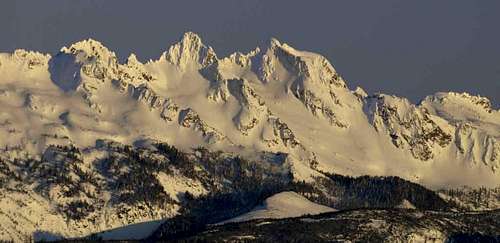 Barbara Peak And Nancy Peak
South Access, Highway 20:
- At Ensley Road (overpass bridge) in Hamilton Turn North
- In 0.5 miles reach the Crown Pacific Company entrance gate
- Crown Pacific (360) 826-3951
- For more information call (206) 339-5548
No parking passes are required to park at the gate. If the gate is open, enter at your own risk, it may not be open when you leave. Certainly do not block the road anywhere you park or expect to be towed and heavily fined. Relations between climbers, the logging companies that own the roads, and Olivine Corporation who owns the land have traditionally been turbulent, Please do not give them reason to restrict all access to climbers. Keys are no longer given out for the North access (Dailey Prarie) due to concerns of illegal garbage dumping and traffic during mining and logging operations.
The South gate (accessed from Hwy 20) is manned, and they may grant access if you are polite and courteous.
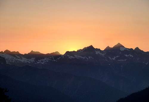 Photo Courtesy Of Beau Ramsey
Geology
The Twin Sister Range is the largest body of exposed Olivine (Magnesium Iron Silicate) in the Western Hemisphere. A fragment of the Subcontinental Mantle brought up by the Shuksan Thrust, the range was emplaced by faulting into sedimentary rocks of the Chuckanut Formation as a solid mass. Olivine is the grippiest rock I have ever climbed on.
The few significant glaciers are retreating at a rapid rate and will probably be gone within a decade. The largest glacier is the Sisters Glacier about 1km accross. Two smaller glaciers, called the Green Glaciers, flow into Green Creek.
Mining and Logging
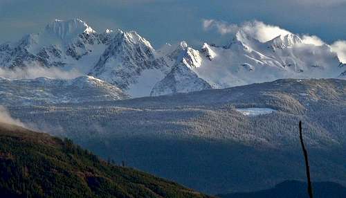 South Twin, Hayden Peak, Little Sister, and Cinderella Peak
This area is heavily logged and has been periodically mined as well. Olivine is extracted and used for gemstones and sandpaper/blasting products. As such one can understand why the rock is so grippy. During the week please be respectful to the logging operations as they have purchased rights to the land.