
-
 6055 Hits
-
 79.04% Score
-
 10 Votes
|
|
Route |
|---|---|
|
|
46.66025°N / 12.66054°E |
|
|
Hiking |
|
|
Summer, Fall |
|
|
Most of a day |
|
|
Medium hard hike |
|
|
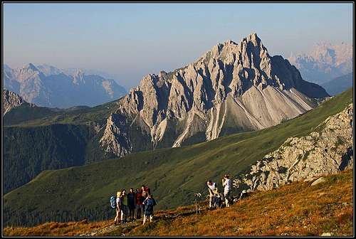
General Overview
On Karnischer Hoehenweg / Traversata Carnica

Eastern view

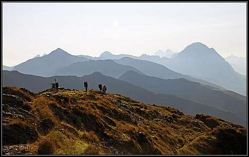
Northern view

On the trek
The main crest of Carnic Alps is ideal for a long-distance trek. Karnischer Hoehenweg / Traversata Carnica goes along all its 140 kilometers, from Sillian or Sexten on the west to Thoerl/Maglern on the east. Often the route goes separately on the northern, Austrian side of the ridge (Karnischer Hoehenweg) and on the southern, Italian side (Traversata Carnica). In the western half, its daily stages could be the following ones:
1. Innichen or Sexten or Sillian - road or cablecar to the trailhead - Sillianer Huette - Obstanser See Huette. 6 h 30 min.
2. Obstanser See Huette - Porze Huette. 7 h.
3. Porze Huette - Hochweißstein Haus or Rifugio Calvi. 8 h 30 min.
4. Hochweißstein Haus or Rifugio Calvi - Eduard-Pichl Huette - Ploecken Pass / Passo di Monte Croce Carnico. 10 h.
General About Etappe 3
On Carnic Alps main ridge
As described on the pages of: Baerenbadegg / Croda Negra, Reiterkarspitz / Monte Cecido and Hochspitz / Monte Vancomun, in this section the Karnischer Hoehenweg goes mostly on the northern side of the ridge and Traversata Carnica mostly on the southern side. But by the ridge itself a marked path No. 172 goes. It is mostly broad, comfortable and panoramic, so it is also formally treated as the Carnic trek route here and is being used by most of hikers. That's the route which will be described here - in the west-east direction. For the reference, see also the three map sketches and the respective mountain pages!
The part of the ridge between Tilliacher Joch / Forcella Dignas and Luggauer Sattel / Sella di Luggau is made of older, paleozoic rocks. Those summits are not so sharp, mostly they are grassy to their tops and pretty rounded. East of Luggauer Sattel / Sella di Luggau the mountains are made of limestone or combined, but the route there avoids the highest summits.
Rating The Route (By Hiking Standards)
The grading system for hiking and scrambling routes is here.
0. General: many ups and downs with some 1200 meters of altitude overall. The path goes manily by the main ridge (W-E direction) or by the southern slopes. But there are also passages over the W, N and E slopes (important for winter ascents, when under snow). Gear: good hiking shoes and poles. If you intend to do a multy day trek, you might have with you also a tent, sleeping bag and some more food. In summer you can get food and beverages in huts too. For this section it is important to have enough water with you. For the whole 8-9 hours on the main ridge you will not get fresh water!
1. Effort: cca 1200m, many ups and downs, 8-9 hours.
2. Power: 1 - No difficulties, only walk-up.
3. Psyche: 2 - Easy (a few exposed, but secures passages).
4. Orientation: 1 - no difficulties, well marked.
Getting There

In Frohn Tal
To get to the start of the whole Carnic trek, you must of course reach Innichen or Sexten or Sillian. See the main Carnic Alps page how to get there.
But for stage 3, you can take the two approaches:
1. From Obertilliach in Lesachtal. In the town deter south and drive by the valley till the altitude of 1690 m, where you park at Klapfsee. The road further on to Porze Huette (45 min) is closed for public trafic.
2. From Val Visdende. By the valleys of Piave river and Cordevole creek drive into Val Visdende and where on 1261 m the road branches, drive left, past Locanda Alpina into Val di Londo. The road is closed on 1436 m, at Bivio Ciadon.
See also the page of Baerenbadegg / Croda Negra!
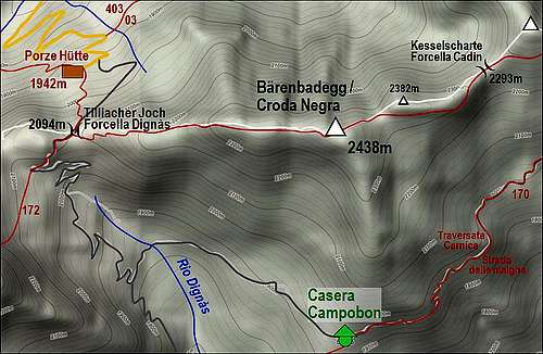
From Porze Huette, 1942 m, you have to Tilliacher Joch / Forcella Dignas only some 20 minutes. From the southern trailhead you have some 2 hours.
Route Description
Part 1: Baerenbadegg / Croda Negra
Part 2: reiterkarspitz / Monte Cecido
Part 3: Hochspitz / Monte Vancomun
Porze Huette - Baerenbadegg / Croda Negra

From Porze Huette go by the marked path southwards, directly up the slopes. Later this path reaches on the narrow mountain road (used also by mountain bikers) which soon brings you to the saddle, 2094 m. A very nice view towards the south and on the eastern face of Porze / Cima Palombino opens.

From Tilliacher Joch / Forcella Dignas you continue eastwards. The path first goes by the southern (Italian) side of the ridge, then you ascend on the ridge itself and can enjoy a broader and broader view. Still the closer you are to the summit of Baerenbadegg / Croda Negra the more the path avoids the ridge again and goes by the southern side. You can see many remains of the World War I, mostly recognizable are trenches and a few bunkers, then you are soon on top, 2438 m high. 1 hour till here.
Baerenbadegg / Croda Negra - Reiterkarspitz / Monte Cecido

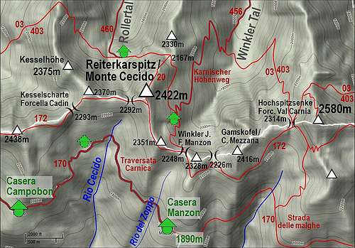
The descent by the E ridge of Baerenbadegg / Croda Negra is very gentle. From the saddle 2337 m we continue and detour by the S side point 2382 m, and then soon reach Kesselscharte / Forcella Cadin, 2293m. In the continuation the path goes again by the S slopes, detouring the summit of Stollen / Cold del Rocco, 2370 m. It's up to you whether you will take that summit too, from it the path continues more towards the N on Kesselhoehe, 2375 m, and further on Spitzkoefele, 2314 m. But if we continue eastwards, the path brings us almost horizontally on Forcella Cecido, 2292 m. Now the good 100 meters of the Reiterkarspitz / Monte Cecido, 2422 m, summit ridge are in front of us. The path goes again by the southern side. When it almost passes the summit, we deter left and ascend over the fore-summit bump on top. There's a nice cross and it's time for a short, panoramic rest. 30 minutes from Baerenbadegg / Croda Negra.
Reiterkarspitz / Monte Cecido - Hochspitz / Monte Vancomun

From Reiterkarspitz / Monte Cecido the main ridge goes on in almost southern, then south-eastern and finally in eastern direction. We first detour the bump of Cima Salvades, 2351 m, by the southern side and reach Winkler Joch / Forcella Manzon, 2248 m. There the path No. 25 comes from the left, Austrian side. We continue by the southern slopes of Cima Manzon, 2328 m, detouring it. All these summits are easy to be reached, but we don't need to pick up just every one of them. On the next saddle, Moser Scharte / Forcella Val Mezzana, 2226 m, the path does not ascend. It crosses by the S slopes further towards the E, now detouring the more rocky summit of Gamskofel / Cima Mezzana, 2416 m. This one sends a short, grassy side ridge towards the S and our path gently ascends on it.

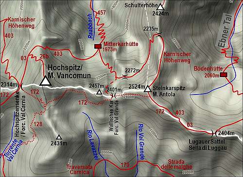
From the ridge the view on the upper part of Val Carnia and on the summit of Hochspitz / Monte Vancomun opens. The path descends a bit, but soon starts going horizontally again, keeping the altitude. We already examine the W slopes of our highest summit today, while the path brings us gently up on the saddle of Hochspitzsenke / Forcella Val Carnia, 2314m. From the N also the Austrian Karnischer Hoehenweg comes up there. Now the path must overcome the rocky W face of Hochspitz / Monte Vancomun. It crosses up first gently the slopes towards the SE, then turns directly up. Where overcoming the rock sections the path is secured by steel cables. In this section it requires some care, but for an average hiker it is not too hard. In turns we gain altitude and exit the face on the S ridge of Hochspitz / Monte Vancomun. From there, the main path No. 172 continues over the grassy slopes towards the east. Buth the summit above us is worth of ascent. A less beaten path deters from the main path left, keeping in the vicinity of the S ridge. We approach the summit from the W side, first we ascend the NW fore-summit with a cross on it, soon after it also the main SE summit, 2580 m. 2 hours from Reiterkarspitz / Monte Cecido.
Hochspitz / Monte Vancomun - Lugauer Sattel / Sella di Luggau

From Hochspitz / Monte Vancomun no marked path goes directly down towards the S. There are animal trails and the grassy slopes are not too steep anyway, so we best go directly down until we hit the path No. 172. By it we continue eastwards. The path soon reaches Forcella Vancomun, 2392 m. The next summit, point 2457 m, is rocky and looks harder accessible, so the path avoids it again by the southern side. It goes down, what we expected, but then over the steep, rocky southern slopes up again. These 50 meters of altitude loss is unpleasant, but we can enjoy the nature and views. The rocks of the main ridge here are very dark, looking almost as being of vulcanic origin. Finally the path, which is nowhere hard or too exposed starts crossing the grassy slopes more gently again and we reach Wallisches Kar / Forcella Val Grande, 2401 m. Again a path from the north comes there. We are very close to our next summit - Steinkarspitz / Monte Antola, 2524 m. The path goes by its S slopes, approaching the summit on only some 20 meters. In 5 minutes off the path you are by its cross. From Steinkarspitz / Monte Antola the main ridge continues in the SE direction. But if you would expect that you will only gently descend on Lugauer Sattel / Sella di Luggau, you are wrong. The ridge is still steep and rocky and the path goes carefully over a few narrow and also exposed passages. In some places it is also protected. Then only the ridge lets us out and we are on the very important saddle, 2404 m. 1 hour 30 min from Hochspitz / Monte Vancomun.
Lugauer Sattel / Sella di Luggau - Hochweißstein Haus
From Lugauer Sattel / Sella di Luggau the southern passages go far around the next mountain group. Traversata Carnica avoids here the main ridge, ascending finally Hochalpljoch / Passo dell' Oregone and one possible end of stage by Rifugio Calvi, 2164 m. But we shall continue by the Austrian side.
We descend from Lugauer Sattel / Sella di Luggau towards the NE, on the Austrian side, by crossing broad scree slopes below Weisse Lungern / Longerini Bianchi, 2468m, and Torkarspitze / Monte Pietra Bianca, 2573m. The path is now numbered 403. Later it gets more directly down and in less than 20 minutes we reach the green Luggauer Toerl (saddle), 2226 m, NE of which the sharp Weidenkopf, 2481 m, and Zwoelferspitz, 2598 m, are rising. From the saddle we descend further towards the east. On the altitude of some 2130 m the path branches. The right branch, where Karnischer Hoehenweg (No. 03 and No. 403) goes, traverses the slopes above the end of Frohn Tal (valley), finally reaching Hochweißstein Haus, 1868 m. 1 h 30 min from Lugauer Sattel / Sella di Luggau. The left branch however goes directly down in Frohn Tal. In less than 1 hour we are by Ingrid Huette, 1650 m, and a bit after it on the parking place where the road is closed for public traffic. 1 h 30 min from the saddle.
Mountain Huts

Ingridhuette
- Porze Huette, 1942m. Reachable in 45 minutes from the parking place in Obertilliacher Tal. 60 beds, opened from mid June till end September. Telefon (hut): +43/664/4038929. Telefon (valley):+43/4847/5243. Mobile: +43/664/4038929. E-mail: sport.auer@aon.at.
- Hochweißstein Haus, 1868m. Reachable in 45 minutes from the parking place in Frohn Tal. 16+40 beds, opened from mid June till end September. Telefon: +43(4716)551, +43(0)6767462886. E-mail: hwh@aon.at.
- Boedenhuette, 2070m. At the end of Ebner Tal.
- Mitterkarhuette, 1973m. It's a bivouac-type hut, 4 beds. Accessible through Raabtal (valley in 1 hour 15 minutes walk).
Many (shepherds) huts on alpine pastures south of the ridge.