
-
 11960 Hits
-
 78.27% Score
-
 9 Votes
|
|
Route |
|---|---|
|
|
46.69989°N / 12.41659°E |
|
|
Hiking |
|
|
Summer, Fall |
|
|
A long day |
|
|
Hike |
|
|
1 - General Overview
 On Karnischer Hoehenweg / Traversata Carnica On Karnischer Hoehenweg / Traversata Carnica |
The main crest of the Carnic Alps is ideal for a long-distance trek. Karnischer Hoehenweg / Traversata Carnica runs along the whole ridge, 140 kilometers, from Sillian or Sexten / Sesto in the west to Thoerl / Maglern in the east. Often there are separate routes on the northern, Austrian side of the ridge (Karnischer Hoehenweg) and on the southern, Italian side (Traversata Carnica). In the western half, its daily stages usually are the following ones:
1. Vierschach / Vesciaco or Sexten / Sesto or Sillian - road or cablecar to the trailhead - Sillianer Huette - Obstanser See Huette. 6 h 30 min.
2. Obstanser See Huette - Porze Huette. 7 h.
3. Porze Huette - Hochweißstein Haus or Rifugio Calvi. 8 h 30 min.
4. Hochweißstein Haus or Rifugio Calvi - Eduard-Pichl Huette - Ploecken Pass / Passo di Monte Croce Carnico. 10 h.
2 - Overview of Stage 1
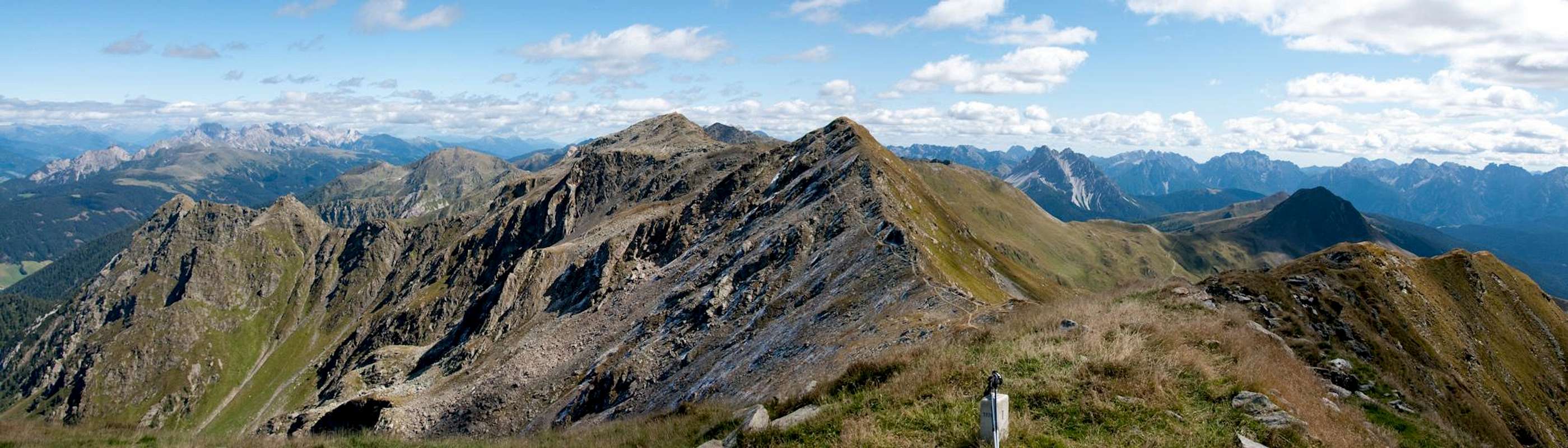
 Stage 1 of Karnischer Hoehenweg / Traversata Carnica seen from Gumriaul
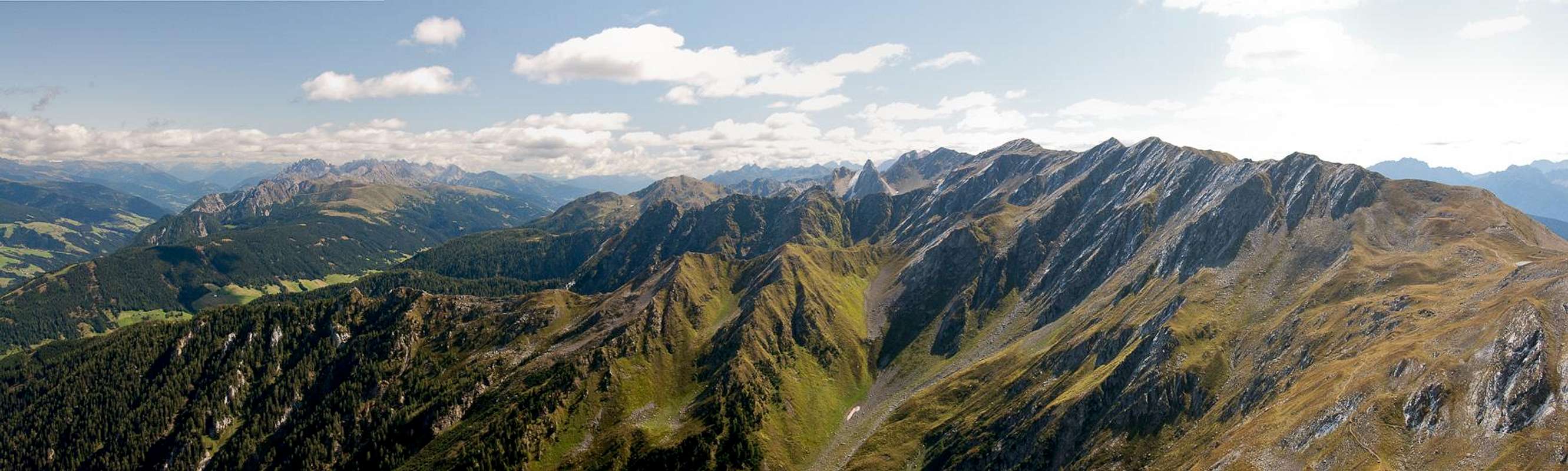
The first part of Karnischer Höhenweg / Traversata Carnica is generally considered to be the easiest one. The mountains resemble grass-covered hills at elevations between 2400m and 2650m and there are no difficult or exposed sections. However, thanks to the constant up and down, the stage is rather strenuous, resulting in an overall elevation gain / loss of some 1500m. The stage touches the following summits:
- Helm / Monte Elmo (2433m)
- Füllhorn / Corno Copia (2445m)
- Hochgruben / Tova Alto (2537m)
- Hornischegg / Monte Arnese (2551m)
- Hollbrucker Spitze (2581m)
- Pfandlegg (2381m)
- Demut / La Mutta (2591m)
- Schöntalhöhe (2636m)
- Eisenreich (2649m, 2665m, 2630m)
- Cima Frugnoni (2561m)
Of these summits only the last four lie directly on the route, while the others can be climbed by more or less short deveations.
Unlike the other stages of Karnischer Höhenweg / Traversata Carnica the first one does not separate in two distinct routes, one in Italy, one in Austria. It rather follows the old WW I trenches, which in places (e.g. near Pfandlegg are separated by only a few metres. Thus the path is rather ambiguous. The following sections will detail the ambiguous sections.
The stage will be described from west to east with the following sections:
- Helm / Monte Elmo - Sillianer Hütte - Hornischegg / Monte Arnese - Hollbrucker Spitze - Hochgraentenpass
- Hochgraentenpass - Demut / La Mutta - Schoentalhoehe / Cima di Valbella - Eisenreich - Cima Frugnoni - Obstanser See Huette
3 - Rating The Route (By Hiking Standards)
The stage runs along the Carnic Alps Main Ridge in west-easterly direction. There is only one short section in the west face of Demut / La Mutta, where you can speak of exposure. Everything else is rather easygoing. There are many ups and downs resulting in an elevation gain of roughly 1500m - if you take advantage of the cable-cars. If you start from the villages you have to add another 1200m!
4 - Getting There
 Sillianer Hütte
 Karnischer Hoehenweg / Traversata Carnica officially starts at Sillianer Hütte on the east slopes of Jochgruben / Tova Alto. It can be reached from three sides, from Sillian in the north, from Vierschach / Vesciaco in the north-west or Sexten / Sesto in the west. While you can hike to the hut, the average elevation gain is already 1200m, which would result in an additional day you have to plan for the trek.
Instead, most trekkers take advantage of the following technical help:
- From Sillian you can take a taxi to Leckfeldsattel, a saddle between Hochgruben / Tova Alto and Füllhorn / Corno Copia. From there only 200m remain to reach the hut.
- From Vierschach / Vesciaco a chair lift takes you to the west ridge of Helm / Monte Elmo. Getting to the hut requires climbing the mountain, or using the hut support road to its west.
- From Sexten / Sesto a cable-car runs to the west slopes of Helm / Monte Elmo. It is separated from the chair lift by less than one kilometre so that the same itineraries lead to Sillianer Hütte.
The following route descriptions start at the Vierschach / Vesciaco chair lift, which is the westernmost of the three access points.
5 - Route Description
5.1 - Helm / Monte Elmo - Hochgräntenpass
 Pfandlegg, Hollbrucker Spitze, Hollbrucker Egg and Zenser Spitze
5.1.1 - Helm / Monte Elmo - Sillianer Hütte
 Helm and Füllhorn above Leckfeldsattel
From the Vierschach / Vesciaco chair lift the easiest route to Sillianer Hütte follows the maintenance road for the hut. It touches the Sexten / Sesto cable-car and runs by Hahnspielhütte before starting to gradually ascend along a long ramp towards the saddle between Helm / Monte Elmo and Füllhorn / Corno Copia.A more picturesque path leads across the Helm / Monte Elmo west ridge towards the summit of the mountain (rocky scramble near the top). From there follow the east ridge to the aforementioned saddle.
Again, the easier route follows the support road to the west of the ridge, while a wonderful ridge traverse is the more strenuous and picturesque alternative. The ridge traverse touches the westernmost parts of Füllhorn / Corno Copia before descending steeply into Leckfeldsattel, where it rejoins the road. From the north, the access route from Sillian also joins here and now a few switchbacks of the road take you to Sillianer Hütte 200m higher.
Duration: 1 1/2h - 2h
5.1.2 - Sillianer Hütte - Hornischegg / Monte Arnese
 Hornischegg
From the hut follow the marked trail in easterly direction. If you want you can climb Hochgruben / Tovo Alto (15min) from the following saddle where you find a panoramic lookout-hut. Pass it and head in direction of Hornischegg / Monte Arnese. The regular trekking trail passes the mountain to its north but two routes lead up to the summit. The more difficult one scrambles up the rocky north ridge while a second easier one runs across a ramp of the west face. Both combine on the summit, from which a third route along the east ridge heads down to the trekking trail again.
Duration: 30 min - 45 min
5.1.3 - Hornischegg / Monte Arnese - Hollbrucker Spitze (Hollbrucker Egg)
 Hollbrucker Egg and Hollbrucker Spitze
Follow the east ridge of Hornischegg / Monte Arnese into a saddle, which lies above a cirque, formed by Hollbrucker Spitze, Hollbrucker Egg and Zenser Spitze. The trekking trail branches into two paths again: one runs along the south slopes of Hollbrucker Spitze along an easy path towards the saddle betwen the mountain and neighbouring Pfandlegg. The second one starts to climb the west ridge of Hollbrucker Spitze in a rocky scramble (slight exposure to the south), cuts over the ridge into the north face and heads for the saddle between Hollbrucker Spitze and Hollbrucker Egg. From here a slope traverse underneath the east face of Hollbrucker Spitze takes you back to the easier route, which it joins directly underneath the Pfandlegg saddle.
Remark: from the northern route you can climb Hollbrucker Egg, a steep, rocky path with a good amount of exposure. Duration: 45 min both ways.
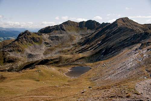
The combined routes now run along the north slopes of Pfandlegg towards the heart shaped lake in Hochgräntenjoch, where you can find the highest WW I cemetery in the Alps.
Remark: If you scramble to the top of Pfandlegg you can follow the east ridge of the mountain in a much more picturesque route towards the pass. You will find this wide ridge furrowed by trenches of the big war. The pass was of great strategic importance during the war.
Duration: 1h
5.2 - Hochgräntenjoch - Obstanser See Hütte
  |
5.2.1 - Hochgräntenjoch - Demut / La Mutta
 Hochgräntenjoch and Demut / La Mutta
From the pass follow the marked trail (several possibilities) to a shoulder. Here a combine trail starts to run through the west face of Demut / La Mutta. It soon get very steep, running in switchbacks through the face. In one place old rails, covered by a net bridge a 3m gap. The path passes a war position, carved out of the rock, where you can still observe the cupboards, installed there by Austrian soldiers 90 years ago. A few more steps take you to the east ridge of the mountain, about 20m from the summit.
Duration: 1h
5.2.2 - Demut / La Mutta - Schöntalhöhe / Cima di Valbella
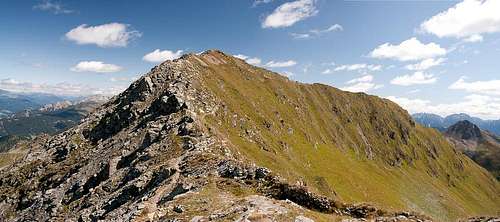 Schöntalhöhe / Cima di Valbella
From the Demut / La Mutta summit follow the east ridge. After several hundred metres you'l reach an old WW I fort - or rather its foundations. Cross to the far side of the fort, where the path heads on towards Schöntalhöhe / Cima di Valbella. As you reach the saddle between the mountains, two possibilities open up. A southern route runs through the south face of the mountain, making use of the WW I trenches. It heads for the next saddle, which separates Schöntalhöhe from Eisenreich. A second route follows the west ridge towards the summit of Schöntalhöhe.
Duration: 30 min
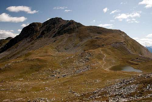
5.2.3 - Schöntalhöhe / Cima di Valbella - Obstanser See Hütte
 |
Remark: I have not hiked this part of the route!
Follow the east ridge of Schöntalhöhe into the saddle, which separates it from Eisenreich, where the south face route joins. Through the whole Eisenreich massif with its three summits there are at least two possible routes, running through the south or north faces or scaling the ridges to the summits. None of the routes is difficult in any way as the mountain is absolutely harmless.
From the last Eisenreich summit Karnischer Hoehenweg / Traversata Carnica heads down in western direction to Obstanser See and Obstanser See Hütte. A second route runs along the main ridge and across Cima Frugnoni towards Obstanser Sattel, from where a second descent route leads to the lake and hut.
Duration: 1 1/2 - 2h
6 - Mountain Huts
There are three huts on this stage of the trek:While the first two can be most easily reached as described in the getting there section, the latter can be reached by a long hike from Kartitsch in Austria through Winklertal.
Along the route - to the north and south of the ridge, a good number of small haystacks can be found in case you need instant shelter.