
-
 5751 Hits
-
 78.27% Score
-
 9 Votes
|
|
Route |
|---|---|
|
|
46.67533°N / 12.52411°E |
|
|
Hiking |
|
|
Summer, Fall |
|
|
Most of a day |
|
|
Medium hard hike |
|
|
General Overview
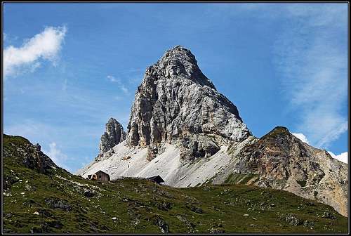
Grosse Kinigat / Monte Cavallino from the SE

Obstanser See and its hut
The main crest of Carnic Alps is ideal for a long-distance trek. Karnischer Hoehenweg / Traversata Carnica goes along all its 140 kilometers, from Sillian or Sexten on the west to Thoerl/Maglern on the east. Often the route goes separately on the northern, Austrian side of the ridge (Karnischer Hoehenweg) and on the southern, Italian side (Traversata Carnica). In the western half, its daily stages could be the following ones:
1. Innichen or Sexten or Sillian - road or cablecar to the trailhead - Sillianer Huette - Obstanser See Huette. 6 h 30 min.
2. Obstanser See Huette - Porze Huette. 7 h.
3. Porze Huette - Hochweißstein Haus or Rifugio Calvi. 8 h 30 min.
4. Hochweißstein Haus or Rifugio Calvi - Eduard-Pichl Huette - Ploecken Pass / Passo di Monte Croce Carnico. 10 h.
General About Stage 2
As described on the pages of: Pfannspitze / Cima Vanscuro, Kleine Kinigat / Monte Cavalatto, Grosse Kinigat / Monte Cavallino and Porze / Cima Palombino, in this section the Karnischer Hoehenweg goes partly on the northern side of the ridge and Traversata Carnica partly on the southern side. In the section between Obstanser See Huette and Standschuetzenhuette the trek goes by the main ridge and only a side branch goes by the Austrian side. From Standschuetzenhuette to Porze Huette Karnischer Hoehenweg and Traversata Carnica go separately, one on the northern side and the other one on the southern side of the main ridge. By the main ridge in this section a ferrata (C. D'Ambros) goes, but it is not considered to be the usual part of the stage. Even if it is not much longer (but more difficult), hikers usually go by the Austrian or Italian side. The Italian route then ascends the summit of Porze / Cima Palombino, but then again goes deep down on the southern side, not reaching at all Porze Huette, but continuing over the alpine meadows avove Val Visdende.
Here the stage will be described from west towards east, the sections will be:
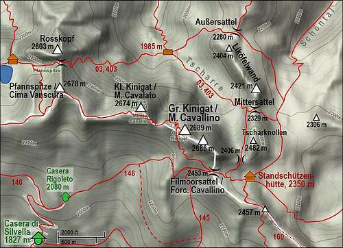
- Obstanser See Huette - Pfannspitze / Cima Vanscuro - Grosse Kinigat / Monte Cavallino - Standschuetzenhuette. So, in this part all the time panoramic, by the main ridge.
- Standschuetzenhuette - Heretriegel - Porze Huette. So, in this part by the Austrian Karnischer Hoehenweg.
Rating The Route (By Hiking Standards)
The grading system for hiking and scrambling routes is here.
0. General: many ups and downs with some 1000 meters of altitude up and some 1300 meters down. The path goes manily by the main ridge (W-E direction), on Grosse Kinigat / Monte Cavallino we ascend by the W face and descend by the S ramp. On the stage there are also passages over the W, N and E slopes (important for winter ascents, when under snow). Gear: good hiking shoes and poles.
1. Effort: cca 1250m, many ups and downs, 7-8 hours.
2. Power: 1 - No difficulties, if we avoid Grosse Kinigat / Monte Cavallino. 2 - Easy if we ascend it (ferrata up and down).
3. Psyche: 2 - Easy (a few exposed, but secures passages), 3 - Medium, on Grosse Kinigat / Monte Cavallino.
4. Orientation: 1 - no difficulties, well marked.
Getting There
To get to the start of the whole Carnic trek, you must of course reach Innichen or Sexten or Sillian. See the main Carnic Alps page how to get there. But only for stage 2, you can take the two approaches:
1. From Kartitsch in Tiroler Gailtal. In the town deter south and drive by Winkler Tal (valley) till the altitude of cca 1400 m, where you park at sport parc (tennis courts). The road further on to Obstanser See Huette (3 hours) is closed for public trafic. By the road you hike some 1500 meters, arriving to a big, steep, rocky valley step. You need to do some 500 meters to ascend over it. The path is broad, very comfortable, because in the World War I it was used as a supply path for the frontline. Exiting the rocky face you reach the cute Prinz Heinrich Kapelle, 1957 m. There nearby also a hut stands, which is permanently opened and can be used to sleep there in emergency. Now the flat Obstanser Boden (plane, alpine meadow) is in front of you. You cross it towards the S, keeping closer to its E (left) side. After you pass the last shepherds huts (ruines), the valley has another step. You ascend steeper again, in many turns crossing the screes below the NW face of Rosskopf. On the right you can clearly see the Eishoehle - a cave where long in summer snow rests can be found. Finally we reach top of this valley step where Obstanser See Huette stands. 3 hours from the parking place.
 |
 |
 |
 |
 |
2. From Val Padola. This is the valley delimiting Sexten Dolomites from Carnic Alps. There the main road goes over Passo Montecroce Comelico / Kreuzbergpass. On the SE side of the saddle (altitude 1328 m) you can take a mountain road ascending northwards to Malga Colrotondo, 1879 m, where you will find the last parking place. From the hut you can start hiking, first towards the E, then towards the N, reaching thus the main Carnic Alps ridge on Sella di Frugnoni. You have now some 250 m to descend to Obstanser See Huette, or, if you are in the morning, just continue hiking by Traversata Carnica towards the E. From the parking place good 2 hours to Obstanser Sattel, where the N and S approach meet.
See also the page of Pfannspitze / Cima Vanscuro!
Route Description
Obstanser See Huette - Pfannspitze / Cima Vanscuro
From the hut, 2304 m, you take the marked path (No. 5a) which goes by the western shore of the lake towards the south. After you pass the lake, you start ascending gentle grassy slopes, coming soon to the World War I graveyard, cca 2380 m. From there, you have a nice view on the lake, the hut and the rocky Rosskopf behind. Then you continue southwards and in another good 100 meters of altitude reach the main Carnic Alps ridge on Obstanser Sattel / Forcella Pala dei Orti, 2506 m. A great view on Sexten Dolomites opens there.
From the saddle you continue eastwards by Traversata Carnica (No. 160). You first ascend point 2579 m and continue from it towards the S-SW ridge of Pfannspitze / Cima Vanscuro. The ridge bumps here are rounded and mostly grassy, only towards the summit of Pfannspitze / Cima Vanscuro, 2678 m, you need to climb over a few rocks. No big exposure, only some more care is needed on the more narrow path. You are now on the very panoramic, second highest summit of today's etappe. 1 hour from the hut.
 Obstanser See |
 Pfannspitze / Cima Vanscuro SW ridge |
 On Pfannspitze / Cima Vanscuro |
Pfannspitze / Cima Vanscuro - Grosse Kinigat / Monte Cavallino - Standschuetzenhuette.

The descent by the SE ridge of Pfannspitze / Cima Vanscuro and the continuation by the ridge further towards the E on the S slopes of Kleine Kinigat / Monte Cavalatto is very gentle and panoramic. Below Kleine Kinigat / Monte Cavalatto the rocks structure changes abruptly. From older, paleozoic rocks we suddenly get to white, brittle limestone. Being just below the summit of Kleine Kinigat / Monte Cavalatto, we don't see the path up on it. The ascent is pathless and requires some easy rock climbing, degree UIAA I/II (I haven't done it). Traversata Carnica now descends to Sandiger Boden, the saddle between Kleine Kinigat / Monte Cavalatto and Grosse Kinigat / Monte Cavallino (many WW1 rests there). Here you must decide whether to ascend the summit of Grosse Kinigat / Monte Cavallino or not. A 1 hour detour (up and down) is highly recommendable, continuing by the southern side of the mountain you would miss the biggest attraction of the stage. 45 minutes.
 Pfannspitze / Cima Vanscuro and Rosskopf |
 Approaching Grosse Kinigat / Monte Cavallino |
The ascent on top goes over the W face, by the so called War Trail Ferrata. It is well protected, but requires some care because rock is brittle and if there are many hikers in the ferrata there's some danger of falling stones. The difficulty of ferrata is a low one, just the same as the South Face Ferrata on Grosse Kinigat / Monte Cavallino. Climbing over it I was surprised by beautiful layers of marble. I had a feeling to be climbing over the walls of a nice cathedral. After some 100 meters you are out of the W face, you already see the summit rocks and the cross in the distance. Also on this high summit plateau you will see many rests from the WW1. To the top, 2689 m, you have 45 minutes from Sandiger Boden.
 Towards the summit of Grosse Kinigat / Monte Cavallino |
 Below the summit of Grosse Kinigat / Monte Cavallino |
Ascending on top from the W you passed just below the summit the exit of South Face Ferrata. Now you descend to that point and deter left down. The ferrata follows a steep ramp, made of brittle rock, again marble-like. It is again well protected, you mostly can hold on the cable, or walk carefully on the outside side, when meeting people climbing up. The ramp is short, after some 100 altitude meters of descent you are already out on the scree fields. Below you see Traversata Carnica crossing them, but the path we are on, goes some 50 meters above it, joining it only after we pass the picturesque Königswandtürml (tower). Then we descend to the grassy Filmoor saddle, 2453 m, and further down to Standschuetzenhuette, 2350 m. Less than 1 hour from the summit.
 Descending by the S face ferrata |
 Grosse Kinigat / Monte Cavallino S face ferrata |
 Koenigswandtuerml |
Standschuetzenhuette - Oberer Stuckensee - Heretriegel - Porze Huette
From Filmoor saddle towards the SE, the main Carnic Alps ridge gets quite sharp. The first elevation in it is Filmoorhoehe, 2457 m, then many tower-like summits are following until finally the ridge ascends on the high summit of Wildkarleck / Cima Vallona, 2532 m. Over this crest a ferrata, marked with No. 191 goes. Further on, Traversata Carnica goes by the southern side first on Porzescharte / Passo di Cima Vallona, 2362 m, and then by the NW and W ridge (ferrata again) on Porze / Cima Palombino. As we haven't done this part, and as it is not an 'official' part of the long-distance trek, I can not describe it more in detail. So, let's go by the northern, Austrian side!
 On Filmoorhoehe |
From Standschuetzenhuette (good vegetable soup with young cheese there!) the marked path No. 03 and 403 goes down towards the SE, allways below the Filmoorhoehe ridge. The nature of rocks changes again, limestone is replaced again by harder rocks which hold water. So everywhere water sources can be seen, all streams flowing down into Oberer Stuckensee. In a long arc the path descends down, finally going in the NE direction. We lose good 300 m of altitude, finally finding ourselves by the lake, on 2032 m.
 Below Filmoorhoehe |
 Oberer Stuckensee |
It depends on you if you will take a swim or not in a cold water, but have in mind that ahead of you there's an ascent again. The path goes in the NE direction across the broad slopes, gaining altitude only a little. When we reach just below Heretriegel (the saddle between Heretkofel and Wildkarleck /Cima Vallona), the path does a few more steep turns and we are above. The view on the end of Obertilliachertal and on Porze Huette opens.
But if you think that down to the hut you have only to descend, you are wrong! Karnischer Hoehenweg goes over the slopes of Wildkarleck /Cima Vallona some time still ascending. So, we continue from the saddle in the SW direction, then horizontally towards the S, then ascending some 50 meters towards the SE. There, big electricity towers stand, the wires are going across the state border. From the side ridge of Kesselhoehe / Col de l'Ai we finally descend, first steeply (even one place secured by pegs), then more comfortably, losing good 100 meters of altitude. In the valley we hit the path, where most of people go from Porze Huette on top of Porze / Cima Palombino. Now we need to cross the slopes towards the hut. There are many small ravines and ridges, the path goes mostly horizontally, but is quite unpleasant. Finally we need to ascend again some 30 meters and the hut is here. From Standschuetzenhuette some 3 hours.
 Stuckenwiesen |
 From Heretriegel towards Porzehuette |
 Porze / Cima Palombino from the N |
Mountain Huts

Filmoor Standschuetzenhuette

Obstanser See Huette
- Obstanser See Huette, 2304 m. Reachable in 3 hours from Kartitsch. 60 places to sleep, opened from mid June till the end of September. Tel.: +43(4848)5422, +43(0664)1618723. E-mail: bhp@tirolspeed.com
- Filmoor Standschuetzenhuette, 2350m. From Leiten, west of Obertilliach, we hike southwards through Leitner Tal. 3h 30 min to the hut.
- Porze Huette, 1942m. Reachable in 45 minutes from the parking place in Obertilliacher Tal. 60 beds, opened from mid June till end September. Telefon (hut): +43/664/4038929. Telefon (valley):+43/4847/5243. Mobile: +43/664/4038929. E-mail: sport.auer@aon.at.
Many (shepherds) huts on alpine pastures south of the ridge.