
|
|
Route |
|---|---|
|
|
35.26000°N / 115.308°W |
|
|
Download GPX » View Route on Map |
|
|
Scrambling |
|
|
Spring, Fall |
|
|
Most of a day |
|
|
Class 3 |
|
|
Overview
Keystone Canyon provides a simple way to reach the summit of New York Mountain, a craggy DPS goal. The roads are generally pretty good, and most of the hike is class 1 on an old, unobtrusive mining road, with a short stretch of talus and some class 2 past the mine and on the ridge. The last 200’ of elevation gain is class 3+ (if you stay on route), to class 5 (if you miss the route)Getting There
From i-15, take the Nipton/Searchlight exit. This exit is east of Mountain Pass, CA, and SSW of Primm, NV. After leaving the exit ramp, drive 3.4 miles east on the “Nipton Road”, and turn south (right) on the Ivanpah Road. Take the good Ivanpah Road for 18.1 miles, to a right (SW) turn onto a faint gravel road. The coordinates of this turn, relative to WGS84, are 35.27995, -115.24761.Travel SW on this gravel road a very short distance to a fork, and bear left at the fork. Shortly the road curves to a westerly direction. Stay on the main gravel road, ignoring at least one additional very faint right fork. Another road bears left ~0.6 to 0.7 miles in; DON'T take this left. Follow the best road and your instincts, into the canyon.
How far you go on this last gravel road depends on: 1) recent storms; 2) your car; and 3) how much you value your car. I went in 2 miles and parked before a wash crossing (labeled “2WD Park” on the map at left below). Most decent-clearance 2WD vehicles could make it this far (as of Jan. 2007), if driven slowly and carefully. From that point (2 miles in), the hike is only 6.4 miles round trip, mostly on old mining roads, with 2500' accumulated elevation gain. So you needn’t tempt fate too much.
 100k map 100k map | 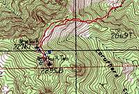 24k map 24k map |
Route Description
From the parking spot, follow the old mining road generally SW as it meanders through Keystone Canyon. You will see crags ahead, but most are actually NE of the true summit. (In places, the "road" is barely different from a stream bed.) The road turns south for ~1/3 mile, then abruptly hits a fork. You do NOT want the branch that continues SSE to Keystone Spring; you DO want to keep right and travel SW, then W up the canyon. Eventually the route steepens, passes an old mine tailings pile, and pretty much ends. From here, follow the talus (with occasional pretty green and blue rocks) up and on the left side of the canyon, till you reach a saddle in the ridge at ~2060 m elevation. West on mining road West on mining road | 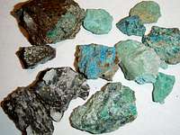 Cu-Zn minerals Cu-Zn minerals |
From the 2060 m saddle, travel west up the ridgeline, eventually turning SW to the top of the lower northern peak. From here, look SE to the higher, craggy true summit, as shown in photo A (left, below). Examine the small scale (1:24k) topo map above to locate positions A, B and C.
Identify the routes shown on photo A (which was taken at point A on the 24k topo map). Travel SE to the location indicated as point B on the 24k topo map above. Point B yields the view seen in the middle photo below; the coordinates of this point (relative to WGS84) are 35.25970, -115.31170. From B, identify the "balancing" rock (really wedged between two granite slabs), and travel up the path in photo C. (to get to this view, you will need to follow a sandy path west between high boulders, to a blind gap that opens up on your left, to this first climb.) At the top of this stretch, you will step right onto a higher rock, then you will turn slightly left and travel over class 2 (but exposed) terrain to a slot (crack) in the granite (indicated in photo A).
 photo A photo A |  photo B photo B | 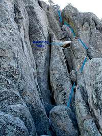 photo C photo C |
Near the slot, you may get a good view east to Hart Peak (left photo, below). At the south end of the slot, climb up, then down and cross a depression to the bottom of the last chute (middle photo below). The chute looks tougher than it really is – as long as the rock is dry. Partway up the chute, to the east (left) you will see a “window” through the granite (right photo, below).
 Hart in distance Hart in distance |  D, last chute D, last chute |  Window in chute Window in chute |
At the top, you will find a DPS register, very little room to move around, and splendid views.
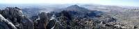 View south View south |
Essential Gear
Some people may want a belay (or at least a hand line) for the descent of the top chute. A large sling can be positioned around a boulder near the top of the chute, but potential anchors are scarce. There are, however lots of cracks for cams and whatnot. It would be good to take at least 50’ of 2800-4500 lb-test webbing, or an equivalent rope, as well as enough webbing for a sling.This is a dry hike, so bring plenty of water. Remember, however, that the top ridge is over 7000' elevation; winters can be quite snowy. The summit was below 30F on my visit. The class 3 route is shaded, so watch for ice in winter months.
External Links
I like Andy Zdon's books; they give the "big picture", plus enough detail to get you to the hike.Desert Summits by Andy Zdon
As a rule, I won't make an SP page for a route or mountain that is covered in Desert Summits, unless I can improve on the description. In this case, enough people were mystified by the last 200' vertical (and the "class 3" chute), that I felt a more detailed description was in order.