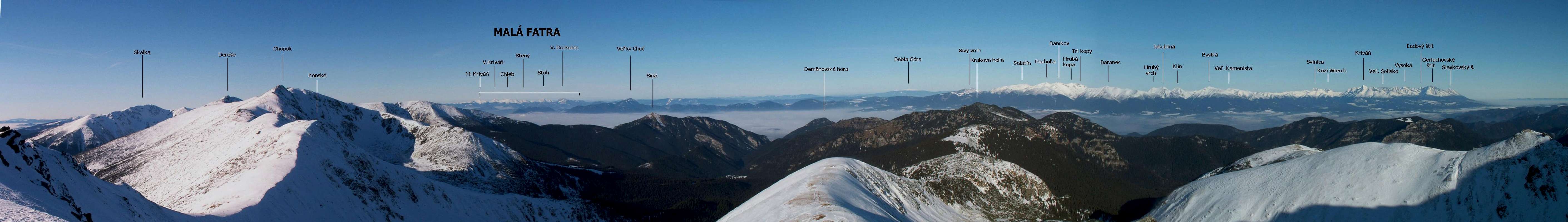
One of the most conspicuous massifs of the limestone belt of the Lower Tatras (Nízke Tatry), Krakova hoľa sits 5 km north of Ďumbier, their highest peak. Krakova hoľa looks especially attractive from the north, i.e. from the basin of Liptov. (The mountain first beckoned me while I stared at the Lower Tatras from the train.) Krakova hoľa has three distinctive summits, of which you can only set foot legally on the highest, southwestern peak. Even though its summit area is covered by a wonderful sea of dwarf mountain pine (Pinus mugo) up to 2.5m tall, it offers a panoramic view: All mountain ranges surrounding Liptov can be seen.
SW view
NW view
N view
NE view
E view
And just south of the main vantage point on the rim of the bluff, where the southerly view is obscured by the bushes of dwarf pine, one can get the best views of the massif of Ďumbier. Besides being an excellent vantage point, Krakova hoľa is away from the Lower Tatras' main ridge, whose central part is usually packed with people arriving by cable car (see here). The trail traversing the eastern slopes of Krakova hoľa (blue marks) runs through what can be called the Carpathian wilderness, where – except in July and August – it seems that you are more likely to run into a bear than into another hiker.
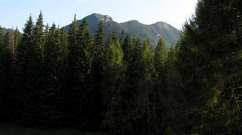
The massif of Ďumbier seen from Krakova hoľa
Lastly, climbing Krakova hoľa can be a reasonable option for those who are unsure of their walking potential, e.g. for someone recovering from illness or injury - a return would be relatively easy and brief. On the other hand, if you feel like extending your hike, this can be done by ascending Poludnica or Ďumbier on the same day, which would make for a full day of hiking.
Trails
The trails climbing the slopes of Krakova hoľa are waymarked either blue or yellow. (Please see the online map in the next chapter.) The last stretch of an ascent is a short dead-end path from a trail junction named "Pod Krakovou hoľou". The table below compares ascents via - all or most of the time - blue marks with the most convenient starting points in either of the main valleys: Demänovská dolina to the west and Jánska dolina to the east of the long lateral ridge which branches off the main ridge of the Lower Tatras at Krúpova hoľa (at the west end of the Ďumbier Massif) and runs north to Krakova hoľa and then farther on to Poludnica.
Car park at Lipt. Ján-Spa, NE of Krakova hoľa, bus terminal
approx. 1,100
nearly 4 hr; Class 1, occasionally 2
wild parts, a bit strenuous, above tree line path under assault from dwarf pine
green then blue
The summit of Krakova hoľa can also be ascended from the south, via the saddle of Javorie (1479m), with which it is connected by a trail marked yellow. However, a route through this saddle seems to be a better option for a descent, especially when it is about to be getting dark and you are heading for the Jánska Valley. From Javorie the yellow trail runs on south as far as the main ridge (less than 2 hours' walk away), whereas the red marks drop west and east, into the valleys. It should take you about 40 minutes to get from the summit of Krakova hoľa to Javorie. From there you should reach the bus stop at a place called Lúčky (which translates as "little meadows") in the Demänovská Valley in less than five quarters of an hour while a stroll east and then north down the road (a reasonable option after dark) to Liptovský Ján will take about three hours. The shortest round trip to the summit of Krakova hoľa - about four hours' walk - would be: Lúčky-Javorie Saddle-Krakova hoľa-Pusté-Demänovská Cave of Liberty.
The Lower Tatra Mountains are protected as a national park.
Camping within the area in question is not permitted. You are supposed to stick to the waymarked trails.
In Slovakia those who do not carry commercial insurance have to pay for any rescue services rendered by Mountain Rescue Service (HZS).
No water can be found along the trails on the slopes of Krakova hoľa, so it is a good idea to make sure you have enough water in your backpack, especially on a hot summer day.
Getting There & Accommodation
Liptovský Ján
Liptovský Mikulaš, the capital town of the region is easily accessible by both road (D1 motorway) and rail (one of the oldest railway lines in Europe; several Intercity and fast trains a day). The distance between Liptovský Mikulaš and the trailheads is less than a dozen km.
Parents refers to a larger category under which an object falls. For example, theAconcagua mountain page has the 'Aconcagua Group' and the 'Seven Summits' asparents and is a parent itself to many routes, photos, and Trip Reports.

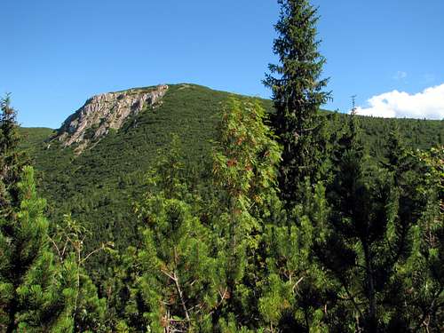


 S face of Krakova hoľa
 Seen from Krúpova hoľa
 Seen from SE
 Liptovský Ján