
-
 5513 Hits
-
 84.82% Score
-
 19 Votes
|
|
Mountain/Rock |
|---|---|
|
|
47.18108°N / 11.04263°E |
|
|
Hiking, Skiing |
|
|
Spring, Summer, Fall, Winter |
|
|
9688 ft / 2953 m |
|
|
Overview
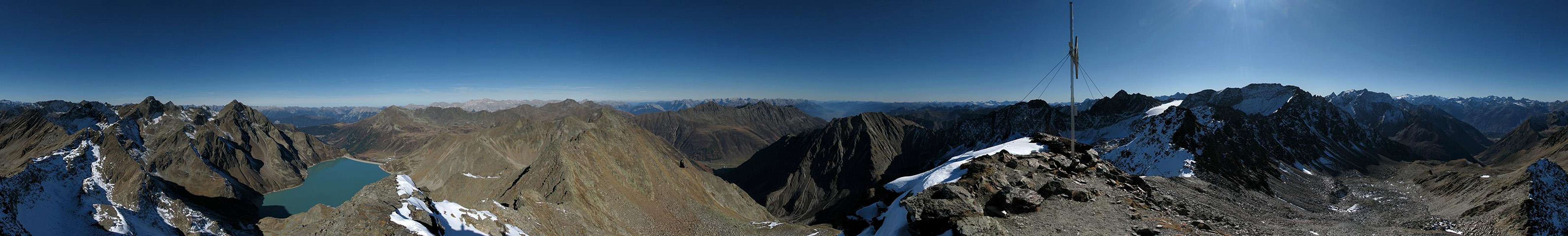
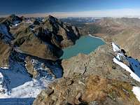 Finstertal Reservoir
The mountain is placed within a great part of the Sellrain mountains. The summit offers a splendid view around. Across the Sellrain valley you have a look onto Wetterstein and Lechtal Alps. Looking over the Öztal valley to the south-west the heart of Öztal Alps with Wildspitze is clearly visible. Only directly to the south, Zwieselbacher Rosskogl quite blocks the view. Although the view is not as spectecular as from Sulzkogl the mountain is not crowded that much which is quite an advantage.
The summit cross of Kraspesspitze is placed on an unnamed peak nearby. According to the AV map the true summit of Kraspesspitze is a few meters lower and a bit more to the south. I think the reason for this is, that this "false" summit is visible from the valleys. Additionally the views from the summit cross are fine since you see the Finstertal Reservoir, which isn' t visible from the real summit.
Maps And Routes Overview
Maps:
Routes:
|  Kraspessee Kraspessee From Finstertalscharte From Finstertalscharte |
Panoramic Views
  |
Mountain Conditions
Weather:
- www.wetter.com
Long-term, but sometimes inaccurate weather forecast for the city of Kühtai. - ZAMG
Quite accurate five day forecast. - OEAV weather forecast
Weather forecast especially for mountaineering porpuses. Unfortunately this page is available in german only. - Avalanche report (Tyrol/Austria)
There is a link on the left side of the page to the english version of the avalanche report (PDF format).
Webcams:
 | http://www.mittergrat.at/wettkam.htm The first webcam is at Dortmunder hut looking west. The second must be placed somewhere close to Drei Seenhut looking towards Pirchkogel (to the north). The next one looks towards Gaißkogel/Pockkogel from Drei Seenhut. The last webcam shows the Chruch of Kühtai. |
Getting There
There are mainly two ways to get to Kraspesspitze:- From the north via the Sellrain road through Kühtai
- Via the Öztal valley to the west
Both approaches start at the Inntal valley which has a good highway connection to Switzerland, Italy and Germany. The Öztal valley has a direct connection to Italy via the Timmesjoch pass (which is closed because of its height of close to 2500m during the snowy months).
If coming via the Sellrain valley you have to drive to the village of Kühtai. There are enough places to park and I haven' t seen that you have to pay for parking. From the main road several trails lead up the south slopes up to the Finstertal Reservoir.
The approach via Öztal leads you to the small town of Umhausen where the road to Niederthai splits from the main road. After reaching Niederthai you have to cross the river to the left to reach the parking lot. The trail towards Kraspesspitze starts at the bridge you' ve crossed to get to the parking lot following the river.
Using public transportation it is quite complicated to get to the trailheads and takes a long time. Your only chance is bus #4166 driving from Innsbruck to Küthai. Additionally bus #4196 connects Kühtai with Imst. Both Imst and Innsbruck have access to the railroads of the Inntal providing connections to Switzerland, Italy and Germany as well as to other parts of Austria.
For more information abouth austrian trains/buses visit the homepage of the ÖBB (unfortunately in german only).
Red Tape
There are no permits, fees or seasonal closures.Parking at the parking lots at Kühtai is free. During the summer months you won' t have problems getting a place to put car. I guess it' s completely the opposite during the winter with the ski-area running. I don' t have information about the parking lot at Niederthai.
Camping
Camping is not forbidden in the area and there is are two huts close to the mountain:
|  Dortmunder hut Dortmunder hut |
When To Climb
Kraspesspitze is visited the hole year. Since Sulzkogl which is quite near is a bit higher and offers the better views, Kraspesspitze is quite neglected. But if you choose quietness Sulzkogl is not your choice...
Literature
- Stubaier Alpen
Walter Klier
Alpenvereinsführer
Rother Verlag (www.rother.de)
ISBN: 3-7633-1271-4
External Links
- http://www.austrianmap.at
On the left side of the page is an input form. If you enter Kraspesspitze and click on go you get two results. Double clicking on one of the results focuses the map on the summit of Kraspesspitze.