
-
 6486 Hits
-
 84.82% Score
-
 19 Votes
|
|
Mountain/Rock |
|---|---|
|
|
47.16416°N / 11.04744°E |
|
|
Hiking, Mountaineering, Skiing |
|
|
Spring, Summer, Fall, Winter |
|
|
10112 ft / 3082 m |
|
|
Overview
 Beautiful streams...
 ...little lakes...
Since the mountain is one of the highest of the norther Sellrain area, the views to the north, east and west are perfect with no higher moutain close. To the south the views get stopped quite short by the higher southern Sellrain mountains. But this still provides spectecular views into the Stubai Alps and Öztal Alps. Taking it all together the summit offers a beautiful 360° panorama which is worth enjoying a while.
One of the negative aspects of Zwieselbacher Roßkogel is its popularity. It is frequently visited the hole year. During the summit months mostly via the souther routes. In winter the norther route from Haggen offers a long but splendid skitour with beautiful slopes and great views along the valley.
Maps And Routes Overview
Maps:
Routes:
|  ... and bigger lakes. ... and bigger lakes.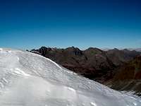 From Schöntalspitze From Schöntalspitze |
Panoramic views
  |
Mountain Conditions
 Kraspesferner
Weather:
- www.wetter.com
Long-term, but sometimes inaccurate weather forecast for the city of Kühtai. - ZAMG
Quite accurate five day forecast. - OEAV weather forecast
Weather forecast especially for mountaineering porpuses. Unfortunately this page is available in german only. - Avalanche report (Tyrol/Austria)
There is a link on the left side of the page to the english version of the avalanche report (PDF format).
Webcams:
 | http://www.mittergrat.at/wettkam.htm The first webcam is at Dortmunder hut looking west. The second must be placed somewhere close to Drei Seenhut looking towards Pirchkogel (to the north). The next one looks towards Gaißkogel/Pockkogel from Drei Seenhut. The last webcam shows the Chruch of Kühtai. |
Getting There
There are mainly two ways to get to Zwieselbacher Roßkogel:- From the north via the Sellrain road through Kühtai
- Via the Öztal valley to the west
Both approaches start at the Inntal valley which has a good highway connection to Switzerland, Italy and Germany. The Öztal valley has a direct connection to Italy via the Timmesjoch pass (which is closed because of its height of close to 2500m during the snowy months).
If coming via the Sellrain valley you have to drive to the village of Haggen. A small road on the south (valley) side of the Sellrain road leads down to the small parking lot. From there a trail leads directly to the south into the Kraspestal.
The approach via Öztal leads you to the small town of Umhausen where the road to Niederthai splits from the main road. After reaching Niederthai you have to cross the river to the left to reach the parking lot. The trail towards Zwieselbacher Roßkogel starts at the bridge you' ve crossed to get to the parking lot following the river.
Using public transportation it is quite complicated to get to the trailheads and takes a long time. Your only chance is bus #4166 driving from Innsbruck to Küthai. Additionally bus #4196 connects Kühtai with Imst. Both Imst and Innsbruck have access to the railroads of the Inntal providing connections to Switzerland, Italy and Germany as well as to other parts of Austria.
For more information abouth austrian trains/buses visit the homepage of the ÖBB (unfortunately in german only).
Camping
Camping is not forbidden in the area and there are two huts close to the mountain:- Guben Schweinfurter hut (2034m/6673ft)
Open from mid February to mid May and from mid June to beginning of October (additionally some days around christmas)
Internet: http://www.dav-guben.de/body_huette.html - Neue Pforzheimer hut or Adolf Witzenmann Haus (2308m/7572ft)
Open from mid February to mid April and mid June to end of September.
Internet: http://www.alpenverein-pforzheim.de/pages/huetten/pfhuetteneu.html.
Red Tape
There are no permits, fees or seasonal closures.Parking at the small parking lot at Haggen is free. But if you intend to park there make sure to get there early (especially in winter) since there is not much space (maybe up to 20 cars with a lot of squeezing). I don' t have information about the parking lot at Niederthai.
Literature
- Stubaier Alpen
Walter Klier
Alpenvereinsführer
Rother Verlag (www.rother.de)
ISBN: 3-7633-1271-4