
|
|
Route |
|---|---|
|
|
46.42000°N / 13.80000°E |
|
|
Hike and rock climbing |
|
|
One to two days |
|
|
Hike with ferrata sections |
|
|
Route Description
Krnica valley route: 6-7h
As any Razor ascent, this one is also long and tough. It contains very exposed ferratta section: Kriska Stena face. This is not for dizzy people, while it is very attractive for those with clear head for heights. This is probably most natural Razor ascent during which you have opportunity to observe it most powerful side, northern face. It is very tough to this route in one day. The best option is to sleep at Pogacnikov Dom hut and return next day.
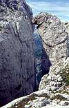
Starting point of the route is Koca v Krnici hut (1113m), which lies in Krnica valley. The valley is beautiful, with stunning scenery. All around are some of the highest peaks of Julian Alps that fall into the valley with huge walls: Skrlatica (2740m), Rakova Spica (2545m), Razor (2601m) and Prisojnik (2547m). Krnica ends with probably most beautiful amphitheater in Julian Alps – Kriska Stena.
Hut is accessible from Kranjska Gora to Vrsic pass road. Junction towards the hut is some 2 kilometers behind Kranjska Gora, just at the bridge where main road crosses over Pisnica river to the right, you continue straight. From the bridge is 3 kilometers to V Klinu pasture where you have to park. From here is 20 more minutes to the hut. If you are on foot from Kranjska Gora you will need 1.30-2h.
KRNICA HUT – POGACNIKOV DOM HUT: 4-5h
From the hut path gradually ascends up the valley till it reaches the foothills of Razor’s impressive north wall. From here it becomes steeper. Path passes by a source. Valley is becoming narrower all the time till its completely closed by impressive Kriska Stena, rounded, 400 meters high wall. It feels like at the bottom of a well as you stand at the V Kotu, scree and rocky plateau at the end of a valley, which is strewn by huge boulders.
Path turns left, ascending over scree slopes, which are usually under snow, till it reaches the cliffs. Face is climbed in many zigzags because path if following natural week passes. It is very exposed and not especially well secured so you have to be careful. Not for dizzy ones. After an hour of climbing you reach the edge of the face and step onto the ridge. Altitude is 2290 meters and views are wide. 3 hours from the hut.
Path turns right and ascends in sharp bends to Bovska Vratica pass (2375m). Wide view towards the south opens. Razor is just across the huge gaping depths of Kriska Stena basin. Sadly, now you have to descent all the way to Pogacnikov Dom hut and loose over 300 vertical meters. Just by the edge of Kriska Stena face path descends till it leaves it and turns left, traversing the steep scree slopes above the beautiful Zgornje Krisko jezero (Upper Krisko jezero lake, 2158m). From here you have 2 options to reach, from here visible, Pogacnikov Dom hut. One is going directly towards it while the other descends to the lake and joins previous little bit lower. Anyway, you should reach the hut in an hour, over bare rocky terrain. 4-5 hours from Krnica hut.
POGACNIKOV DOM HUT – RAZOR: 2h
From Pogacnikov Dom hut table will direct you towards Razor and Vrsic, on the west. You can’t mistake that we are going into huge, steep scree basin between Planja (2447m) on the left and Razor (2601m), on the right. Between them is Planja pass (2349m). After some time on the flat path reaches the scree slope bellow Razor’s SE tower. It begins to climb steeply over scree and short section of secured cliffs. Behind this path enters mentioned scree basin. This is very wild place. You ascent steeply all the way to the pass that is reached after some 1.20h. Beautiful view opens towards the west and massive Prisojnik (2547m), which occupies half of the horizon.
On the left is Planja (2447m). We turn right as path ascends steeply over scree to the cave with everlasting snow. Here it turns right and reaches southern shoulder of Razor. View towards Skrlatica (2740m) opens here. Deep behind you (left of Planja) is Zadnjica valley, side valley of Trenta with 1500 meters high western face of Kanjavec (2568m) above it. Path turns left and climbs straight to the summit over broken cliffs (40 minutes from Planja pass). 2 hours from Pogacnikov Dom hut.
View from the summit is very wide on all sides. Some 2000 meters bellow is Trenta valley and shiny Soca River. Triglav shows you its most beautiful face.
 |  |  |
Essential Gear
In the period without snow (end June till October) usual hiking gear + helmet and ropes (if you wish) for ferrata sections. In snowy period everything from ice axe, crampons, and helmet to ropes. And of course, don’t forget to take lot of experience with you.