
-
 34658 Hits
-
 89.01% Score
-
 28 Votes
|
|
Mountain/Rock |
|---|---|
|
|
14.80633°N / 61.16807°W |
|
|
Hiking |
|
|
Spring, Summer, Fall, Winter |
|
|
4577 ft / 1395 m |
|
|
The Mountain
Every so often, a debate gets going on the Summitpost forums about what is the world's most dangerous mountain. The Eiger, K2, Annapurna, even New Hampshire's Mount Washington have had their champions. But if you're measuring by how many people have actually been killed on that mountain, Pelée is the hands-down winner of this contest. This is a mountain that has reached out and snuffed out more than 30,000 people right on its flanks. A couple of other mountains, such as Krakatoa, can claim more indirect victims, killed by tsunamis and famines they caused. But of all the mountains in the world, Pelée is the queen of instant death.
There were a lot of warnings of Pelee's great eruption in 1902, which weren't heeded. Today, assuming the gendarmes haven't barricaded the approaches, you can climb with no worries. If you do, you're in for a treat. This is a wonderfully beautiful mountain whose trails have a little of everything--crags, chasms, ocean and mountain vistas, and progressive zones of lush, fascinating flora.
"La Montagne Pelée" means "The Bald Mountain." Pelée is third-highest summit of the Lesser Antilles, barely eclipsed by Guadeloupe's Grande Soufrière and Dominica's Morne Diablotin.
Pelée is in the Parc Naturel Régional de la Martinique, a well-cared-for perserve. Martinique being an integral part of France, this natural area benefits from the funding a big first world country can provide. There are no fees and no red tape.
Martinique
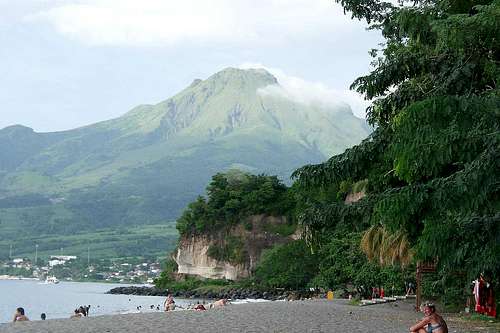
Pelée from the beach at Le Carbet
Martinique is a Caribbean island whose tourism comes mostly from France, with big jets flying in directly from Paris. North Americans, who have no direct access, tend to overlook it. It's heavily overbuilt in the south, but has a wild mountain center and some nice undeveloped coastline in the north. Exploration-minded visitors will find that Martinique has two great features: a wealth of high mountain and coastal trails that are easy to find and use, and a low hassle factor. The island is much better off economically than its neighbors, with people living at a standard comparable to Greece or Russia. This means you won't often be approached by vendors or guides; tourists are mostly left alone.
With a little ferreting on Kayak.com you can find decent air links between Martinique and Dominica, Antigua, St. Lucia (Castries only), and San Juan. There is also a fast ferry between Fort-de-France and several neighboring islands such as Saint Lucia. It's called L'Express des Iles, and, as far as I can tell, it's had a mostly broken reservations system for the last eight years; if you get frustrated, give up on their website and inquire with a Saint Lucia-based travel agent such as this one.
Martinique is quite a big island and driving is slow; if you want to climb Pelée, you'll do best to base yourself at Martinique's untouristy northern end, just beneath the mountain.
Routes Overview
Owing to the density of the vegetation, Pelée can only be climbed on established trails, of which there are three currently open:
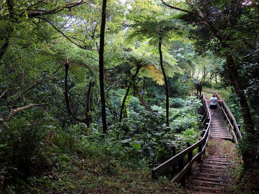
L'Aileron: The Aileron Route is a well-constructed and wonderfully varied trail coming up Pelée's east side. It starts on the Aileron itself, a fin that extends out from the volcano's flanks, then climbs beautifully vegetated slopes to the crater rim. After wandering along the rim, it drops into dripping fern forests in the caldera before crawling up the steep inner cone formed by the 1902 eruption.
La Grande Savane: This is a beeline trail coming up the sunnier west flank of the mountain. It lacks the variety of the Aileron route--skipping the caldera and some of the zones of vegetation--and it is uniformly steep. Its main attraction is that even after the summit area clouds up, as it does most days by mid-morning, this route tends to offer some pretty views on the way up.
North Face/Morne Macouba: This is the longest and least-used route, starting at one of a couple of trailheads far down the northern slopes. I have not done it, but it is described here. Trails from the different points of origin converge just before traversing Morne Macouba, a 4265-foot spur on the north side of the volcano. After crossing Macouba, the trail drops 200 feet to join the Aileron route at the Deuxième Refuge.
All routes pass one or more of the "refuges" on Mont Pelée. These are in ruins, useful only as landmarks.

Aileron Route
The Aileron Route is the standard route up Pelée. It gets a lot of traffic during the middle of the day, but it's pretty much deserted at dawn. And you should go at dawn.
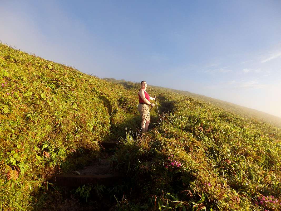
As a matter of fact, you should go before dawn. Here on the east side of Pelée, as well as on the summit cones, is the domain of the clouds--dark, dense, wet clouds, day after day after day. If you don't believe me, play the last 30 days of midday images from one of the Pelée webcams. This mountain is a cloud magnet, and the east side is the cloudiest side of a cloudy mountain. That said, if you leave the Aileron trailhead at 5 a.m., the odds are good that you'll beat the clouds, emerging at some point during your ascent into magical, clear views ... which might persist for an hour or two after dawn. Go for it. You can sleep in the afternoon, after you get down.
|
|


Where is this place you are going to go at oh-dark-thirty? Drive to the town of Le Morne-Rouge, which is about 15 minutes above/east of Saint-Pierre. Turn north on the N3 toward L'Ajoupa-Bouillon. Creep through the town center. After slightly less than two kilometers on the N3, you'll come to a traffic circle, where you go left on the D39 toward Pelée. Another two or three K brings you to the end of this road, where there is quite a large unpaved parking area on your left. Park here (free). You're at 824 meters/2703 feet.
Walk 100 yards up the steep track to the big radio mast above the parking area and bear left onto a fine, well-constructed trail. The entrance to the trail is not completely obvious by headlamp, but you're not likely to go far wrong. A steady uphill grade steepens to a mixture of stairs and light rock scrambling until, 1000 feet (300 meters) above the trailhead, you emerge on a ridgetop just south of the Aileron, the fin-like pinnacle projecting out from the main body of Pelée. Turn right and continue on gentle grades across the Aileron, where a final set of switchbacks take you up to the crater rim.
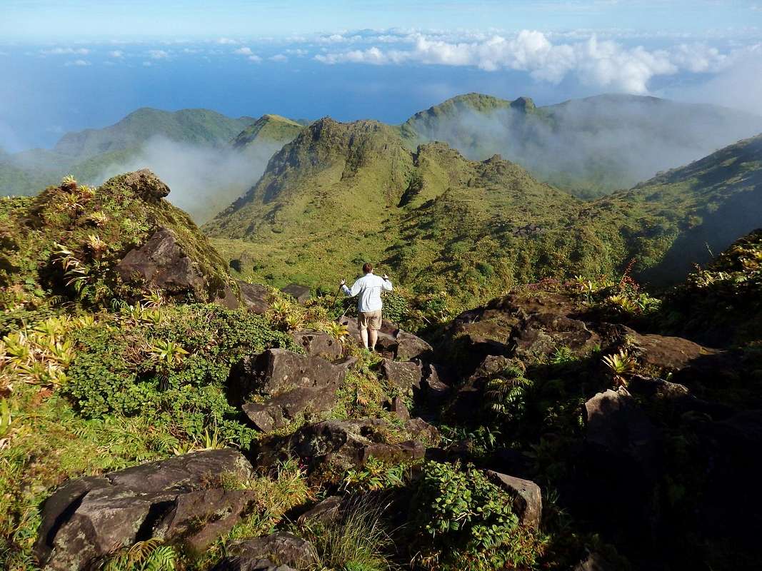
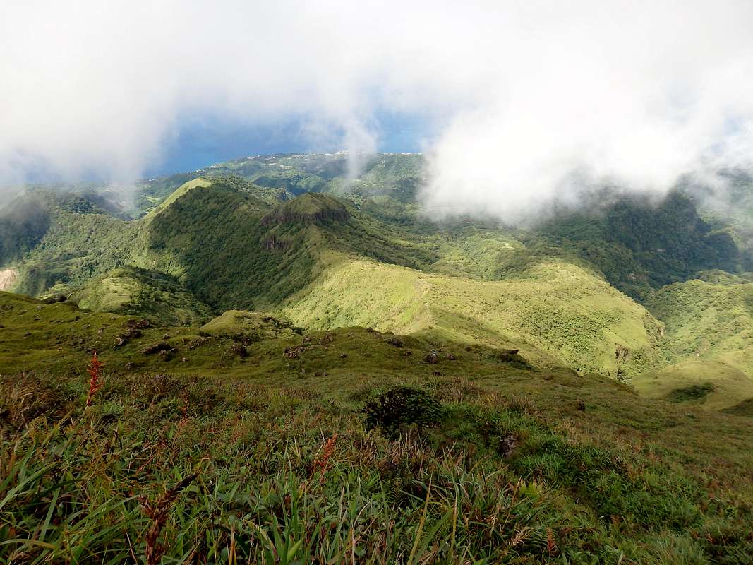
At 4000 feet, the crater rim is a terrific destination in itself, with top-of-the-world eastward views and good vantage points into the rugged, lushly vegetated caldera. To continue to the summit cones, however, you'll want to turn right along the rim and walk the better part of a kilometer till you see a sign for Le Chinois and the Cônes de 1902/1929. Descend into the fern forests of the caldera here.
Once past the bottom of the caldera, the character of this trail changes. It is so, so wet here--annual precipitation tops 300 inches--that hiking on the inner cones is like being in a slimy tidewater boulder-field at low tide. The higher you go, the slipperier it gets, until the slickness of the rocks is almost beyond belief. There's no exposure and you're not going to fall to your death, but the going can be really, really slow and treacherous.
About half an hour of this brings you to your first real summit, the 4476-foot Cône de 1902, which opens up a vast northward panorama. To continue to Pelée's highest top, you'll traverse this and pick your way down to the tiny, ruined Troisième Refuge, turn left, and spend another 30-45 minutes going up and down on yet slipperier rocks to Le Chinois, the real top of Pelée. Watch for the yellow X's, which clue you in that certain trail branches are NOT to be followed on this jumbled summit mass. Le Chinois is totally worth the extra effort, opening up new views over Saint-Pierre from a beautiful, craggy peak among gorgeous flowering plants.
Even though there isn't much mileage and the net vertical rise is only 2000 feet, getting from the trailhead to Le Chinois will take 2-4 hours one way. With the ups and downs along the route, the gross vertical ascent is about 2500 feet outbound, and 3000 feet/1000 meters for a round-trip.
Those with plenty of time to enjoy the wonders of Pelée may want to descend westward from the Troisième Refuge, going down the steep, uppermost 500 feet of the Grande Savane Route. You can then circle back to the Aileron along the caldera rim. This is fun to do, but it's not fast and it adds about an hour to your round-trip time.
|
|

Grande Savane Route
A route with a tiny fraction of the usage of the Aileron Trail is the ascent of Pelée's west flank via "La Grande Savane" (the great savanna). This is a beeline route that doesn't have the scenic variation or interest of the Aileron, but it's not a bad choice for people who are getting a late start. This is because the west side is drier and less apt to be socked in by cloud, meaning you're likely to get at least some views on your way up, even if you don't get any on the summit.
The crux of the Grande Savane route is getting there. Drive north from Saint-Pierre on the D10 toward the village of Le Prêcheur. On the south end of that village, there is a signposted right turnoff for Pelée. Go straight up this, with no turns, till it dead-ends at trailhead parking, where there is space for a few vehicles. The 2000-foot climb up this single-track, overgrown, potholed road is extremely steep for ordinary cars. I've done it (barely) in a rental Clio, but I left quite a bit of burned rubber and maybe a few bits of the undercarriage along the way.
|
|
The Grande Savane trailhead is at about 670 meters, leaving you 730 to ascend to the top, but since it lacks the ups and downs of the Aileron route, it may not be much more effort overall compared with that trail. The first 70 meters/200 vertical feet are in a pretty fern forest; after that, you're out in the wide open "savane," and this can be a blazing hot climb (don't forget the sunscreen). The path goes straight up through the tall grass, with an ascent grade of 25-35 percent. At 1155 meters, where it intersects the caldera trail near an automated weather station, you'll need to pay attention; the continuation of the trail eastward and upward toward the Troisième Refuge is a little hard to spot among the rocks and vegetation. Just remember that this path is direct--you need to look straight up.
The Grande Savane trail ends at the ruined Troisième Refuge, just below the Cône de 1902. Proceed from there as discussed in the Aileron Trail section.
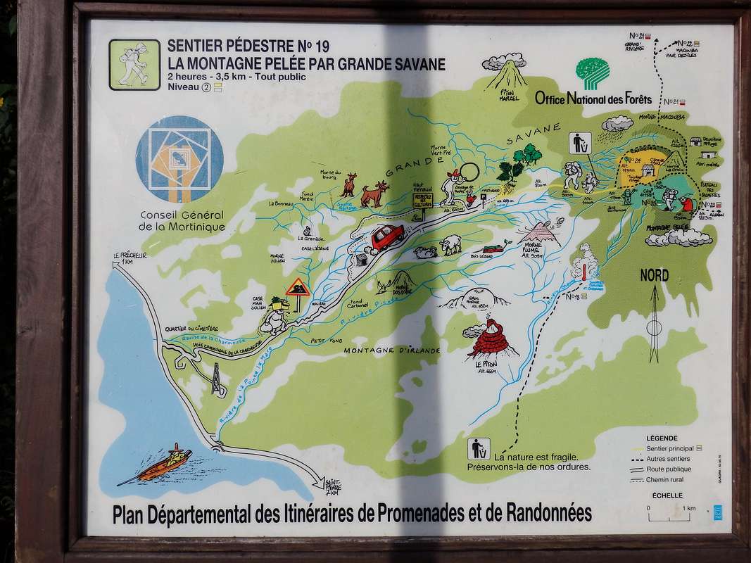
For a map of the route, click here.
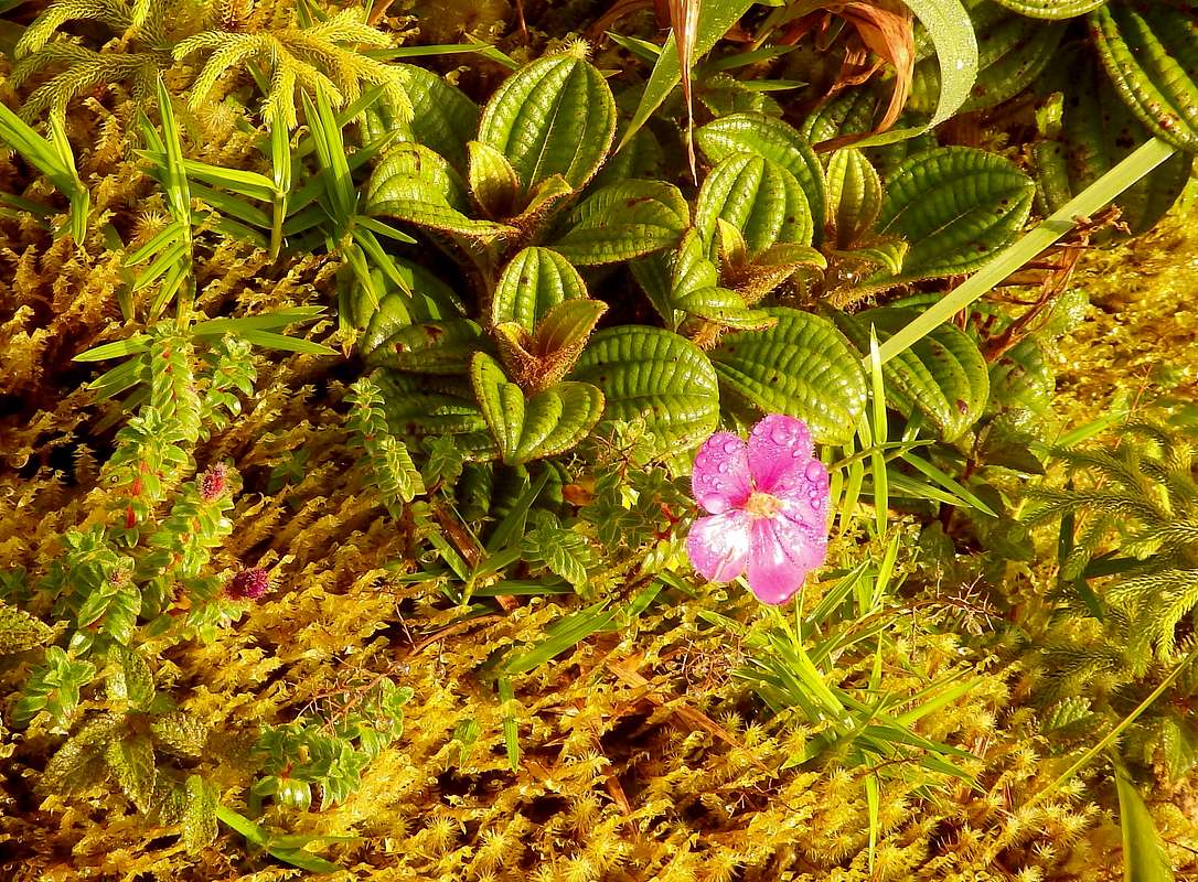
Flora
|
|

History
At the turn of the twentieth century, Saint-Pierre on Martinique had a population of 30,000 and, with its fine buildings and high culture, was known as "the Paris of the Caribbean." In the spring of 1902, the stratovolcano above the town showed increasing signs of restlessness. A few people fled, but on May 5 a huge lahar of scalding water and debris swept down the mountain into the sea, killing 25 people and frightening villagers to take refuge in the city, swelling the population once again. Three days later, on May 8, 1902, the mountainside collapsed above the city. A nuée ardente (a "burning cloud," or pyroclastic flow) crossed the intervening four miles at more than 100 miles per hour, hitting Saint-Pierre with such force that walls three feet thick were smashed. Temperatures inside the cloud have been estimated at 700 degrees Celsius.
One person in the city center survived: Louis-Auguste Cyparis, who had had the good fortune to be jailed for brawling the night before. His cell was a converted magazine, built to be bomb-proof and practically airless. Though badly burned, Cyparis lived through the eruption and later toured with Barnum & Bailey as a kind of freak.
The popular version of this tragedy has Cyparis as the sole survivor of the eruption, but in fact there were many survivors, a lot of them horribly burned, from the countryside around Saint-Pierre in areas not directly hit by the cloud. Relief workers flooded to their aid, only to die by the hundreds in a second eruption twelve days later. A third nuée ardente wiped out Morne Rouge in August.
Saint-Pierre has never recovered. Its current population, who live among the ruins of the old city, number fewer than 5000.
Interestingly, the May 8 eruption was separated by just one day from a pyroclastic eruption of the Soufrière volcano on St. Vincent, two islands down the Windward chain. That event was similarly catastrophic, and although St. Vincent lacked the population of Martinique, the eruption killed enough people to be ranked the ninth most deadly in the twentieth century.

(Photo: Tempest Anderson, 1902, public domain)
Maps
|
|


Links
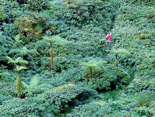
Thrashing through the saturated fern forest in the bottom of the caldera, on the way to the Cone of 1902.
Account of the great eruption
Another account with historic photos
Monitoring site (reports any current volcanic/seismic activity)
Pyroclastic flows
Parc Naturel Régional de la Martinique
Saint-Pierre Tourist Office
Decent, affordable cottage in Saint-Pierre, good base for Pelée