
|
|
Mountain/Rock |
|---|---|
|
|
1.85657°S / 78.48377°W |
|
|
Hiking |
|
|
Spring, Summer, Fall, Winter |
|
|
14400 ft / 4389 m |
|
|
Overview
La Torre is a fun and easy acclimatization hike (around 4 hours round trip starting around 10,200 ft/3169 m) with excellent views of El Altar, Parque Nacional Sangay, and erupting Sangay volcano on a clear day. It sits on the edge of Parque Nacional Sangay hulking above the community of Alao Llactapamba.
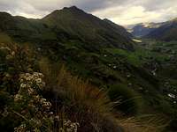 La Torre seen from the west on the long trail to Alao Maguasu.
Weather is famously terrible in this region, often being cold, rainy, and cloudy (and sometimes snowy). The best plan to get to the top of La Torre and have a decent view is to start very early - even before dawn if possible. Try and get to the top before noon.
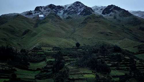 La Torre with a coat of snow.
Getting There
Take a red and white ´Pungala´ bus in the La Dolorosa station of Riobamba. Cost is currently $1.25 one way between Riobamba and Alao. Buses begin leaving around 11:45 a.m. and from then on leave semi-hourly, sometimes only when full. It takes around an hour and a half or two hours to get to Alao, which is pretty much at the end of the road. You´ll pass through the communities of Licto and Pungala. If the bus crosses the bridge over Rio Alao, you are heading to Alao San Antonio. You´ll want to begin your hike on the other side, at Alao Llactapamba. Until I post GPS coordinates, you might want to ask around how to get to the community Alao Maguasu because being an agricultural community, they have a lot of trails. The trail you want takes you up through eucalyptus forest and around La Loma, a minor hill to La Torre. Keep winding up the very well-defined trail until you reach the saddle. If you were to keep heading north (down) you´d be going to the remote community Alao Maguasu. Head right (east) up the spine of La Torre. The trail begins distinctly but eventually fades. All you need to do though is follow the spine more or less up to the summit. Be on the lookout for toros bravos (fighting bulls) and give them plenty of space and respect.
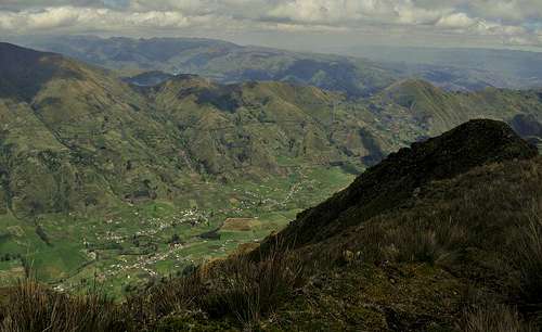 Looking west from La Torre
Buses leave for Riobamba from Alao starting at 5 a.m. and continue for about every hour until 10 a.m., then begin again at 12:30 p.m. until the afternoon. Best to ask when you arrive.
Red Tape
None. Please just be respectful of the people and their land.
Camping
There are no restrictions on camping but be extremely wary of paramo burns. Large sections of grassland are burned almost daily to clear land or to get ´fresh´ grass to grow quickly for cows. This happens both during the day and at night.
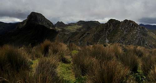 Paramo of Parque Nacional Sangay, looking east from La Torre summit
The community is in the process of developing cabins for tourists near the Centro Interpretivo. Until then, if you arrive during the day during the week, you can check in with the guardhouse (Oficina Technica de Parque Nacional Sangay), about 15 minutes down the road from where the bus lets you off. They may be able to set you up with a place to stay but don´t rely on this.
External Links
Parque Nacional Sangay homepage General info about the park
visentin - Oct 26, 2011 3:10 pm - Voted 10/10
coincidence ? :)http://www.summitpost.org/la-tour-la-torre/755869
chugach mtn boy - Oct 27, 2011 11:51 am - Voted 10/10
Bad LinksThe links at the end are bad because they have an extra "A" character in them. The first one should be http://www.sangay.eu/parque-de-sangay.php The second one should be http://www.sangay.org/parquenacsangay.html
Socorro - Oct 29, 2011 12:37 pm - Hasn't voted
DoneThanks! And yes, coincidence! Lots of towers out there :D