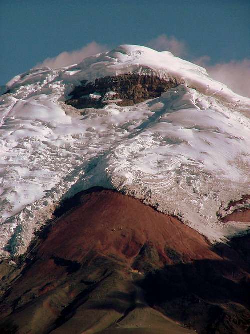
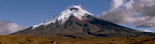
As one of the highest active volcanoes in the world, with a nearly perfect conical shape, Cotopaxi attracts more visitors than any other volcanoes in Ecuador. This is the classic volcano people imagine when they think of volcanoes.
Cotopaxi is the second highest mountain in Ecuador (5,897 m / 19,347 ft.) and the most popular high altitude climb in the country because of the relative simplicity involved in the climb. But although, climbing Cotopaxi is considered not difficult, it is considered a technical climb too, because of the technical climbing gear necessary for the ascent, such as: crampons, ice axe and crevasse rescue gear. It is also known as the world’s third highest active volcano after volcan Ojos Del Salado (6,893 m / 22,615 ft.) and Tupungato (6,550 m / 21,490 ft.) in the Argentine/Chilean border.
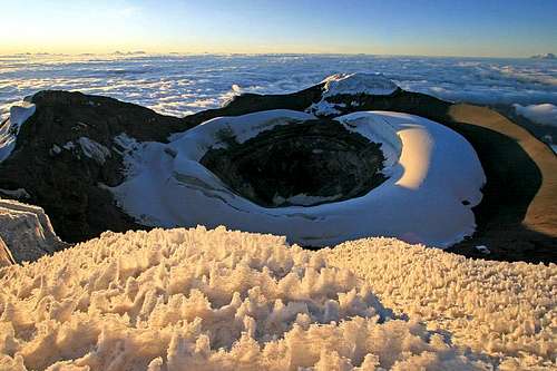
Cotopaxi crater as seen from the north summit. marauders
Its volcanic activity can be easily perceived by those who have reached its summit or the proximity of its external northern crater walls known as Yanasacha (black rock in kechwa language). The summit or highest point it’s actually the northern rim of the crater, which is rounded and measures approximately 480 meters wide. The smell of sulfur and the presence of fumaroles are evident from up there. A circuit of its inner crater rim can be done in about one and a half hours depending on snow conditions. Several visits into the crater have been undertaken, most of them by Ecuadorian parties. Please note that because of the high altitudes involved in climbing Cotopaxi, being acclimatized is highly advised in order to enjoy your climb and to avoid any kind of AMS symptoms, very common among visitors. Other higher active volcanoes than Cotopaxi
There are some other active volcanoes higher than Cotopaxi. Sabancaya (Peru), for example, is very active and was last surveyed at 5976 meters, but with all the recent eruptions, it is thought to be over 6000 meters. Either way, it is higher than Cotopaxi. Guallatiri is at 6063 meters and is very active as well. It may be the highest volcano that has actually be seen to erupt lava in recent times. It is debatable whether or not Ojos del Salado is an active volcano. It is a volcano for sure and has some fumarole activity and steam vents. Some consider it to be active, while others do not. Part of Tupugato massif is active, but it's not the main summit, but a subsidiary summit known as Tupungatito which is active. Tupungatito is around 5900 meters (some sources say 6000 meters).
** Thanks Scott for the info.
A bit of history
These are few of the most important events recorded during Cotopaxi’s volcanic activity:
1742. Cotopaxi erupted three times, destroying Latacunga and killing hundreds of people. The volcanic activity continues for the following 4 years. 1768. Latacunga is destroyed again by another eruption killing many lives once more. 1853. Cotopaxi enters in activity once again. The volcanic activity lasted almost a decade. 1877. Cotopaxi erupts again wiping out Latacunga and surroundings. 1904. Cotopaxi erupts. (Small eruption). Other important events: 1872. Cotopaxi is climbed for first time by Wilhelm Reiss (GER) and Angel Escobar (COL). 1972. First descent into the crater by a Polish-Czech Expedition. 1996. An avalanche partially buried the refuge killing 13 people.
Getting There
Cotopaxi National Park is located approx. 55km south of the capital city of Quito. This is one of the reasons why Cotopaxi can be seen unmistakably from the north and center of Quito in a clear day or as your plane overflies the city before landing on its airport.
On the way to Cotopaxi. Control Norte, El Pedregal. andreeacorodeanu
From Quito, take the southbound trolleybus (USD. 0.25) or a taxi (USD. 5,00 – 6,00 from downtown) to the brand new Main Bus Station (Terminal de buses Quitumbe). Once there you can take any of the buses heading south to the city of Machachi or Latacunga, depending on the entrance you’d like to take for access into the park. There are two ways to enter into the park. One is by the North Entrance or control norte and the other by the South Entrance or control sur.
Control Norte or El Pedregal:
From Quito (Terminal Quitumbe), take Transportes Mejia (green buses) or Transportes Carlos Brito (purple buses). Both can be found at the eastern side of the terminal, right outside the food court. It’ll take you a bit less than an hour to get to Machachi (the final stop) for only USD. 0.75. Once in Machachi, make sure you get off the bus at the main square or at the market “Mercado Amazonas”, where you can hire a pickup truck for USD. 35,00 one way up to the parking lot (one and a half hours approx.). You can also fix arrangements for your return trip. Machachi is a good option if you have to stock up on last minute supplies. There are many small stores (tiendas), bakeries (panaderias), internet access, restaurants all over town. You can even find a big market (Almacenes Tia) where you can get some provisions for your trip. Optional transportation: There’s a bus company “Transportes Machachenas” a block away (north) from the main square. These buses leave every 45 minutes – 1 hour towards El Pedregal (USD. 0.50), which is a village located half way to the north entrance. From there you’ll need to hike to the north entrance for about 1 hour and about 5 hours to the parking lot. There’s not much traffic going that way, therefore catching a ride would be difficult. This is a good option for saving a few bucks, not for saving energy for the climb, though.
Control Sur or El Chaspi:
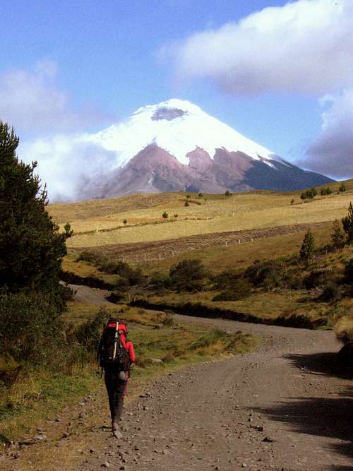
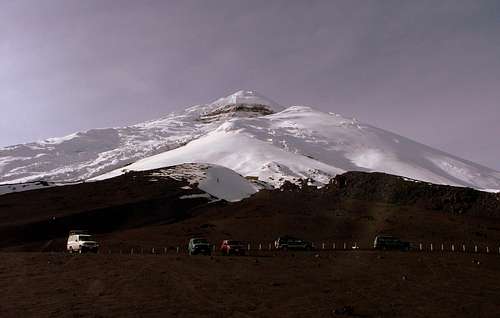
Cotopaxi as seen from the parking lot.
From Quito (Terminal Quitumbe) take any of the southbound buses along the Pan American Highway to Latacunga located 30 minutes after the south entrance junction. There are at least three bus companies providing their transportation services to Latacunga. Don’t forget to show your boarding pass to the driver to make sure you’re on the right bus. It’ll take you about 1:15 hours to get to Cotopaxi south entrance. Let the driver or his helper know you need to get off there. There is a pickup truck company offering rides to the parking lot for USD. 35,00 one way at the entrance. You can bargain the price and also arrange to get picked up the next day after the climb. It takes an extra one and a half hour to get to the parking lot from the south entrance. The differences between entering by the north or south control are road conditions and scenery. The road to the north control is not as well maintained as the south one is, but it’s more scenic. Another option is to stay in Quito, and typically you can hire 4WD transportation at any of the local agencies to take you straight to the entrance of the National Park and to the parking lot. This is much easier than trying to take a bus and etc. Rates are between USD. 80,00 – USD. 100,00 a day. At this point, from the parking lot (4,600 m / 15,088 ft.), you do have to hike up a ways. Climbers normally arrange to get picked up the following day around 10 am – 1 pm.
Red Tape
Starting Nov.12 2012 nobody is allowed to climb any glaciated mountain in Ecuador without hiring an accredited mountain guide. This restriction was issued by Ecuadorian Government after the last fatal accidents that happened in 2012 in Illiniza Sur and Norte. There are not fees to enter Cotopaxi Park. Refuge fee is: USD. 32,00 for foreigners, Ecuadorians and residents. Please note that Refuge fees increased in March 6th, 2015. Fares: USD. 32.00 for foreigners and residents. By paying this fee you'll be entitled to have breakfast and lunch prepared for the refuge's staff, but nobody will be allowed to enter into the kitchen to prepare meals, or boil water. Changes are being put into consideration by the new management, few of them are still uncertain.
For more information about the refuge and fares please click here.
Cotopaxi North Face. Panoramic View.
When To Climb
Cotopaxi is blessed with the highest number of clear days per year in the Ecuadorian Andes. Climbs can be attempted year round. June and July are the driest months, but extremely high winds blowing for days on end are not uncommon. December and January are almost as dry and much less windy.
Camping and Refugio Info
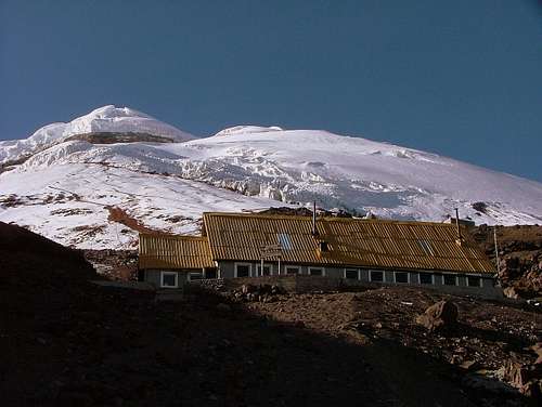
The refugio Jose F. Rivas is located at 4,800 meters (15,744 ft.) and was built in 1971, extended in 1977 and remodeled in 2009. It is about a 45 minute-hike from the parking area and the cost is USD. 32,00 per night and includes breakfast and lunch prepared for the refuge's staff. This two story building is very nice in comparison to the Mexico huts. You will find 50 bunks, water, electricity, a kitchen, bucket flush-toilets, a fireplace and lockers to store your extra gear while you climb. Most parties do their summit bid directly from the hut.
Jose F. Rivas Refuge. (4,800 m / 15,744 ft.)
For the ones who search for tranquility, you can camp on a nice plateau a 50 meters right from the hut. The view is stunning and you are separate from the touristic crowd that passes by the hut every day. Keep in mind, if you choose to tent it and not pay the refugio, you cannot use ANY of their facilities. The Inn Keepers sees to that. No H2O, no restrooms etc.
If you opt to camp, I recommend heading over the ridge (right). It obviously requires more gear, stove, food, tent, etc, but is worth it as it is much quieter and the views are stunning! (as long as the weather is good, of course). For more information about Jose Rivas refuge and other pleasant mountain lodges within the park, click here.
Routes
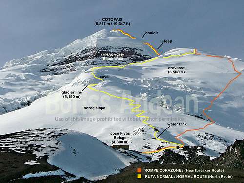
NORMAL ROUTE (Grade II/PD) This route is not currently used due to ice fall danger. It starts on the scree slope located right above the refuge (North Face). It runs by a series of switchbacks that end up at the glacier line, clearly seen from the refuge. It is scenic and not boring at all.
It continues all the way up to the lower flat section below Yanasacha, after traversing through a labyrinth of crevasses and tall seracs. Few deep and huge crevasses should be negotiated. In fact, you may need to cross a deep crevasse at 5,300 m (a long ladder has been placed here), 5,400 m and 5,500 m in order to reach the mid section of the glacier and to join with the old "Rompe Corazones" route. Some huge isolated seracs can be seeing in this section threatening to fall over the passing climbers. One already killed a Canadian climber in June 2013. Extreme caution is advise here!. After a few long traverses in west direction you'll reach Yanasacha's right side plateau. The steep slope at the right side of Yanasacha must be climbed in order to set yourself right at the bottom of an easy steep gully. Climb it up to its upper part, then you'll be set again at the base of another easy steep gully (hand-made) located right below the summit. Ecuadorian guides shoveled a canal up to the lower part of the summit, in order to avoid traversing through the expossed pass above Yanasacha. You'll be topping out after making a long easy traverse south towards the summit. ROMPE CORAZONES (HEART BREAKER). (Grade II/PD). This variant of the normal route was open again in July 2013 after several years of been closed and due to the fatal accident and ice fall danger registered on the normal route in June 2013. Its name says it all since it is hard to find a good resting spot for the first two or three hours on its steep terrain. It actually is a long and tiresome route. It starts at the right side of the refuge and continues diagonally up for about two and a half hours on steep terrain. This route joins the actual normal route after crossing a huge deep crevasse at 5,500 m which at the moment can be negotiated. This route was opened in 2000 and used till 2009 then it re-opened again in July 2013. SOUTHWEST ROUTE (Grade II/PD) This was the very first route climbed back in 1872 by Wilhelm Reiss (GER) and Angel Escobar (COL). This route started to register fewer ascents since Jose Rivas refuge was constructed on the actual normal route (North face).
Mountain Conditions
As I pointed out before, the mountain is not difficult but does require crampons, ice axe and rope. The mountain is well crevassed, all the way up to the summit. For the most part, the crevasses are spectacularly large and open thus easy to avoid but beware of the multiple snow bridges...travel by night and come back early as the snow gets very slushy. Some climbing tips:
Snowstorm on Cotopaxi.
Crevasse crossing.
The route is well beaten in but here there is some advice that could help your climb to be more enjoyable and successful: Get up at midnight, be off at 1 am and you can summit in 7-9 hours. You’ll be climbing up for the first 1 – 2 hours on steep scree (sometimes covered by snow) on switchbacks. Be patient and don’t run up. Saving energy during the first hours will help you considerably once you reach the glacier, where you may want to rope up. Some aluminum ladders as well as climbing protection (fixed lines) can be set up on exposed sections (depending on climbing season). Feel free to clip in with your carabineer if you don’t feel confident enough to negotiate them without their aid. Better being safe than sorry.
Watch out for the crevasse and the hanging seracs at 5,400 m. They already killed a climber (June. 2013) You hit the crux, or steepest section, just above the Yanasacha or the black band. Keep your head down and persevere, the route winds around just a bit and continues up by a couple easy gullies, then you hit, easy type ridge. Here the steepness eases to the summit after negotiating the last couple deep crevasses. Spend a day or two is better (if you have the time), acclimatizing and your climb will be smoother.
Guidebooks
Ecuador: Climbing and Hiking Guide, 6th Edition, by Rob Rachowiecki and Mark Thurber, (2008) Ecuador : A Climbing Guide by Yossi Brain. (September 2000) Maps: Maps 1:50,00000 Sincholagua and Cotopaxi are available at IGM (Instituto Geografico Militar) in Quito, sector El Dorado. They can be purchased at some of the main bookstores in La Mariscal area in Quito.
As of November 2021, camping is no longer allowed outside of the refugio. We were told by our guide (Edgar of Lonely Summits) that since COVID, the park has become more strict around camping and climbers are only allowed to stay in the refugio. We saw no campers while staying there. Bummer since we brought all of our camping gear!
Children refers to the set of objects that logically fall under a given object. For example, the
Aconcagua mountain page is a child of the 'Aconcagua Group' and the 'Seven Summits.' The
Aconcagua mountain itself has many routes, photos, and trip reports as children.
Parents refers to a larger category under which an object falls. For example, theAconcagua mountain page has the 'Aconcagua Group' and the 'Seven Summits' asparents and is a parent itself to many routes, photos, and Trip Reports.

 308297 Hits
 99.69% Score
 130 Votes


climbvr - Dec 16, 2018 2:49 pm - Hasn't voted
Normal Route in UseClimbed Cotopaxi this morning via the normal route. Our guide told us it's the only one in use and has been for a fair while!
Dra125 - Nov 30, 2021 12:41 pm - Hasn't voted
Camping No Longer AllowedAs of November 2021, camping is no longer allowed outside of the refugio. We were told by our guide (Edgar of Lonely Summits) that since COVID, the park has become more strict around camping and climbers are only allowed to stay in the refugio. We saw no campers while staying there. Bummer since we brought all of our camping gear!