
|
|
Mountain/Rock |
|---|---|
|
|
46.94800°N / 115.6189°W |
|
|
Hiking, Mixed, Scrambling |
|
|
Summer, Fall |
|
|
6661 ft / 2030 m |
|
|
Overview
 Larkins Peak from Crag Peak
 Larkins Lake
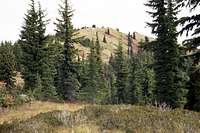 South Side
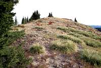 The Summit
Larkins Peak anchors the west end of the popular group of mountains known as the Mallard Larkins Pioneer Area. The main axis of this group forms the divide between the North Fork Clearwater River and the Little North Fork Clearwater basins and is also the boundary between the Clearwater National Forest on the south and the Idaho Panhandle National Forest on the north. Though these mountains are not terribly high in elevation, they have dramatic vertical lift from the deep canyons of the Clearwater Basin. From the North Fork Clearwater, much of the area rises more than a mile in a short horizontal distance. Most of the steep south slopes rise more than a mile above the North Fork Clearwater River before abruptly falling off to the sheer glacially carved faces north facing cirques.
Larkins Peak is the most easily accessible peak in the group, but its summit is generally passed as hikers continue on to any of the many lakes that are mostly found on the north side of the divide. A hike to the summit is a simple detour off the main trail and is easily done up the south summit ridge. The north side is formed of broken cliffs and slopes which provide a dramatic 1,100 ft. back drop to Larkins Lake. The summit is open with a mosaic of mountain hemlock and subalpine fir with grasses, bear grass, whortle berry, heather and other vegetation found just below the tree line. There is a little debris on the summit indicating the presence of a historic lookout or perhaps an observation station of some sort.
The area has a pronounced orographic effect, which results in extremely deep snows at the higher elevations and heavy rains in the canyons. As a result, snow generally makes portions of the trail impassable well into July. Also the lower elevations are well known to support several plant species with ranges disjunct from the Pacific Coast. There are a few high elevation plants that also illustrate this phenomenon.
The area is very popular and in the summer receives relatively heavy use. In the fall hunters will take over the parking areas and be found throughout the slopes. Don’t ever expect isolation and in the fall be sure to wear bright orange and if possible travel in groups. The area is also well known for mountain goats, which can frequently be seen on the rugged north slopes.
Getting There
 East Slope
 Goat Ridge High Point
 Goat Ridge
If coming from Lewiston, follow Highway 12 to the town of Orofino and turn east across the bridge over the Clearwater River into downtown. Follow the main road through town (Michigan Street) and climb the grade east of town. This road is paved, but some places have a rough surface and some bad corners. Keep on this road for 26.5 miles to where it forms a T at the Bald Mountain Ski Area turn off. Take a left on the main road (Highway 11) and continue 7.3 miles to the next T at the small town of Headquarters. Headquarters is a small group of buildings that is an administrative center for the Potlatch Corporation; there are no services. Turn left at Headquarters (forest road 247) and continue for 24 miles to the bridge of the North Fork Clearwater River. Immediately turn left off the pavement onto road 700. After about a mile this road leaves the river and turns north up the Isabella drainage. After about two more miles the road turns to the left, leaving Isabella Creek. Continue up the 700 road, climbing for ten more miles to the trailhead where the road crosses Smith Ridge.
If coming from the south, take Highway 12 to Kamiah and continue approximately 15 miles to Highway 11, which crosses the Clearwater River to the right at Greer. Then climb the steep 8 mile Greer Grade and continue on about 12 miles to Weippe. Here turn left and follow the signs to Pierce. Continue through Pierce about 5 miles to the Bald Mountain Ski Area turn off and then follow directions above. One can also skip the Greer Grade and continue to Orofino on Highway 12 and follow the directions above.
From the trailhead, trail 240 heads east for about two miles then turns north with the main ridge for about four more miles to Larkins Peak. An unofficial trail cuts across the southwest aspect of the summit and gives the impression that it may go to the top, but it does not. It probably peters out to the west of the summit or perhaps reaches some lesser known lakes in that direction. Most maps show a trail continuing up the south ridge, but this has faded away, but that route is still the easiest way to the summit. The 240 trail is indicated on maps to follow the ridgeline more or less the entire way. It has been rerouted in recent years to a more continuous and gentle grade mostly on the north side of the ridge for the first two miles and the west side in the vicinity the Goat Ridge high point. The trail is well maintained and the trailhead obvious so there is no need to be concerned with differences between the map and the ground.
Larkins Peak can also be reached by trails 95 and 96 that are accessed near the end of the Isabella Creek road, 705. These longer routes climb from much lower elevations and require much more time.
Red Tape
None.Camping
 The western Mallard Larkins
People wanting to car camp and have a long day hike can use the very scenic Aquarius Campground, which is immediately upriver from the bridge crossing the North Fork Clearwater River. This campground is situated in old growth western red cedar against the rapids of the North Fork. There are only a few campsites so arrive early, especially if visiting the area on a weekend. There are some nice dispersed camping areas several miles up the river, some with nice sandy beaches. These are often full as well. To the south of the river there are many dispersed campsites off the paved road along Beaver Creek that would provide good car camping. But most of these are filled up with loggers who work on the Potlatch timber lands in the area. Backpackers will find several remote camping possibilities at the numerous lakes in the Mallard Larkins Pioneer Area. Larkins Lake is the closest to Larkins Peak being found at the northeast foot of the mountain.
When To Climb
 End of the day
The upper elevations of these mountains get a lot of snow and hiking to the summits before mid-July may be difficult some years. Most precipitation on the lower elevations is in the form of rain, thus the interesting montane rainforests on the lower slopes can easily be explored in winter. Of course this is depending on the conditions of road 247 over Beaver Pass and down into into the North Fork Clearwater canyon. Generally this road is not open most of the winter, and there is no other way in.
Mountain Conditions and Information
 North to Snow Peak
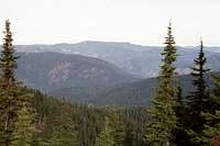 Monumental Buttes
Go to the mountain prepared for variable conditions. With over a mile of vertical lift, mountain temperatures can vary dramatically.
Contact the North Fork Ranger District of the Clearwater National Forest for information and current conditions.
North Fork Ranger District
12730B Highway 12
Orofino, ID 83544
(208) 476-4541
Canyon Work Center (summer only)
(208) 476-8306
NOAA Forecast
tva - Jul 17, 2007 11:41 pm - Voted 9/10
typo"The summit is open with a mosaic of mountain hemlock and subalpine fire with grasses..." should of course be "subalpine fir".
mrh - Jul 18, 2007 8:18 pm - Hasn't voted
Re: typoThanks, I'll fix it.