
|
|
Area/Range |
|---|---|
|
|
46.87900°N / 115.5508°W |
|
|
Hiking, Trad Climbing, Bouldering, Mixed, Scrambling |
|
|
Summer, Fall |
|
|
7077 ft / 2157 m |
|
|
Overview

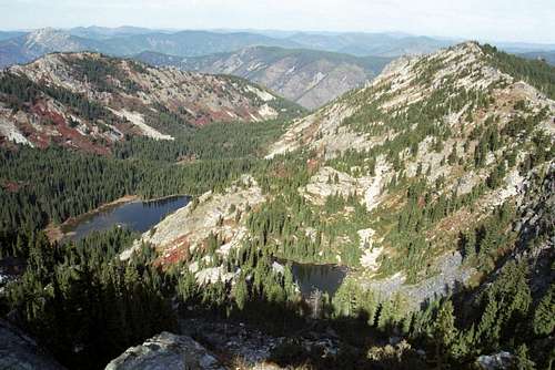
Mallard-Larkins group from The Nub

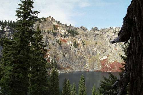
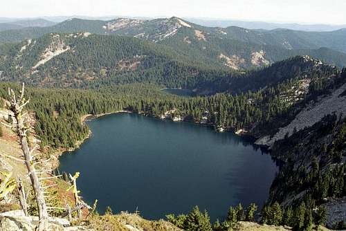
Crag Lake and Pt. 6,830
Introduction
The Mallard-Larkins Pioneer Area is a primitive area straddling the divide between the North Fork Clearwater River and the Little North Fork Clearwater River basins about sixty miles northeast of Orofino in north central Idaho. The 30,000 acre area is the centerpiece of a larger 260,000 acre roadless area that has been under consideration for wilderness designation since the 1960s. The Forest Service has since recommended about 150,000 acres as designated wilderness, but it has yet to happen and probably never will due to political factors. However, much of the area is managed as wilderness despite lacking the formal designation and offers many interesting and unique features.
The designated Pioneer Area is roughly divided in a western portion that includes the east-west running divide and the namesake peaks and the eastern portion that is actually to the southeast, centered on the Black Buttes and adjacent mountains. The latter are slightly higher, rise more abruptly from the main river canyon and get fewer visitors, though the western area generally has the more glaciated terrain that supports more lakes. The rise from the main North Fork Canyon is generally over a 5,000 feet in most areas on steep, but straight south slopes. The north aspects are where most the glacial cirques and lakes are found below spectacular cliff faces and outcrops. Terrain is present for casual hikers as well as the technical climber, however little of the latter activity occurs.

NW face of Crag Peak
The area is used heavily for recreation and hunting that utilizes the steep mountain slopes, jagged ridges and 38 subalpine lakes; 21 of which are within the designated Pioneer Area. Biological diversity is very high due to abrupt elevation gains that range from low elevation disjunct coastal rainforest communities to the subalpine. In the high country, extensive lodgepole pine and mountain hemlock forests mingle with subalpine meadows, high mountain lakes, and craggy peaks. Impressive pockets of old growth western red cedar, grand fir and western white pine, some quite massive, remain in the lower elevations. The Heritage Cedar Grove has trees up to 12 feet in diameter and over 150 feet tall that are several hundred years old. Some likely exceed 1,000 years. These forest provide ample shade over lush fern communities dominated by sword fern, maidenhair fern, lady fern and many others.
Peak List

East face of Isabella Point

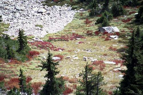
Point 6,617 and Point 6,830
Due to the relatively small area of this group, the peak list is not long. The list is limited to peaks over 6,300 feet with greater than 300 feet of prominence so several high ridge points are excluded that would be fun and challenging for scramblers or climbers. If the prominence were lowered to 200 or more feet the list would include 8 additional points. Particularly noteworthy of these would be the ridges on the west and east side of Crag Lake, Goat Ridge, West Sister on the flank of Black Mountain, Avalanche Ridge and Isabella point, especially the rugged southeast aspect. There are probably many other worthwhile slopes including most the canyon headwalls and cirques above the lakes.
| Peak | Elevation | Prominence | Lat./long. |
| Black Mountain | 7,077 | 2,217 | 46.8790N 115.5508W |
| East Sister | 7,043 | 863 | 46.8873N 115.5276W |
| The Nub | 6,924 | 1,063 | 46.8724N 115.4902 |
| Crag Peak | 6,879 | 1,208 | 45.522N 115.669W |
| Heart Peak | 6,870 | 329 | 46.9362N 115.5842W |
| Mallard Peak | 6,870 | 890 | 46.9381N 115.5239W |
| Larkins Peak | 6,661 | 521 | 46.9480N 115.6183W |
| Surveyors Peak* | 6,517 | 1,217 | 46.987N 115.480W |
| Collins Peak | 6,383 | 643 | 46.959N 115.484W |
| Northbound/Martin divide | 6,347 | 607 | 46.947N 115.551W |
 Crag Peak
*Technically, Surveyors Peak is not within the boundary area of the Mallard-Larkins Pioneer Area. However, it is only one mile from the border and is a significant peak in the area and all the northern access points are found on its slopes or ridge, thus it is included in this artificial group.
Other Area Features
Dworshak Dam and Reservoir

Dworshak Dam

In the late 1960s and early 70s, one of the largest dams in the U.S. was built across the North Fork Clearwater River near its mouth. The huge Dworshak Dam is a giant concrete hydroelectric gravity structure 717 feet tall and 3,287 feet wide. The dam is the highest straight-axis concrete dam in the Western Hemisphere and the 22nd highest dam in the world. Only two other dams in the United States exceed it in height. While the dam provides electricity and eliminated the often disastrous floods in the lower Clearwater Basin, it was an ecological catastrophe in other ways. The 53 mile long Dworshak Reservoir flooded a warm, low elevation primitive canyon that was a vital wintering ground for the Clearwater elk herd. Such habitat loss is one of the reasons the herd has declined in recent years. Also the dam eliminated runs of anadromous fish such as steelhead and fall Chinook salmon. Much of the unique, disjunct coastal rainforests of north central Idaho was drowned as well.
The Army Corps of Engineers constructed Dworshak National Fish Hatchery to mitigate for fishery losses from the construction and operation of Dworshak Dam. Fish mitigation facilities include a fish hatchery with a design capacity for 420,000 pounds of steelhead smolt and 100,000 pounds of resident fish annually, as well as fish collection facilities at the powerhouse. The Dworshak hatchery is the largest steelhead hatchery in the world and is operated by the U.S. Fish and Wildlife Service. It was recently expanded under the Lower Snake River Fish and Wildlife Compensation Plan.
The intended upside was to be the 53 mile long, 20,000 acres reservoir that would provide an excellent fishery and boat only access to limitless lakeside camping and other recreational opportunities. There would be more beaches and quiet coves to explore on the lake than there would be people to use them. But there are very few access points due to the remote setting of most of the reservoir. Perhaps the most serious blow to the recreational use and local tourist economy was the dictate to draw down the reservoir in the summer to flush the river systems between Idaho and the ocean to aid the out migration of young steelhead and salmon. The result of this action leaves the reservoir very low most of the summer, thus the boat ramps are high and dry making water access very difficult. Also the lake through the green forest loses much of its beauty as the wide band of rock and mud rings the margins.
From the Mallard-Larkins area the reservoir can be reached by hiking downstream along the North Fork Clearwater River from the mouth of Aquarius Creek. The hike along the river through the lush forest is a wonderful trip, but once at the reservoir there wouldn’t be much to do except look at the mud. Perhaps earlier in the year before the water is drawn down a nice water body and decent fishing might be found.
The Canyons and Rivers

North Fork canyon
The entire Mallard Larkins area drains into the North Fork of the Clearwater River and its large tributary, the Little North Fork Clearwater River. These cold crystal clear waters flow through lush evergreen forests of cedar and ferns and provide excellent recreational opportunities. The trout fishing is excellent, especially in the Little North Fork where access to most of the river is by hiking several miles. This area is not designated wilderness, but you’ll see far fewer people here than you would in most designated areas.

Little North Fork Canyon
A road goes along the main North Fork, except for the few miles from the mouth of Aquarius Creek to the slack water at Dworshak Reservoir. The opportunity to camp along an unroaded, large, free flowing river on fern terraces in the inland rainforest is one of the most scenic and unique outdoor opportunities in the area. This part of the river provides an opportunity to catch large cutthroat trout and bull trout. These latter fish are federally listed as threatened throughout the west, but in the North Fork basin, they are not uncommon. They still must be released unharmed however. The main fork also provides nearly unlimited white sand beaches on the margin of deep green pools and some of the best, yet under-utilized whitewater in Idaho.
Aquarius Research Natural Area

Aquarius cedar and ferns
The Forest Service designates and manages RNAs that are permanently protected and maintained in natural conditions, for the purposes of conserving biological diversity, conducting non-manipulative research and monitoring, and fostering education. Included in this network are high quality examples of widespread ecosystems, unique ecosystems or ecological features and rare or sensitive species of plants and animals and their habitat. These RNAs help protect biological diversity at the genetic, species, ecosystem and landscape scales. RNAs in common landscapes are representative of ecosystems in natural condition and serve as baseline or reference areas to improve practices on similar managed areas.
Aquarius RNA is one of the gems of the RNA system. Located in the low elevation North Fork Clearwater River canyon, it is characterized by relatively warm temperatures and high precipitation that mimic climatic conditions similar to the northwest coast of the U.S. The Pacific maritime influence is evident by the abundance of fern species and numerous plant species known primarily from the west side of the Cascade Range. This combination of climatic factors, which is rather unusual in the Northern Rocky Mountains, is responsible for an extraordinary assemblage of coastal disjunct and endemic plant and animal taxa and unique vegetation types found in the area. Prior to construction of the Dworshak Reservoir, many of these rare species and communities occurred extensively in the lower portions of the North Fork Clearwater River canyon. Aquarius RNA encompasses a cross-section of the canyon above the reservoir, and protects the best remaining example of this special ecosystem.
Aquatic features of Aquarius include almost two miles of the North Fork Clearwater River, the last free-flowing, unroaded stretch from its mouth almost to the headwaters. Elevations in the area range from 1600 feet (488 m) at the normal pool elevation of Dworshak Reservoir, to 3995 feet (1218 m) on the summit of Thompson Point. The area contains the best remaining red alder habitats, including the largest stand east of the Cascade-Sierra axis. A high diversity of ferns is present, including about half of the species native to Idaho. The western redcedar/maidenhair fern habitat type occurs in well-developed stands in the RNA. This association normally occurs in small patches. The best remaining example of river terrace habitats for the rare western redcedar/shield-fern association in the world also occurs here. Other unique features of the area include the presence of the Coeur d'Alene salamander, an endemic amphibian; rare and endemic terrestrial invertebrates, uncommon aquatic insects, a rare saprophytic moss not previously reported from Idaho, and several species of lichens that show coastal affinities. The greatest concentration of rare plants in Idaho can be found here with 23 rare species represented, with more occasionally being found. Plants with a primary range west of the Cascade Mountains number in the dozens.
Access
The Mallard Larkin Pioneer area can be entered from the south through the North Fork Ranger District of the Clearwater National Forest or from the north by the St. Joe Ranger District of the Idaho Panhandle National Forest. Other ways in can be found but these routes would require long extended backpack trips.
Southern Access

Goat Ridge

Trail Junction on Crag Pk

Trail 240

Isabella Canyon

On Goat Ridge

Goat Ridge from Larkins Pk
From the Clearwater National Forest four trails enter the Mallard Larkins. The most commonly used access point is the 240 trail on the west end of the mountains. The other three trails are used less and not as well maintained. It is recommended to take a map and compass and be prepared to find your own route in some areas. To reach these trailheads from Lewiston, follow Highway 12 to the town of Orofino (one hour) and turn east across the bridge over the Clearwater River into downtown. Follow the main road through town (Michigan Street) and climb the grade east of town. This road is paved, but some places have a rough surface and some bad corners. Keep on this road for 26.5 miles to where it forms a T at the Bald Mountain Ski Area turn off. Take a left on the main road (Highway 11) and continue 7.3 miles to the next T at the small town of Headquarters. Headquarters is a small group of buildings that is an administrative center for the Potlatch Corporation; there are no services. Turn left at Headquarters (forest road 247) and continue for 24 miles to the bridge over the North Fork Clearwater River. Alternate routes to this point can be found on the individual mountain pages. From this point follow the directions provided below to reach the trailhead desired.
Trail 240 – Smith Ridge Trail
Cross the North Fork Clearwater River then immediately turn left off the pavement onto road 700. After about a mile this road leaves the river and turns north up the Isabella drainage. After about two more miles the road turns to the left, leaving Isabella Creek. Continue up the 700 road, climbing for ten more miles to the trailhead where the road crosses Smith Ridge
This trail travels east on Smith Ridge, then north on Goat Ridge to Larkins Peak and becomes Trail 65 as it turns east again along the main crest of the Mallard Larkins peaks. The trail is in good condition and well maintained. Much of it was reconstructed in 1988. Refer to the Larkins Peak and the Crag/Mallard Peak pages for more information on this trail.
Trail 95 – Isabella Creek Trail
Cross the North Fork Clearwater River then immediately turn left off the pavement onto road 700. After about a mile this road leaves the river and turns north up the Isabella drainage. Continue up Isabella Creek (the road number will change to 705 about two miles) for about four miles to the trailhead. This trail ascends Isabella Creek through a spectacular montane rainforest of giant western red cedar and ferns. About two miles in the trail splits with the west branch (Trail 96) going up the Elmer Creek basin and the east branch continues up Isabella Creek to Trail 97. Trail 96 crosses the creek then goes only a short distance to Heritage Cedar Grove and has not been maintained beyond for many years. Travel beyond the grove would be very tough and the trail likely absent. Trail 96 is not marked and very hard to find on either end.
Trail 396 – Black Mountain Trail
Cross the North Fork Clearwater River then immediately, turn right and go approximately 2 miles to Canyon Work Center. Continue approximately a couple hundred yards past the work center administrative entrance to the trailhead parking on the right. This also serves as public parking to the Forest Service office at the work center, though the building is barely visible towards the river through the dense trees. The Black Mountain trail (#396) is well signed on the north side of the road, immediately to the west of the parking area. This trail climbs over a mile in a relatively short horizontal distance making it steep and strenuous. It gets little use and many areas are growing in. It also does not follow the map in the upper elevations. Beyond Black Mountain and Black Lake, it becomes trail 685, which is intermittent and rarely used. Refer to the Black Mountain page for more information on this trail.
Trail 399 - The Nub Trail
Cross the North Fork Clearwater River then immediately, turn right and go approximately 5 miles to the 399 trailhead at the mouth of Lower Twin Creek
This trail is very steep and strenuous especially at the beginning. Much of the ridge it ascends burned and the heavy growth since the fire along with the low use and maintenance makes the trail very difficult to follow in places. Beyond The Nub it becomes Trail 97 that access the east part of the main Mallard Larkins. The 97 trail also gets low use and may be intermittent. Note that maps list this trail as Trail 97, but the Clearwater National Forest trail guide treats it as an extension of Trail 399.
Trail 297 – North Fork Clearwater River
This trail does not go into the mountains, but rather down the North Fork Clearwater River from the mouth of Isabella Creek (where road 700 leaves the river).
The trail continues down the river seven miles to Dworshak reservoir and provides an uncommon experience of a large, low elevation river through dense inland rainforests of moss laden, old growth western red cedar and ferns. There is good camping and fishing and generally few people. Due to the low elevation this is a nice area to visit early in the spring when the high country is still snowed in.
Northern Access
Surveyors Ridge, opposite the Crag Lake outlet at top center is the key entry point from the north
On the northern route, head up the St. Joe River Road from St. Maries and take the Beaver Creek Road, 303 west from the St. Joe River Road before the Red Ives Ranger Station. This is a long drive that will take 1.5 to 2 hours depending on road conditions. Follow the 303 for approximately 10 miles then turn south onto the 201 road, which after about 9 miles becomes 395 road. This road goes west over Surveyors Ridge for about five miles to Sawtooth Saddle and the 111 trailhead, which is the primary northern access route.
Trail 111 – Surveyors Ridge to Sawtooth Creek
Trail 111 steeply descends over 1,400 feet in less than two miles to Sawtooth Creek, with forms the northern boundary of the Pioneer Area. From here Trail 109 goes east up the creek and Trail 113 goes down the creek for nearly two miles before climbing Cataract Creek and accessing the lakes of the western peaks. Trail 111 continues south to Northbound Lake and the crest after splitting with Trail 110 to Fawn Lake and Mallard Peak and Trail 479 to Skyland Lake.
Trail 109/11 – Collins Ridge
This trailhead is on Surveyors Ridge about four miles east of the lookout or where the road crosses the divide between Sawtooth Creek and Collins Creek. Trail 109 goes west down Sawtooth Creek and Trail 11 goes south to Collins Peak and accesses the east parts of the Pioneer Area
Geology

Talus and small hanging valley
Much of the Clearwater Mountains are underlain by the Middle Proterozoic Belt that was folded and thrusted in the Cretaceous Sevier orogeny. The primary unit of the Belt Supergroup in this area is the Prichard Formation. The Prichard is over 12,000 feet thick and is composed of fine-grained quartzite, siltite, and argillite with many areas having been regionally metamorphosed to greenschist through amphibolite facies. The original rocks were graywacke, composed of feldspar and lithic fragments making them lithic wackes or feldspathic wackes. It has been suggested that rocks that formed the Prichard Formation were deposited in an enclosed, stratified lake or inland sea from 1,500 to 700 million years ago.
Approximately 120 million years ago, subduction related to accretion of the Wallowa/Seven Devils caused the formation plutons making up the northern lobes of the Idaho batholith just south of the area. Eocene intrusions occur near Pierce, Headquarters and Bungalow. Some of these were cut by the Kelly Forks fault that is partially filled by the river at the south foot of the Mallard Larkins. The result of this activity is a zone of highly metamorphosed rocks around the batholith that extend to and include the Mallard Larkins. Quartz diorite was emplaced after the main phase of metamorphism. Metasomatic development of hornblende and plagioclase occurred after folding and was genetically related to the quartz diorite. Rocks in the Mallard Peak area that are closer to the contact with the Idaho batholith are metamorphosed to higher grades than the rocks farther from the contact.

North horn of Larkins Pk
Basalt flows from the Columbia Basin that occurred about 18 million years ago resulting in the deposition of Miocene sediments when the upper river valleys of the Columbia system, including the ancestral Clearwater River were dammed. Generally this occurred to the west of the Mallard Larkins, but some basalt causing the blockage can be seen south of the river near the mouth of Isabella Creek. Some of these Miocene sediments contain gold placers.
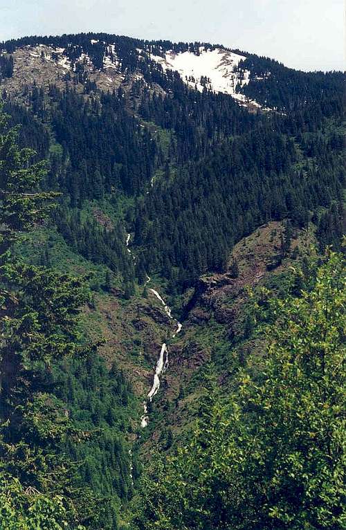
The finale chapter to the geologic story of the Mallard Larkins is the alpine glaciation of the Pleistocene. There have probably been several episodes where these glaciers expanded and contracted, but they generally never became extensive. However, the north side of the crest contains several hanging valleys that are dotted with numerous glacial lakes in cirques formed by the ice. As expected the results of this process are not well developed on the south side of the crest, but some examples can be found on Black Mountain, The Nub and probably elsewhere.
History
Settlement and Human Use

Black Mountain, the last active lookout

The stone foundation of the old Nub lookout is just visible (enlarge to see)
The North Fork Clearwater Canyon and associated mountains are on lands generally considered to have been used historically by the Nez Perce Indians. While there probably was some utilization of this area, the use would not have been high because of the absence of camas meadows used for food and gathering and the lack of trails to Montana that cut through the mountains further south.
The first minors and prospectors came into north central Idaho in the 1860s and concentrated on areas to the south were gold was discovered. Undoubtedly some of these early inhabitants would have explored the Mallard Larkin country, but without finding valuable ore, the area was not mined to any significant degree.
There were two primary factors bringing people into the North Fork Clearwater canyon – fire suppression and timber. The impetuous for the first was the huge forest fires of 1910 and other early years. Gifford Pinchot played on the fears of the public with the need to put fires out at all costs to initiate the U.S. Forest Service. The need to put out all fires was never the case and some even realized it at the time. But there was a need to install a land management agency to protect and conserve timber lands on a National scale to prevent random and sometimes extensive exploitation of the land. With a mission of saving the world from fires, the creation of the Forest Service fulfilled this management need.
As a result the agency built miles of trails for transportation between the many lookouts, cabin, and ranger stations that once dotted the back country. There were nearly 1,000 fire lookouts atop Idaho peaks at one time, with most being in north and north central Idaho. In the 1930s lookouts could be found on the summits of Mallard Peak, Larkins Peak, Black Mountain, The Nub and Isabella Point. Many summits immediately encircling the Mallard Larkins also had lookouts. The closest Ranger Station to the Mallard Larkins was at Canyon at the mouth of Grasshopper Creek on the south foot of Black Mountain. For decades many people used these resources to quickly jump on and snuff out any fire as soon as it started.
As the minerals played out to the south and north, attention shifted to the next big resource – timber. Initially most the extensive harvests were south and west of the Mallard Larkins area on private and State timber grounds. Eventually large scale logging moved onto the Clearwater National Forest, with projects reaching the Mallard Larkins area in the late 1960s. Towns such as Headquarters sprung up and railroads moved millions of board feet of logs out to mills that popped up everywhere. The railroads never reached the Mallard Larkins or North Fork, but instead logs were floated down the river in huge log drives. These occurred yearly for decades until the early 1970s when the installation of Dworshak Dam near Orofino created the 53 mile long Dworshak Reservoir, which flooded the river to within a few miles of the mouth of Isabella Creek.
Far more people lived in the area in the past than presently. An increase in roads and air patrols made the need for lookouts and stationed fire fighters largely obsolete. Today many of the trails past workers used have vanished or on the way out. Black Mt. lookout remains manned, and Mallard Peak receives some private preservation efforts, but lookouts at Larkins Peak and The Nub are just rock foundations. The Nub lookout is interesting in that some rock foundation remains along with extensive historical artifacts. Its against the law to remove such interesting items, so just take pictures. While logging lasted longer than the lookouts, it is only a shadow of what it was historically. Most the immediate Mallard Larkins area has seen no timber harvest, but much has occurred on the fringes. The last active sale in the area took place in the early 1990s in lower Isabella Creek. And with the political pressures of the day, even timber sales with primarily ecological or restoration objectives are very difficult to implement.
It could be said the third wave of people in the area has started. This would be the increased human presence due to emphasis on outdoor recreation including such activities as hiking, fishing, river running, hunting and others.
The Ridgerunner

The Ridgerunner used these remote ridges to travel between the St. Joe and Clearwater coutnry

Skull Creek (entering from left) is where the Ridgerunner was caught.
No discussion of Mallard Larkins history would be complete without a mention of William Moreland, better known as the Ridgerunner. Orphaned by the age of 10, Moreland spent the next few years in and out of reform schools in the south. In the 1930s at the age of 31, he had left his native Kentucky home and was drifting around the Pacific Northwest. Eventually he ended up in Idaho and went into the mountains living alone and away from other people for many years in the North Fork Clearwater and St. Joe country. He did his best to live off the land, often in hollow cedar trees. Eventually he turned to breaking into cabins for food and shelter. He was especially active robbing the Mallard Larkins lookouts, cabins and Canyon Ranger Station. Authorities sought fruitlessly for years to catch him, but always lost the cat and mouse game.
Moreland got the name, Ridgerunner after a series of remarkable travels and escapes that made him famous and legendary. He would break into cabins in the North Fork Clearwater and then next day break into cabins near Avery, Idaho far to the north. Making the 40 mile trip overnight over the rugged terrain was a stupendous feat, especially since done in the dead of winter with several feet of snow on the ground. He was also known to run backwards for many miles to throw the trackers off his trail. Eventually he was captured living like an animal in Skull Creek on the east edge of the Mallard Larkins. Eight months later on Oct. 4, 1945, he was given a five year suspended sentence for burglary and released.
Moreland spend the next 18 years living the area, working for various logging companies, the Clearwater Timber Protective Association, private individuals the occasional unauthorized manning of vacant, remote Forest Service stations, declaring himself a government agent. His strangeness was tolerated but he got in trouble again after a falling out with Potlatch Corporation, which employed him for a time. He was seen sitting on a hill above a work camp eating Ritz crackers minutes before an explosion destroyed some heavy equipment. He was charged and hauled into court again. When asked about his presence eating Ritz crackers just before the explosion he admitted he was at the scene. When asked by the prosecutor what this proves, the Ridgerunner replied, “it proves I like Ritz crackers” to the thunderous laughter of the court room. He was acquitted but sent to the State Mental Hospital in Orofino where he stayed for a few years before returning to the mountains.
He continued in his odd ways, but was generally tolerated, even liked by most people. However in the 1960s as logging increased in the area he complained to a friend that “there are too many people here for me now” and he would be leaving the area. That was on the road near Aquarius and it was the last anyone knows about the Ridgerunner. Whether he left the area or if his bones are in the Mallard Larkins country will probably never be known.
Climate
 Looking west from the 700 road near the 240 trailhead.
The climate of the Mallard Larkins exhibits a strong Pacific maritime influence and represents the warm and moist extreme of forest environments in the Northern Rocky Mountains. Temperatures can exceed 100°F in July and August, yet protected slopes maintain sufficient moisture to support wet-site vegetation. Average summer temperatures are in the mid-60°s and in winter average around 20°F. Due to the abrupt elevation changes, temperatures can vary wildly from the lower to upper elevations.
The area receives about 41 inches of precipitation annually, occurring primarily in the form of rain and snow in the spring and winter. July and August are very dry with usually less than one inch of precipitation each month as a consequence of West Coast subtropical high pressure system shifting northward in late June causing the prevailing westerlies to carry dry subsiding air across northern Idaho. Most summer precipitation is associated with convectional storms that may occur frequently on warm afternoons. The lightning from such storms are the primary cause of wildfires that are so important to the ecology of the area.
Flora
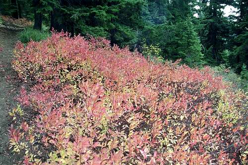 Fall huckleberry, Crag Peak
Vegetative Zones

Summit talus and krumholz, Crag Peak

Old growth cedar, lower Black Mountain

Fireweed in old burn, The Nub

Subalpine vegetation, Larkins Peak

Old growth mountain hemlock, Black Mountain
The moist climate and relatively low elevations give this area a dense cover of coniferous forests. Also a contributing factor to the lush vegetation in the area is a thick ash layer deposited by the collapse of Mt. Mazama several thousand years ago. Volcanic ash has remarkable water holding capabilities, which make the soils of north Idaho very conducive to supporting very mesic forests. Without the catastrophic eruption of Mt. Mazama, this part of the inland northwest would be covered with drier pine forest rather than the moist fir, cedar and hemlock that dominate the area today.
The moister zones are in the lower elevations, which are dominated by western redcedar. These trees grow to very large size and have at times been called the “redwoods of Idaho”. While they do not achieve near the height of the redwoods, they often are of similar diameter. The floor of these forests is fern dominated, mostly with sword fern, maidenhair fern and lady fern. However, 25 other fern species can be found here. It is in this zone where most of the coastal disjunct species occur. What is not a fern glade is often covered by dense devils club that can reach 15 feet in height and possess thick thorns that can shred cloths. Occasionally these forests can be found at higher elevations on gentle slopes that retain more moisture through less draining.
Higher up on the slopes the forest are more dominated by grand fir and Douglas fir. These forests are drier due to the draining of steeper slopes and occupy most of the area between the moist lowlands and the breaks into the mountain tops. Historically these forests burned much more frequently than today, which kept the slopes more open and brush covered. Now the forest are rapidly dieing off because that’s what these species due in this area after approximately 100 years. As a result the fuel loads are rapidly building up and the forest in many areas has become little more than a snag patch over increasing brush. A fire will clean it up someday, but with all the fuel on the ground, it will be very hot and possibly damaging to the soils and watersheds.
Above the fir the next general forest zone is dominated by mountain hemlock, with some representation of subalpine fir over beargrass, huckleberry, menziesia and whortleberry. If the topography allows, these forests would cover the tops of the highest mountains, which they do in part, but due to thin soils, south slopes, and extensive outcrops, much of the upper elevations are dominated by parklands and subalpine grasslands within the mountain hemlock zone. Where the hemlock stands are well developed, they generally are quite old and formerly qualify as old growth forests. The more open subalpine habitats are important for wildlife and add much to the scenic splendor of the area, especially in the fall when the huckleberries and other foliage turn. The dominant vegetation here is beargrass, mountain heather, assorted sedges, grasses (mostly green fescue) and numerous subalpine forbs. The rocky slopes and outcrops support compact juniper.
Unique elements
There are dozens of coastal plant species with most being found in the lower elevations where moisture and temperatures are higher, but there are a few subalpine species typically found in the Cascade Mountains. Also there are also species that are endemic to the area and are found nowhere else on earth. The list of coastal plants is far too long to present here, however some of the more noteworthy species being found in this part of Idaho are Henderson sedge, deerfern, red alder, white shooting star, Redwoods violet, phantom orchid, California sedge, luetkea, licorice fern, western starflower and Sierra wood-fern. Some of these species are very rare in Idaho, while others can be locally common. Some of the species endemic to this area are bank monkeyflower, Constance’s bittercress and evergreen kittentails. Clustered lady’s-slipper is a rare orchid that is found sparsely throughout much of the west including the Clearwater Mountains of Idaho.
Fauna
Wildlife
Goats on Heart Peak
The Mallard Larkins area nearly has a full, historic compliment of wildlife species. Mountain goats are especially abundant in the area and can be easily seen on any trip. They can be very inquisitive and move into empty camps to rummage through gear, possibly looking for food. Mountain goats can be thought of as the Mallard Larkins mascot. Deer and elk are also present. The elk population in the Clearwater Mountains was very small historically, but as a result of huge forage producing fires in the early 1900s and modern game management, the population exploded. Now after a combination of factors including some severe winters, fire suppression, decline of forage producing logging, hunting pressure and the introduction of wolves, the elk population is in serious decline. Before the wolves returned, the cougar and black bear were the primary predators in these mountains. It is believed that perhaps five wolf packs are active in the area. Coyotes were also abundant, but have been largely pushed out by the highly territorial wolves.
Other rare species known to inhabit that area include the fisher, pine marten, wolverine and possibly the lynx. Bald eagles also turn up during the winter to feed on spawning kokanee from the Dworshak Reservoir. Young fledgling eagles have been seen during the summer indicating a resident population must be present, yet little is documented about this. There are occasionally reports of grizzly bears in the mountains, but the official position of the Idaho State Fish and Game, US Forest Service and US Fish and Wildlife service, which manages rare species under the Endangered Species Act, is that there are no grizzly bears in north central Idaho. The reports are probably based on misidentifications of brown colored black bears, or perhaps occasional far wandering grizzly bears passing through the area. The grizzlies were here historically but were lost to extermination hunting and the decline of anadromous fish which were a staple of their diet.
Fish

Lost Pete Creek
Historically few if any of the mountain lakes in this area had fish. Native fish populations included cutthroat trout, bull trout and rainbow trout in the rivers and larger streams surrounding and draining the Mallard Larkins peaks. Historically anadromous species such as Chinook salmon and steelhead spawned in these streams in large seasonal runs. In the 1960s the Idaho Department of Fish and Game began stocking several of the area lakes with rainbow, west slope cutthroat trout, rainbow-cutthroat hybrids, Kamloops rainbow, brook trout, and even grayling. Emphasis has moved away from brook trout, which can move into the streams where they out compete the native species, especially the Threatened bull trout. The native stream fisheries are under much more restrictive regulations than in the past, which has resulted in increased stocks of these fish. Unfortunately the anadromous fish runs were destroyed by the construction of the massive Dworshak Dam near the mouth of the North Fork Clearwater River. Kokanee salmon (a landlocked variety of sockeye salmon) have been introduced in Dworshak reservoir and make large spawning migrations into the North Fork system during late summer and fall.
Stocking levels in the high lakes vary as to numbers and species deposited and there is no set schedule. Knowing which lake had what planted and when is difficult, but some date is presented here. Since 2001, Northbound Lake has been stocked with 9,000 cutthroat trout. Mallard Lake hasn’t been stocked since 1981 when the game department dropped in 1,174 rainbow-cutthroat hybrids, thus this may not be a good destination if fishing is your purpose. Fawn Lake, which is 5 miles off Trail 111 has had almost 10,000 westslope cutthroat fry planted since 2001. More than 20,000 Kamloops have been planted in each of Heart Lake and Skyland Lake since 2001. Fishing for trout in these waters is considered a prime part of the experience in the Mallard Larkins area.
Lakes
 Heart Lake and Northbound Lake
There are 21 lakes within the Mallard Larkins Pioneer boundaries and at least 17 more in the primitive areas in the vicinity. Many of these provide excellent back country camping with excellent fishing that includes rainbow trout, cutthroat trout, brook trout and grayling. No fish are native in these lakes however and are dependant on periodic stockings. The mosquitoes in these areas can be horrendous most of the year. In the fall, fishing and scenery often improve, and people and mosquito clouds decline. Below is a list of the lakes within the Pioneer Area, elevations are approximate.
| Lake | Elevation |
| Black Lake | 6,380 |
| Blue Lake | 5,340 |
| Cliff Lake | 5,780 |
| Crag Lake | 5,900 |
| Devils Lake | 5,140 |
| Fawn Lake | 5,912 |
| Gnat Lake | 5,840 |
| Heart Lake | 5.980 |
| Hero Lake | 5,200 |
| Jug Lake | 5,500 |
| Larkins Lake | 5,580 |
| Mallard Lake | 5,740 |
| Mud Lake | 5,860 |
| Northbound Lake | 5,436 |
| Nub Lake (north) | 5,940 |
| Nub Lake (south) | 5,840 |
| Skyland Lake | 4,799 |
| Slide Lake | 6,100 |
| Steve Lake | 6,020 |
| Unnamed (Crag cirque) | 6,300 |
| Unnamed (east Fawn) | 6,060 |
Camping

Black Lake
Backpackers will find excellent camping at any of the many lakes in the Mallard Larkins Pioneer Area. However, some of these may be difficult to reach or get crowded on nice summer weekends. Research and plan your camping spot and have alternatives.
South Side
For those wishing to car camp for an early start or day hikes near the trailhead the only close campground is Aquarius Campground (9 units) at the bridge over the North Fork Clearwater River on the 247 road. This provides camping close to the southern trailheads. Washington Creek Campground (23 units) is also an option but its much further up the river and requires 20-30 minute drive depending on road conditions. For locations and details on these and other Clearwater National Forests campgrounds visit the camping page of that Forest’s website. The best options for car camping in the area besides Aquarius Campground would be the numerous undeveloped dispersed campsites along the river that start five or six miles east of Canyon Work Center. Several pullouts with good tent sites and often a sandy beach can be found. However, these can become busy during summer weekends. Other dispersed campsite options are along Beaver Creek along the 247 road south of the river. These are often used by loggers and are on private land. The Potlatch Corporation once allowed free use of their land, but in 2007 has begun charging user fees (see Red Tape).
North Side
Camping opportunities from the north are more limited close to the trailheads. Some dispersed camp sites may be found along the St. Joe River Road or near the trails themselves, but the only designated campgrounds are not very close. Mammoth Springs north of the Mallard Larkins area on road 201 is an option as are the campgrounds at Fly Flat and Spruce Tree near Red Ives on the St. Joe River.
Another unique option for staying in the area is the rental of Surveyors Ridge Lookout. This is near the 111 trailhead, which may limit isolation and privacy, but may provide a good lodging experience with easy access and incredible views.
Red Tape
There are no fees to use any of these public lands.
Use of private timber lands that are intermingled with or adjacent to public ground has always been free, but in April 2007 that will change. Fees will apply to anyone driving or parking on Potlatch timber grounds. The annual fees include: $100 for motor homes; $50 for trucks, cars, camp trailers and SUVs; $25 for ATVs and motorcycles; $25 for snowmobiles; $25 for horse riders; and $10 per person for those on foot or bicycle (children 16 and under are free). It’s interesting that the Forest Service must provide free access to owners of embedded private grounds, but the same private land holders can charge (or deny) you to cross their grounds to reach public lands.
Permits can be purchased at www.potlatch.com and at local vendors.
Additional Information and Current Conditions
High broken falls on Black Mountain
Contact the North Fork Ranger District of the Clearwater National Forest for information and current conditions.
North Fork Ranger District
12730B Highway 12
Orofino, ID 83544
(208) 476-4541
Canyon Work Center (summer only)
(208) 476-8306
St. Joe Ranger District
St. Maries Office
222 S. 7th St., Suite 1
St. Maries, ID 83861-0407
(208) 245-2531
FAX: (208)245-6052
Federal Building in downtown St. Maries
Avery Office
HC Box 1
Avery, ID 83802-9702
(208)245-4517
FAX: (208)245-6246
6 miles west of Avery on Forest Hwy. 50 (St. Joe River Rd.)
Clarkia Office
54495 Hwy 3
Clarkia, ID 83812
(208) 245-1134
FAX: (208) 245-2254
1 mile north of Clarkia on Hwy 3
Maps of the area that included marked trails may be obtained from the Panhandle National Forest headquarters (208-765-7223) or the St. Joe district office (208-245-2531).
Refer to individual mountain pages in this group for more detailed information.
NOAA Forecast