
-
 13421 Hits
-
 90.48% Score
-
 32 Votes
|
|
Route |
|---|---|
|
|
37.62230°N / 118.9068°W |
|
|
Hiking |
|
|
Fall |
|
|
Most of a day |
|
|
road and trail |
|
|
Overview
The Laurel Creek trail leads from the Sherwin Creek Road up Laurel Canyon to the beautiful Laurel Lakes in a pristine sub-alpine setting. The trail is in fact an abandoned mining road and only passable for true four-wheel-drive vehicles with high clearance. If you have such a vehicle and are up to the task you can drive all the way to Laurel Lakes situated beneath Bloody Mountain at an elevation of about 9,830+ feet. In contrast to the description in Secor’s “The High Sierra” the distance to the Laurel Lakes from the Sherwin Creek Road is much longer than the mentioned 3.25 miles. According to my GPS the distance to the lakes is closer to 5 miles. At about 4.5 miles from the Sherwin Creek Road (37.5793; -118.9054) a narrow trail leads south away from the road up the mountainside to the saddle between Laurel Mountain to the east and Bloody Mountain to the west (~10,770’). From the saddle class 1-2 routes lead along the ridges to the respective summits. Beyond the saddle the trail drops down into the Convict Creek drainage.
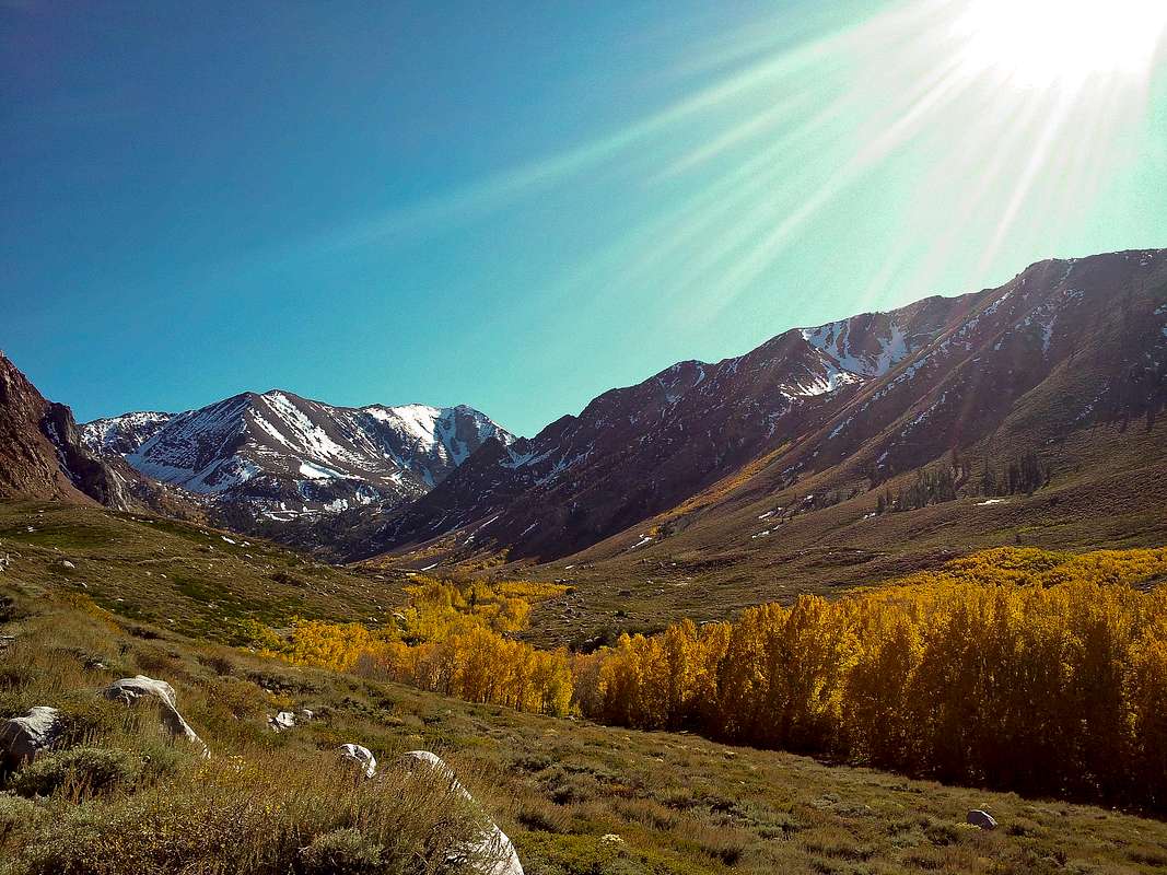
Although most of the time you will hike on a rough dirt road the scenery in Laurel Canyon is absolutely stunning and very well worth the effort. In fall, Laurel Creek is lined with beautiful and plentiful aspens in all their fall glory. Since the distance to the lakes and the condition of the road seems to (thankfully) distract many people, chances are that you have the canyon all for yourself.
The roundtrip from the Sherwin Creek Road to the Laurel – Bloody Saddle is about 13 miles with almost 4,000 feet of elevation gain.
|
Getting There
You can get to the start of the four-wheel-drive road from Highway 395 or the Old Mammoth Road. From Highway 395 take the exit to Sherwin Creek Road (south of Mammoth Lakes exit) and continue on the gravel road west for 1.5 miles to the Laurel Creek trailhead. From the Old Mammoth Road in Mammoth Lakes take the Sherwin Creek Road (near the Snowcreek Resort) and continue in easterly direction for a little more than 4 miles to the trailhead. At the trailhead a sign directs to Laurel Lakes. You can park your car in a small turn-out off the Sherwin Creek Road or drive up the rough dirt road as far as you feel comfortable.
The begin of the dirt road does not look too bad and can be attempted more easily but be assured that you will need a high clearance and four-wheel drive vehicle and the skills to use it very soon.
Trail Description
From the trailhead off Sherwin Creek Road (7,300’) the rough four-wheel-drive road leads straight up and climbs the glacial moraine on the east side of Laurel Creek. You simply follow the road which ascends the moraine in southwesterly direction rather steeply. After about 1.8 miles and 1,200 feet of elevation gain the road turns directly to the south and enters the proper Laurel Canyon. As soon as you enter the canyon(~8,450’) you will be very close to the creek and are surrounded by quaking aspens. In fall, a colorful spectacle awaits you here. The road now ascends on the eastern side of the canyon moderately steep 1,000 feet in the next 2 miles. During that time you have great views at Bloody Mountain dominating the southern end of the canyon. At around 9,400’ the road switchbacks and climbs more steeply up the canyonside. At about 4.5 miles you will reach the unsigned trailhead to the Laurel-Bloody saddle at ~9,860’. Be alert as the trail is easily missed. From here you can continue on the road for less than one mile to the Laurel Lakes.
| Laurel Canyon | Laurel Lakes |
|---|---|
 |
 |
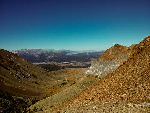
To hike to the Laurel-Bloody saddle leave the road and take the narrow trail that leads steeply in switchbacks up the ravine. After 5.5 miles (from the start) and at an elevation of about 10,250’ the grade eases and you will reach a small wooded, almost flat area. You will have the first view of the saddle from here. Cross this area and approach the steep switchbacks that lead to the saddle at ~10,770’. Breathtaking views into the Convict Creek drainage and countless peaks to the south and west will command you to linger here and soak in the scenery. From the saddle, another steep 1,000 feet will lead you to the summit of Laurel Mountain to the east or less than 2,000 feet to the summit of Bloody Mountain to the east. The ridge up to Laurel Mountain is rated class 1 and up Bloody Mountain class 2.
Deliberate your options, assess your stamina, but remember it’s more than 6 miles back to the car.
| Saddle | Laurel Canyon |
|---|---|
 |
 |
Essential Gear
If you want to drive up Laurel Canyon make sure you have the right vehicle and necessary skills to drive it. Otherwise no special equipment, gear, or permits are required here.