
-
 17825 Hits
-
 92.32% Score
-
 38 Votes
|
|
Area/Range |
|---|---|
|
|
37.71660°N / 118.8843°W |
|
|
Hiking |
|
|
Spring, Summer, Fall, Winter |
|
|
Overview
Long Valley Caldera, situated at the boundary between the Sierra Nevada and the Basin and Range Province in eastern California, is among the largest quaternary rhyolitic volcanic centers in North America. The elliptical caldera is about 10 by 20 miles in size. The caldera floor is at elevation 6,500 feet in the east and 8,500 feet in the west. The walls of the caldera approach 11,500 feet in the west and 7,550 feet in the east. Magma still underlies the caldera and heats underground water. The heated water feeds local hot springs and fumaroles and powers local geothermal power plants producing a combined 40 megawatts of electricity.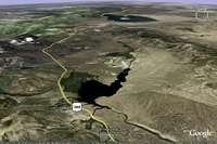
South of the Caldera is Crowley Lake, to the west is the Eastern High Sierra, further north is the Mono Basin with Mono Lake and Mono Craters, to the east the Glass Mountain Range. The Long Valley Caldera and the surrounding area host numerous outdoor recreational activities, including mountaineering, climbing, hiking, fishing, horseback-riding, biking, mountain biking, and swimming mostly in the summer, and skiing, cross-country skiing, snow-shoeing, and snow-mobiling in the winter.
Formation
Volcanic activity started in that area approximately 4 million years ago at about the same time as the present-day Sierra Nevada was uplifted and tilted. During the uplift, the earth’s crust was stretched, faulted, and broken, and magma made its way upward along the broken rocks in the fault zones. Early volcanic activity was mainly basaltic, which changed to silica-rich, stiff rhyolitic magma over time.The Long Valley Caldera was formed by a cataclysmic eruption of the Long Valley volcano 760,000 years ago that blew out 150 cubic miles of superheated ash (more than 2000 times larger than the 1980 Mount St. Helens eruption). Half of this ash was ejected into the air and formed a column of ash eight miles high. Larger fragments fell back to the ground near the volcano and the smaller fragments were carried as far east as Nebraska and Kansas. The other half of the eruption consisted of pyroclastic flows (rapidly moving flows of glowing hot ash) that speeded down the flanks of the volcano. Most of the flows went down the Owens Valley as far as present-day Big Pine. The air-fall ash and ash flows that were deposited during the eruption of the Long Valley Caldera are known as the Bishop Tuff. After the eruption of the Long Valley volcano, the magma chamber underneath the volcano was nearly emptied causing the volcano and the roof of the magma chamber to collapse. This event lead to the formation of a large depression that geologists call “caldera”. Immediately after the eruption and collapse the caldera was about two miles deep. However, much of the material ejected straight into the air fell back into the depression to fill the caldera two-thirds to its rim.
After the catastrophic event, volcanism continued on the caldera floor. Pressure increased within the magma chamber again and forced the overlying rocks upward, forming a resurgent dome, which now rises 1,500’ above the valley floor. Eruptions along the periphery of the caldera (in 200,000 year intervals) produced thick, steep-sided rhyolitic lava flows, domes, and volcanoes. Mammoth Mountain is one of these volcanoes. During the last of the glacial periods, a large lake occupied the depression of the Long Valley Caldera. The resurgent dome was an island in the lake. The lake was dammed by the Bishop Tuff at the south end of Lake Crowley. Owens Gorge was formed when this Pleistocene lake cut through the dam and then carved a steep gorge through the ash flows of the Bishop Tuff.
Recent Geological History
Although no volcanic eruptions are known to have occurred in the Long Valley Caldera in recent history, earthquakes occur frequently. These earthquakes are caused by movements along faults and by the pressure of magma rising beneath the Earth’s surface. In 1872, the magnitude 7.6 Owens Valley earthquake was felt throughout most of California, and a number of moderate (magnitude 5 to 6) earthquakes have shaken the Long Valley area during the last century.A period of ongoing geologic unrest in the Long Valley area began in 1978 when a magnitude 5.4 earthquake struck 6 miles southeast of the caldera. This temblor ended two decades of low activity in Eastern California. The area has since experienced numerous swarms of earthquakes, especially in the southern part of the caldera and the adjacent Sierra Nevada. Following four strong magnitude 6 earthquakes in May 1980, the U.S. Geological Survey (USGS) detected dome-like swelling in the middle of the Caldera. Their measurements showed that the center of the caldera had risen almost a foot since the summer of 1979. This continuing swelling, which by early 2000 totaled nearly 2.5 feet and affects more than 100 square miles, is caused by new magma rising beneath the caldera.
In response to these signs of renewed volcanic unrest, USGS intensified their monitoring of the Long Valley area. During the early 1990s, trees began dying off at several places on Mammoth Mountain on the southwest edge of Long Valley Caldera. Studies showed that the trees are being killed by large amounts of carbon dioxide gas seeping up through the soil from magma deep beneath Mammoth Mountain. Such emissions of volcanic gas, as well as earthquake swarms and ground swelling, commonly precede volcanic eruptions. When these events precede an eruption of a central vent volcano, such as Mount St. Helens, they normally last only a few weeks or months. However, symptoms of volcanic unrest may persist for decades or even centuries at large calderas, such as Long Valley Caldera. Recent studies indicate that only about one in six such episodes of volcanic unrest at large calderas worldwide actually culminates in an eruption.
Points of Interest
Getting There
The main access to the Long Valley Caldera is via Highway 395. Highway 395 connects the Mojave Desert in the south to Reno in the north. The distance from Los Angeles to Mammoth Lakes to the west of the Caldera is about 310 miles, the distance from Bishop to Mammoth Lakes about 42 miles.Secondary Highways leading into the Long Valley Caldera are the Owens River Road to Big Springs Campground to the north and the Benton Crossing Road to the south. Dozens of dirt roads criss-cross the caldera. The major tourist center near the Long Valley Caldera is Mammoth Lakes with plenty of resorts, hotels, motels, and cabins. Besides Mammoth Lakes there are many other resort cabins around Long Valley Caldera, such as around June Lake to the northwest, at Convict Canyon to the west, at McGee Canyon to the southwest, and around Toms Place south of Crowley Lake. In summer campgrounds are scattered all around the area, in- and outside the caldera.
Current Weather
References
guide to HIGHWAY 395 los angeles to reno by Ginny Clark, Western Trails Publications, 1990Geological Trips Sierra Nevada by Ted Konigsmark, GeoPress, 2002
United States Geological Survey
External Links
Mammoth LakesConvict Lake Resort
USGS
Long Valley Observatory