
-
 18196 Hits
-
 82.48% Score
-
 15 Votes
|
|
Route |
|---|---|
|
|
37.61080°N / 118.9462°W |
|
|
Hiking |
|
|
Spring |
|
|
Half a day |
|
|
Sherwin Lakes Trail

|
|---|
From the parking lot the trail heads south, crosses Sherwin Creek over a wooden bridge and leads on a gentle slope through a beautiful conifer forest. The trail then climbs steeply in many switchbacks up the forested slope, parts of an ancient glacial moraine. Eventually, it levels off and leads in westerly direction towards the Sherwin Lakes. One has beautiful views north towards the town of Mammoth Lakes and west towards the Sherwin Range throughout the hike. The trail eventually turns south and many use trails lead to the west downhill to the smaller Sherwin Lakes.
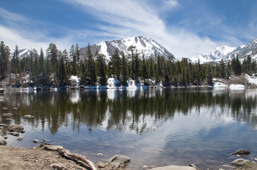
Staying on the main trail one approaches quickly the highest and largest of the Sherwin Lakes at an elevation of about 8,700 feet. The setting is nothing less than spectacular. Gorgeous conifers along the lakeshore provide shade and invite for a prolonged rest. Bloody Mountain is visible above the treetops. Unnamed peaks of the Sherwin Range stimulate the fantasy of future hikes in the area. The hike to the Sherwin Lakes seems very popular with locals, who use it as a quick early morning workout. The roundtrip to the Sherwin Lakes and back is about 4.5 miles with a little bit less than 1,000 feet of elevation gain.
| View north towards Mammoth Lakes | Level portion after the steep ascent |
|---|---|
 |
 |
| Sherwin Lakes | Peaks south of Sherwin Lakes |
|---|---|
 |
 |
If one feels to do more, the trail continues past the Sherwin Lakes in southerly direction towards Valentine Lake, a more alpine lake surrounded by craggy peaks. The trail towards the Valentine Lake leads through an increasingly open conifer forest and enters the John Muir Wilderness about one mile after the Sherwin Lakes. Shortly before entering the wilderness another trail leads back north towards Sherwin Creek Road to another trailhead further east. The hike to Valentine Lake from the trailhead at Sherwin Creek Road is about 4.5 miles one way with about 2,000 feet of elevation gain.
Getting There
The Sherwin Lakes trailhead can be accessed via the Sherwin Creek Road off Old Mammoth Road in the town of Mammoth Lakes. Once on Sherwin Road drive a little over one mile to a junction, turn right on a dirt road for less than half a mile to a fork, turn left to the parking area. The Sherwin Creek Road can also be accessed from the east from Interstate 395 south of the turn off to Mammoth Lakes. The dirt road should be passable to all cars.