Leon Pk & Pt 10855B (Grand Mesa)
Leon Pk- (11236')- CO Rank 1670
Mesa county, CO county highpoint
Pt 10855B- CO Rank 1857
June 17, 2007
3.9 miles RT, 1200' gain
Participants: Patrick Thornley and Kevin Baker
Slideshow
Patrick and I are coming close to completing the CO county highpoints with only a few left on the western slope. We thought we would combine Leon on the Grand Mesa with Lamborn in the West Elks in the same weekend. Pat drove us to Parachute on I-70 Friday night, which was a nice short drive the next morning to Grand Mesa.
This was the first time I have hiked on the Grand Mesa, and it would not dissapoint. We left Parachute around 6:30 and followed Covill & Mitchler's directions to the Johnson & Weir campground. The roads were dry and there wasn't much snow left in the trees. Leon is a short 3 mile/800' hike, so I had grand plans of adding nearby 10855B and the spectacular Crag Crest, which is probably the most popular hike on Grand Mesa.
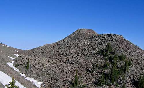
We set off at 8:07am for Leon, heading for Sissy Lake, crossing the spillway and heading left at the sign. We passed Round Lake and Sissy Lake on the right following the decent trail. Above Sissy Lake, the trail was harder to follow, so we just headed up the n.w. trending ridge to Leon. There was a lot of boulder hopping on the sharp basalt rock, but it was reasonably stable.
![Leon Peak summit]() The jumbled choss pile that is Leon Peak.
The jumbled choss pile that is Leon Peak.
Just below the summit we followed a snow filled gully at the bottom of a depression after loosing some elevation, then did the balancing act up huge boulders to the top, arriving at the old fire lookout on the summit at 9:08. We hung around and enjoyed the views for 30 minutes, then headed pretty much due south to hit the ridge sooner. We followed the ridge down to Sissy Lake, briefly loosing the trail. Leon keeps you on your toes with routefinding, but a GPS really makes things easy. We were down at 11am.
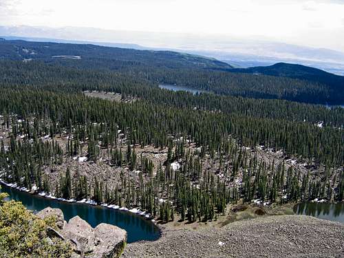
For nearby 10855B, we just followed the road from the TH until it headed south and bushwacked to the gentler north side of the peak if you want to call it that. From there, it's a loose, steep boulder hop of 150' to the summit. There was a register placed by the legendary Mike Garratt in '04, and we were the first to sign it. We were back to the car from this convenient 10er in an hour.
A Classic Loop Hike on Crag Crest (Grand Mesa)
Crag Crest (11189’)- CO Rank 1691
Via Crag Crest Natl Recreational Trail (east to west)
6.5 miles RT, 1300’ gain
June 17, 2007
To cap off the day on the Grand Mesa, Pat and I decided to hike the spectacular Crag Crest National Recreational Trail, which is a loop that climbs to a somewhat narrow ridge that affords sweeping views of the mesa. Pat offered to give me a car shuttle on this so I could enjoy the whole loop, and I’m glad he did.
![Crag Crest from Leon Peak]() The long ridge of 11er Crag Crest as seen from Leon Pk.
The long ridge of 11er Crag Crest as seen from Leon Pk.
We set off from Eggleston Lake at 12:37pm. Some clouds were building, but we had a good shot at squeezing this in. The trail is wonderfully constructed as it moderately climbs to the ridge crest, weaving past a couple pristine lakes en route. There were quite a few downed trees to deal with, but this didn’t compare to a huge blowdown of trees near Bullfinch Reservoir. There were huge aspens laying everywhere, but this popular trail was cleared. Apparently a huge wind storm blew through in 2006.
![Blowdown near Crag Crest]() A huge blowdown of aspen trees from a storm in 2006.
A huge blowdown of aspen trees from a storm in 2006.
Once we got on the ridge crest, a dark cloud overhead began to spit some rain. No thunder or lightning though and to the west it looked promising, so I pressed on quickly. Once I saw the summit, it was still ¾ mile away with a lot of ups and downs, but you can cruise this ridge. It drops to about 3 ft wide in spots, but isn’t really exposed. I topped out at 1:45 and it looked like the weather would hold to do the whole loop.
![Cool window on Crag Crest]() A cool window looking down to lakes below on Crag Crest.
A cool window looking down to lakes below on Crag Crest.
Pat and I parted ways and I headed west down the ridge. The west side is much gentler and wide with some huge snow drifts over the trail. The trail stays over 11K for quite awhile before ducking into the woods. I soaked up the views of the many lakes below, enjoying this sidewalk in the sky. The trip down was uneventful and pleasant, and I popped out at the west TH on CO-65 at 3:27. I started walking up the road and Pat was there about 5 minutes later. Perfect! This is a classic hike that a wide variety of fitness levels can enjoy. Give it a shot if you’re in the area.
A CO County Highpoint Finisher on Lamborn
Mt Lamborn (11396’)- CO Rank 1604
Highest point in Delta county, CO
Landsend Pk (10806’)- CO Rank 1882
12.2 miles RT, 6070’ gain
June 18, 2007
Participants: John and Renata Collard, Patrick Thornley, and Kevin Baker
This was a special hike as it would be Renata’s final CO county highpoint! Pat had been turned around twice by muddy roads on Lamborn, so we elected to go with the west approach via Bell Canyon. This would add more vertical, but if the roads were muddy again we could walk the 4WD portion of the road. Here are directions to this TH since the directions we had were sketchy:
From Hwy 187 (Grand Ave) and 3rd in Paonia, take 3rd east to Onarga. Take Onarga (4100) south 1.9 miles to N-25. Right on N-25 (west) .4 mile to 4050, 4050 south 1.5 miles to a T-intersection. Take a left at the intersection up the forest road. Right after 2.6 miles or park here if you don’t want to mess with ruts in the road and a couple stream crossings. The TH is ¾ mile up this road at 7400’. Pat elected to park at 6800’. A stock 4WD should be able to get to the last junction or to the TH with careful driving. Don’t attempt this road when muddy!
We set out at 7:10am with not a cloud in the sky. It would turn out to be another bluebird day, which seems to be the theme when I hike with John and Renata. I led the way initially up the heavily wooded trail and wished I wasn’t as we began to get attacked by cobwebs and inchworms! I had never seen anything like this. I would look down and have 10 or more on my shirt and shorts at times. Whoever was in front got hammered. At least there wasn’t any mosquitoes!
There were quite a few fallen aspens over the trail to deal with from a recent storm, but we made good time. The trail crosses Bell Creek many times, climbing steeply up the canyon. We came to a confusing sign about 400’ below the Lamborn/Landsend saddle and took a break there. We headed left to the 9660’ saddle, which took us up a series of two steep grinds to the summit ridge.
Whoever designed the trail pretty much gave up here as it pretty much went straight up. Lamborn isn’t climbed too often, so the vegetation was starting to do a number on my legs. We finally topped out on the impressive south ridge of Lamborn.
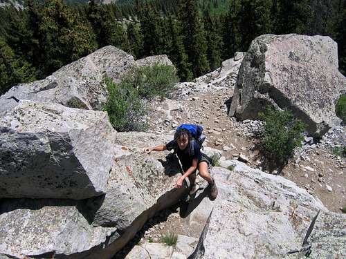
![The south ridge of Lamborn]() Renata Collard crests the south ridge of Lamborn.
Renata Collard crests the south ridge of Lamborn.
Renata made her way up a few easy class 3 moves and came to the end of her Colorado county highpoint journey at 11:08am. She is the first Czech native to complete Colorado and I was with her on I think 14 of the 64 counties.
![Lamborn summit moves]() Renata Collard about to complete her last CO county highpoint!
Renata Collard about to complete her last CO county highpoint!
Congrats Renata! Pat topped out a short time later and we took a long break on this awesome perch, a nice place to finish up on.
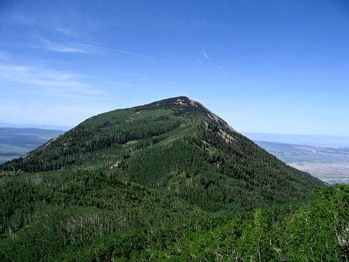
The weather was looking great, so John, Renata, and I decided to head over to 10er Landsend. Just a bunch of aspens to deal with, how hard could it be?
![Landsend Peak]() 10er Landsend Pk from Lamborn, which turned out to be bushwacking hell.
10er Landsend Pk from Lamborn, which turned out to be bushwacking hell.
We bombed down the trail and arrived back at the saddle at 1pm. We parted ways with Pat and set off on the bushwack, which was a nightmare. Initially it wasn’t bad as we followed game trails, skirting minor bumps to the left. We hoped to avoid going over Pt 10079, but we did it anyway.
The last 800’ was a mess of downed aspens, so the going was very slow. We were all beginning to feel the heat as well and I was worried about running out of water. Dreams of Gatorade on the summit helped me press on. I was startled by a powerful, tall, black animal charging through the woods in front of me. It was a moose! John and Renata thought I was hallucinating, but it had to be one because it was too huge to be an elk. After what seemed to be an endless talus hop, we topped out around 2:50. We were too tired to enjoy the summit, too much effort for a 10er off any of my lists!
![Lamborn Pk from Landsend]() The steep south slopes of Lamborn from Landsend.
The steep south slopes of Lamborn from Landsend.
On the descent, we stayed more on the ridge then bypassed heading all the way back to the saddle. The deadfall wasn’t bad at first, but it worsened as we descended. We sidehilled across numerous talus fields, a balancing act that never seemed to end. I never wiped out but came close. John did a great job of leading us back down to the trail and we staggered upon it at 8600’. The trail felt like a superhighway now, but we still had to do battle with the inchworms which were out in full force. We finally popped out of the woods and were back at the car at 5:45. Don’t attempt Landsend unless you have a sick pleasure of extreme bushwacking!
Comments
No comments posted yet.