
-
 21032 Hits
-
 83.77% Score
-
 18 Votes
|
|
Mountain/Rock |
|---|---|
|
|
43.76209°N / 103.39523°W |
|
|
Custer |
|
|
4780 ft / 1457 m |
|
|
Overview
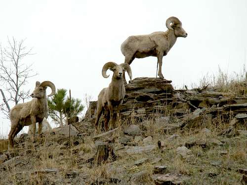 Bighorn sheep often seen in the Lovers Leap area
Lovers Leap is a ridge highpoint with a massive granite outcropping above the Galena Creek canyon in Custer State Park, South Dakota. The outcropping is next to the highpoint on the ridge, and is nearly 500 feet above the stream below. Because the rock juts out from the ridge, it offers great views of this area of the Black Hills. Summits easily identifiable from the rock include Harney Peak, Cathedral Spires and Mount Coolidge. . Black Hills rock climbers seem to like the granite here, though they are more often seen on the granite wall behind the state park headquarters less than a mile north-northwest. There are many summits named “Lovers’ Leap” around the USA. Like the Black Hills’ Lovers Leap, most have similar stories about the origin of the name. The story for this Lovers Leap tells us that from the high rock outcropping of this summit, many years ago two young Native American lovers leaped to their deaths.
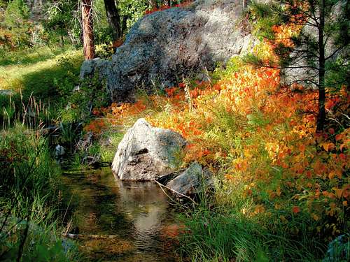 Some early fall color along Galena Creek, near the Lovers Leap trail.
The hike to the summit is along a well-defined trail through thick forest of mostly Ponderosa pine. However, once the trail drops to parallel Galena Creek, aspen are the most common trees along the trail. With the lush ground cover and the aspen trees along the creek, this hike becomes especially popular when fall colors are at their peak. Hikers will often see deer along the stream, and occasionally elk or buffalo. If you are one of the rare hikers who discover your path blocked by a buffalo, please be aware of the signs that may indicate to you if they are in an aggressive mood. That would include lifting their tail or rolling their tongues. A female buffalo with a calf may feel protective, so you may have to find a way to bushwhack through the forest to give them a wide margin as you go by. There are mountain lions in this region, but they are not seen here often, due to the number of visitors to the area. Bighorn sheep are often seen near the mouth of the canyon, where Galena Creek joins Grace Coolidge Creek. The 1988 Galena fire burned 16,000 acres to the west and the damage from that fire is still visible. Significant forest fire damage in the black Hills over the last 30 years, compounded with pine beetle kill, has led to some very tough fire control regulations, including no fireworks.
Getting There
 Galena Canyon View
 Galena Creek Ice
The Lovers Leap trailhead is located off the highway, behind the old schoolhouse near the State Game Lodge. The best way to get to the State Game Lodge from downtown Custer, is to travel east on Highway 16A for 13.5 miles. This is a busy area, with not only the State Game Lodge but also the Norbeck Center, campgrounds, the general store and more. If you are traveling from Rapid City, the best way to get there starts from downtown by going 19 miles south on Highway 79 to Highway 36. Turn west on Highway 36 and go 9 miles, where the highway merges with Highway 16A. 2.8 miles from the junction is the State Game Lodge.
Route
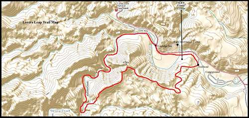 Lovers Leap Trail at Custer State Park
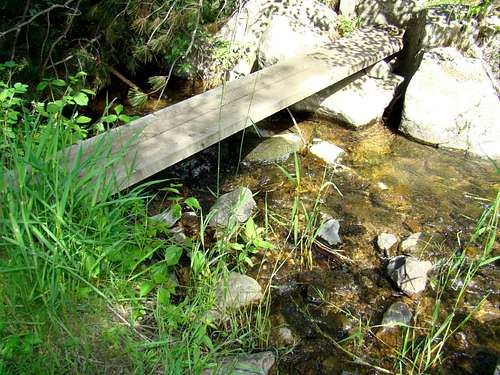 Galena Creek "bridge"
From the trailhead, hikers will ascend about 580 feet to the summit of the ridge. The altitude at the trailhead is approximately 4,200 feet. The loop is about 3 miles long, with the first mile being where all the climbing is done. This is the part of the trail that gets a “strenuous” rating in some of the trail brochure descriptions. The trail nearly evens out by the time you reach the summit. It is well-marked at the summit area with several signs. The photos ops are great, with the best views to the northwest toward Harney Peak and Cathedral Spires. From the summit, the trail begins a gradual descent to Galena Creek, where the trail then parallels the creek until you come to some park employee dorms and houses, as well as a RV campground. Please be aware there are many stream crossings in this segment of the loop. Recently, anchored plank “bridges” have been installed at a number of the crossings. But not all have them yet. You may have to do some shallow wading or jumping. Follow the road back to the General Store, where your final portion of the route will take you by trail back to the old schoolhouse area. When you are along Galena Creek, please be aware of poison ivy. This is also the area you would be most likely to see buffalo. Ticks are a possibility in the grassy areas along the creek. So if you go off trail, insect repellent is a good idea.
When To Climb
This route is open year-around. No doubt that weather will dictate whether one chooses to try this climb or not. Either summer lightning or winter blizzards will turn back careful climbers. For the latest weather for Custer State Park, click here: Custer State Park Weather
Red Tape
 Galena Creek
 Grace Coolidge Creek Fall Reflections
There is no red tape to hike this route. But, there are some regulations that would affect what you do while you are here. Some of the more apparent regulations would include carrying no firearms, no fireworks, and no campfires anywhere, except in designated places. If you are interested in learning more about the state park regulations, please click on the link below: South Dakota State Park Regulations
Camping
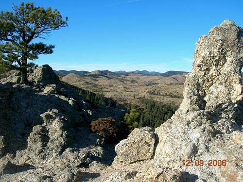 Summit view toward Harney Peak & Cathedral Spires.
Custer State Park is large and offers many opportunities for hiking, climbing, camping, and much more. You can reach their office by phone at: (605) 255-4515 Or, you can check out these websites:
Custer State Park Resorts Lodging
If the park is full or you have other preferences, the town of Custer is just 13.5 miles west and offers more campgrounds and a variety of lodging. You can reach their chamber of commerce at: (800) 992-9818 You can also access their website at:
Custer, South Dakota Chamber of Commerce
Information Resources & Links
Black Hills National Forest Information
Maps
The Norbeck Center, across the road from the General Store and the State Game Lodge, has a wealth of Black Hills information for visitors. Much of it is free, but you can also purchase National Geographic’s Black Hills maps there. They do have some simple state park trail maps for free there, and the people working behind the counter are normally quite helpful to answer specific questions.