
|
|
Route |
|---|---|
|
|
38.39460°N / 110.2601°W |
|
|
Mountaineering, Scrambling, Canyoneering |
|
|
Spring, Fall |
|
|
A long day |
|
|
Class 5.2-5.3 if ascending from top of the big drop (no exposure) |
|
|
Overview
This is the section of the canyon that has become notorious because of the accident with Aron Ralston and is where he amputated his arm. This is one of the best sections (perhaps the best) of Bluejohn Canyon, but the narrows are fairly short. They are very convoluted and quite scenic and the canyon can be very dark at times. This section of the complex (lower Bluejohn) is accessed through any of the routes above.This is the least popular section of Bluejohn because it involves a long hike out though Horseshoe Canyon. Alternately, any competent rock climber can re-ascend the slot after reaching the big drop. Completing the route through Bluejohn and Horseshoe Canyon requires at least a 50 meter rope.
In Horseshoe Canyon, there are several pictograph panels said to be dated to 3000-8000 years old. These are supposed to be the best pictograph panels in the world.
 Lower Bluejohn.
 Click for full size.
Getting There
The nearest gas stations are in Green River and Hanksville and make sure to have a completely full tank of gas before leaving either town.All these trailheads are applicable can be used to access Lower Bluejohn.
Getting There from the North, East, or West and via Hans Flat Road
From I-70 11 miles west of Green River or from I-70 west of Highway 24, take exit 149 on Highway 24 southbound. Follow the highway south to the Hans Flat Road on the east side of the Highway, which is between mile markers 135 and 136. This is just south of the Goblin Valley State Park turnoff (west side of the highway).
Pull out the map and have it handy from here on. Follow the main gravel road (several forks are passed; stay on the main one) for 24 miles or so to a major junction (which will be referred to as “Horseshoe Junction” for clarity. Let’s stop here.
West Fork Trailhead/West E/E Trailhead
This Trailhead access the West Fork of Bluejohn Canyon as well as Little Bluejohn Canyon. Turn right at Horseshoe Junction. Drive the road for about 6.9 miles to a small sandy 4wd track on the left (east). [This is just before a major junction in the main road, so if you hit the major junction, turn around and backtrack for about 0.2 miles]. Either park here or follow the sandy 4wd track for a short distance.
“Shortcut” Trailhead
This trailhead accesses the Main Fork Blue John Canyon. Turn right at Horseshoe Junction as mentioned above. Follow the road south for 7.1 miles to another signed fork in the road. Turn left towards the Hans Flat Ranger Station. Follow the road for about 0.8 to 1.0 miles or so and not too far after a bend. We parked at a lone cedar tree. There are no other landmarks and the exact place you park isn’t that important.
Granary Springs Trailhead
This trailhead accesses the Main Fork of Bluejohn Canyon, the Squeeze Fork Bluejohn Canyon, and the East Fork Bluejohn Canyon. Turn right at Horseshoe Junction as mentioned above. Follow the road south for 7.1 miles to another signed fork in the road. Turn left towards the Hans Flat Ranger Station. Follow the road south for 2.6 miles to a small road on the left (east). This short road leads to some old ranch buildings. The dilapidated ranch building is spray painted “Motel 6”. Park here.
Horseshoe Canyon Trailhead
This trailhead is for the exit route if you do the entire Bluejohn Canyon to Horseshoe Canyon. From Horseshoe Junction as mentioned above turn left (versus right for all the other trailheads). Follow the road for 5.1 miles to another junction. Turn right here on the road posted for “Horseshoe Canyon Foot Trail”. Follow this road for 1.7 miles to a parking lot. Park here.
Getting There from South via Hans Flat Road
From the junction of Highway 95 and Highway 124 in Hanksville, drive north on Highway 124 for approximately 18 miles to the Hans Flat Road on the east side of the Highway, which is between mile markers 135 and 136. If you reach the Goblin Valley State Park turnoff, you have gone too far and need to backtrack a short distance. From the Hans Flat Road between mile markers 135 and 136, follow the roads to any of the trailheads as described above.
From the South, you can also get to the trailheads via Hite and the Maze, but the route is complicated, slow, and rough (4wd always required), though very scenic. Don’t even ask me to describe that route in detail. Buy a map.
Getting There From the North, East, or West and via Green River Road
This route is shorter than the one via the Hans Flat Road, but takes a bit longer because the road is gravel for a much longer distance. From Green River at Center and Main, turn south and follow the road signed for the airport. Stay on the roads signed for the airport until you get to a gravel road on the left with a sign for San Rafael Desert and Horseshoe Canyon.
Turn onto this road. This is known as the Green River Road. Follow the Green River Road south (crossing the San Rafael River at just over 19 miles) for about 39-40 miles to the turnoff for Horseshoe Canyon Trailhead (see above). You can either take the road to this trailhead, or continue along the main road for 5.1 miles to Horseshoe junction where all the other trailheads are reached via the routes described above.
Route Description
Any of the upper forks of Bluejohn can be used to access lower Bluejohn. See the main page on Bluejohn Canyon for route pages on all the forks. Since this is such a long route and since carrying an overnight pack through is difficult at best, the West Fork, West E/E, or Little Bluejohn are the recommended access routes. Coming down the East Fork or Main Fork is possible, but makes for a very long day.No matter what route is chosen, head down canyon to the confluence of the East and Main Forks. Walk down the very sandy canyon until it slots up. After a mile of sandy slogging, the canyon really slots up good and this is perhaps the best section of Bluejohn. It’s similar to Antelope Canyon in Arizona and can be dark at times (a headlamp is useful at some times of the year).
Scramble and climb down through the wonderful sculpted and convoluted narrows. Near the end is where Aaron Ralston amputated his arm. There is sometimes some wading in this section.
At the end of the slot the canyon all of the sudden opens up and shoots off a dryfall. A good climber can retreat up canyon (5.3 pitches), but if want to continue the journey through the entire canyon and to Horseshoe Canyon, you continue down the drop. There now (not present when I’ve been there) are two bolts on the left that can be used for rappel. With the bolts, the rappel is 70 feet, but if they are ever chopped, the rappel is closer to 85 feet since you follow the watercourse and a bit extra horizontal travel. There is a pool at the bottom of the dryfall, but it is usually easily avoided.
 The top of the big drop in Lower Bluejohn.
After doing the rappel, it is a long (9 miles) but easy walk out to the Horseshoe Canyon Trailhead, usually with water scattered in a few places. Keep an eye out for dinosaur tracks where the creek bed flows over the slickrock. Walk down Bluejohn Canyon and turn left at Horseshoe Canyon. Along the way are many pictograph panels (rock paintings). These are said to be the best in the world and are 3000-8000 years old. The best on is known as the Great Gallery.
After seeing the Great Gallery, head down canyon to for three miles or so until the obvious trail leads up the west (left) rim and to the trailhead.
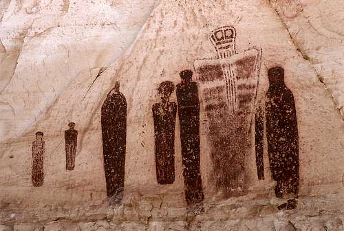 The Great Gallery. Bob Silhler photo.