
-
 10543 Hits
-
 79.04% Score
-
 10 Votes
|
|
Canyon |
|---|---|
|
|
35.20636°N / 106.47923°W |
|
|
Hiking, Trad Climbing, Sport Climbing |
|
|
Spring, Summer, Fall, Winter |
|
|
Overview

La Cueva from the Entrance

Wild Apples
The Sandia Mountains are known for quality climbing on the unique Sandia granite, both sport routes and long trad routes. However, most of the approaches in the Sandias require a 45-minute drive to the top of the mountain, several miles of hiking, and significant elevation change. Upper La Cueva Canyon is the home to many of these routes.
Lower La Cueva Canyon is deliciously different! This canyon is home to moderate 2-4 pitch trad routes, hides a few difficult 1 pitch sport routes, and boasts short approaches (20-30 minutes) both by car and by foot. The steep walls enable it to be hidden and remote despite its proximity to Albuquerque. The unmaintained climber's trail winds in and out of the dense riparian brush, creates some bushwhacking fun, and ascends steep boulder-filled slopes to attain the base of climbs. Near the entrance to the canyon is a wild apple tree, and just past the climb Flake 'n Bake is the tumbled boulder that forms the 'cave' from which the canyon is named.
Within the canyon are three main climbing areas:
1) Flake 'n Bake
2) Lower La Cueva Domes
3) Gemstone Slabs
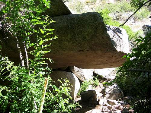
The 'Cave'
Flake 'n Bake
Flake 'n Bake (5.5) is a one-route two-pitch low-angle flake on the north side of the canyon. To reach it, hike up the vague trails on the canyon bottom about 10 minutes. When you find a trail heading north out of the bottom, take it and wind your way to the base of the climb. If you reach the 'cave' that the canyon is named for, you have gone too far. This climb is easy to miss, and hard to spot. Often people pass it and find it on the return.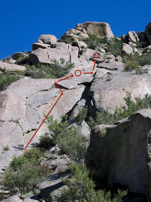
Flake 'n Bake from the Bottom
Lower La Cueva Domes
'Domes' is a misnomer. These are really bulging slabs that are located in the first drainage south from the entrance to the canyon. As I was surveying the canyon, I did not actually make it to the Domes as the July foliage was dense, thorny, and difficult to navigate. I could not find a decent trail (climber's or otherwise) to thrash my way up there.There are 5 climbs on these slabs, with really only 2 moderate routes:
1) Leonardo de Smeari 5.11a - a one-pitch mix of sport and trad
2) Blank Canvas 5.11b/c - one-pitch sport route
3) Mona Feetsa 5.9+ - one-pitch sport route
4) Marco Bolto 5.10b - a one-pitch mix of sport and trad
5) Classic Ramp 5.9 - one-pitch trad over a roof
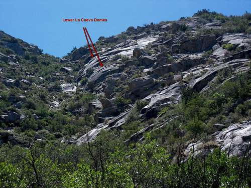
The 'Domes'
Gemstone Slabs
The Gemstone Slabs are further up the canyon past Flake 'n Bake on the south side. To get there head south at the 'cave' and follow the vague trails up and to the left (east) to access the base of the climbs. This area is a huge wall of slabs with some great moderate multi-pitch trad. Some of the more popular climbs include:1) Gemstone 5.8 - 2 pitches
2) Seamingly Hard 5.10b - 2 pitches
3) Sapphire 5.9 - 2 pitches
4) Emerald City 5.9+ - 2 pitches
5) Revenge of the Elderly 5.7 - 3-4 pitches
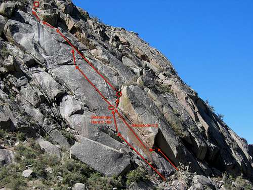
Gemstone Slabs West
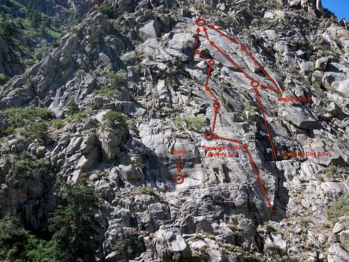
Gemstone Slabs East
Getting There

Start of the Vague Trail
Red Tape
There is a $3 fee for parking.Camping
Dispersed camping is allowed in the Sandias, but there are no designated campgrounds. Fires are not allowed.Maps & Books
The 7.5 USGS map is Sandia Crest (NM).The Cibola National Forest publishes the Sandia Mountain Wilderness Map available locally in Albuquerque at REI near the intersection of Montaño and I-25. It costs about $14.95 and is plasticized for weatherproofing. You can get it for $7 if you go directly to the Cibola National Forest Office off of Osuna. To get there from I-25 head west on Osuna. Take a right onto Chappell Drive. The office will be on the west side of the street in about 1/4 mile.
Probably the best map to purchase is the newer Sandia Mountains – GPS Powered Trail Map by Dharma Maps. It is a 1:45,000 scale topographic map complete with 1:25,000 insets, mileages, and access points. It is printed on waterproof paper and is smaller, more detailed, and more portable than the National Forest map. It can be purchased at Amazon.com for $9.95, and is also available locally at REI near the intersection of Montaño and I-25.
The local climbing book entitled Sandia Rock by Mick Schein is an excellent guide to the area. It can be purchased at REI on Montaño and I-25 for $14.95.