
-
 16026 Hits
-
 78.84% Score
-
 10 Votes
|
|
Canyon |
|---|---|
|
|
35.11212°N / 106.48563°W |
|
|
Hiking, Sport Climbing, Toprope, Canyoneering |
|
|
Spring, Summer, Fall, Winter |
|
|
Overview
Located in the western foothills of the Sandia Mountains, this canyon is named for its large and easily visible granite pour-off. Piedra Lisa is Spanish for “slick rock”, and this canyon is full of slick rock sections of Sandia Granite. Easily accessible, this canyon is a great location for an easy day hike, scrambling, and winter hiking. During the summer months, the canyon can be extremely hot and dry. The lower portion of this canyon is administered by the City of Albuquerque Open Space. The far upper portion is located within the Sandia Mountain Wilderness. Not to be confused with its namesake trail located much farther north in the Sandias, this delightful little canyon is close to Albuquerque and provides an enjoyable excursion.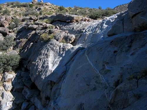
The Large Granite Pour-Off or Dam

Mule Deer Spoor is Everywhere

Rappelling Bolt

Watch for Rattlesnakes!

Prickly Pear Below the Dam
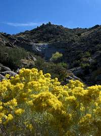
Chamisa in Bloom

Looking across the bridge toward the pour-off
The granite pour-off (or dam as some like to call it) is a favorite of locals who want to get a little practice in rappelling. At the top of the 170’ cliff are several sets of solid anchors. Two are located in the middle of the pour-off, two are located 30 feet to the north, and two are located 30 feet east of the edge of the pour-off on the backside of a large boulder. There is evidence of old ¼ inch bolts that have been chopped both at the top of the pour-off, and also at the top of a prominent crack that ascends the right (south) side of the pour-off.
There is climbing at the large granite face as well. The low-angle crack that ascends the right side of the face shows evidence of climbing. There is also a line of bolts up the center of the slab. On the rock below the center of the slab is a single bolt, presumably for a belayer. Unfortunately, I was unable to find any information about difficulty ratings or names. If anyone has that information, please post it on the addition section of this page and I will be happy to add that here.
Other recreational opportunities include Mountain Biking and Geo-Caching. This open space provides access for Mountain Bikers to the Foothills Trail and Trail #365. Several Geo-Caches are located in the area, but specific details are beyond the scope of this author.
There is an abundance of wildlife in the canyon, although they are difficult to spot. Mule Deer spoor, including both tracks and scat, are everywhere. Unfortunately, the deer themselves are hard to spot due to their well-camouflaged hides, and the density of the brush. Coyotes and fox frequent the area as well, but are rarely seen. Bird species include Canyon Wren, Mountain Chickadee, Northern Flicker, Dark-eyed Junco, and Crissal Thrasher. Rattlesnakes are extremely common in this canyon, so caution must be exercised during the warmer months.
The canyon is also home to plant species such as the ubiquitous Chamisa bush with its bright yellow fall blooms, the Cholla cactus, Mountain Mahogany (a favorite of the Mule Deer), various Juniper species (higher up the canyon), and a wide association of riparian plants found in the canyon bottom.
The American Canyoneering Academy Rating system would consider this canyon very easy at 1A I meaning that it is a non-technical dry canyon that can be accomplished in just a few hours. The round-trip length of the canyon is 2.5 miles. The canyon may be hiked at all times of the year, but summer may be extremely hot and the July-August monsoon season can bring deadly flash floods through the canyon. Do not attempt to hike this canyon during wet weather!!
Canyon Description

Looking West from Above the Pour-Off

Sandia Granite

Rock Wall in the Upper Canyon

Cholla and the Pour-Off
From the parking lot, head across the bridge and follow the wide sandy trail as it winds through the Chamisa and Cholla towards the large grey pour-off. When the trail gets to the wash, you can either head directly up the wash towards the rock wall or follow the trail marked by wooden posts and reflective arrows. A third option continues across the wash and follows a faint unmarked trail up the southern ridge and leads towards the top of the pour-off.
From the base of the large cliff, you can ascend easy rock to the south to gain the trail that leads to the top of the pour-off, or follow the posts and reflective arrows up the slope to the north. This newly blazed trail leads to the top of the pour-off. From the top of the cliff, follow the sandy wash as far back as time allows. At various points, there are more granite slick rock sections, dense riparian growth, and short rock walls to surmount. There are also numerous spur trails that lead out of the canyon. Some interesting (and scenic) diversions leave the canyon bottom and ascend the ridge to the south for fantastic views of Albuquerque, Embudo Canyon, and the Manzano Mountains to the south.
Eventually, a downed barbed-wire fence cuts across the hills next to the canyon bottom. This marks the boundary of the Sandia Mountain Wilderness. As you progress up the canyon bottom from this point, it becomes shallower and steeper. At this juncture, you can continue hiking up the brush-choked canyon bottom, return the way you came, or ascend the south ridge for spectacular views.
Getting There

Undulations of Granite

Above the Dam
From the intersection of I-40 and Tramway, head north on Tramway to the intersection of Tramway and Candelaria. Hang a right (east) on Candelaria and drive for about ½ mile to the T intersection and the stop sign. Turn right (south) onto Camino de la Sierra. The well-marked parking lot is on the left in about ¼ mile.
Red Tape

Granite Slick Rock
There is no fee to use the Piedra Lisa Canyon Open Space. Hunting, discharge of firearms, fireworks, and operation of motor vehicles within the open space is prohibited.
Fires may be allowed with prior permission. Dogs are allowed, but must be on a leash no longer than 8 feet.
The parking lot is gated, and is open from 7AM to 9PM April to October. The area is open from 7AM to 7PM November to March. If hiking into the Sandia Mountain Wilderness, you are allowed to leave your car overnight, just be advised that it will be locked into the parking lot.
Camping
Camping is not permitted in the open space without a permit. Permits can be obtained by calling 505-452-5200.Once beyond the Sandia Mountain Wilderness Boundary, dispersed camping for free is allowed. However, fires are not.
Maps
The 7.5 minute USGS map is Tijeras (NM)The Cibola National Forest publishes the Sandia Mountain Wilderness Map available locally in Albuquerque at REI near the intersection of Montaño and I-25. It costs about $14.95 and is plasticized for weatherproofing. You can get it for $7 if you go directly to the Cibola National Forest Office off of Osuna. To get there from I-25 head west on Osuna. Take a right onto Chappell Drive. The office will be on the west side of the street in about 1/4 mile.
Probably the best map to purchase is the newer Sandia Mountains – GPS Powered Trail Map by Dharma Maps. It is a 1:45,000 scale topographic map complete with 1:25,000 insets, mileages, and access points. It is printed on waterproof paper and is smaller, more detailed, and more portable than the National Forest map. It can be purchased at Amazon.com for $9.95, and is also available locally at REI near the intersection of Montaño and I-25.
External Links
City of Albuquerque Open SpacePiedra Lisa Canyon Open Space Map
Sandia Mountain Hiking Guide Description
Cibola National Forest
American Canyoneering Academy