
|
|
Mountain/Rock |
|---|---|
|
|
39.86580°N / 112.3216°W |
|
|
Juab |
|
|
Hiking |
|
|
Spring, Summer, Fall |
|
|
8060 ft / 2457 m |
|
|
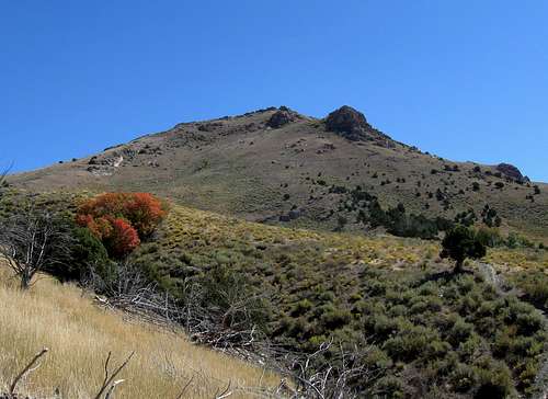
From the west side
Overview
Located to the west of the I-15 interstate, Maple Peak is west of of Eureka Utah and is pretty much a rarely visited peakbaggers goal. With 1168 feet of prominence, it is well down the list at #249 on this list.Yet, I've had my eyes on this one since last year when I topped out on Sabie Mountain and wondered what the peak to the south was. Sabie Mountain and this one could be combined on the same trip or with Tintic Mountain to the east.
Cattle is run on the land but you a good chance to see some deer & proghorn antelope as well as you drive in.
Getting There
From I-15, south of Provo, take the Santaquin exit and head west toward Eureka. From Eureka, continue to go west and a bit south on US 6 but take road 36 to Tintic Junction. From Tintic Junction, take the Cherry Creek road, a good graded dirt road that heads west and I found it was about 11 miles from the Tintic junction to where I turned off of the Cherry Creek road. I then headed up a jeep road located on the north side. For folks with low clearance, park here since you could hike up from that turnoff from the Cherry Creek road if a high clearance 4WD vehicle isn't available and follow the road up towards the peak. It adds some mileage and some elevation gain but it is reasonable.
Route
The route in from the north is fairly straightforward (see map). From the Cherry Creek road to the top it is a bit over 1200 feet of elevation gain and just over two miles. Not bad. If you have a high clearance vehicle with 4WD, you can get closer but how close is up to you.
Note: The register bottle was noted as leaking and if you are the next visitor to the summit, perhaps you could take a new register container and a ziplock baggie to put the register pages in.
Update: Thanks to pfeiffer75 for replacing the register.
Also, you can combine several other peaks with this one while you are out in this area. Sam Grant also did Pinyon and Sabie and ZeeJay had this to say: "Did 5 separate little hikes including Maple Peak. First did 6965. Then 7474, Maple, and 7270 together, starting from the Cherry Creek Rd. Then drove a short distance north on #005 and made a side trip west to 7655. Continued north on #005 and made a side trip to J Hill. Finally, made it up Sabie Mt starting from #005."
Summit visitors and the views from the summit
Thanks to an interest in prominence, others have now made their way to this one. Lists of John has this listing of those who have been to this one:byates
ChrisH
DeanMolen
donnao
GregBronder
jhardink
johnvitz
scgrant (see his GPS track at peakbagger.com)
EricWillhite (check out his trip report at willhiteweb.com)
ZeeJay
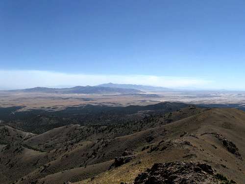
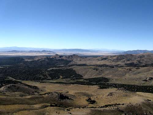
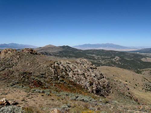
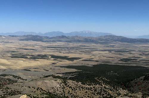
The summit is an outstanding viewpoint as I hope these following pics will show
South
West
North
East
Red Tape
None that I am aware of. The mountain is on BLM land but you do cross a fenceline on the way to the summit. Open and close the gate behind you since while I was there, cattle were active on the mountain. I did not see any "no trespassing" signs. For more information, you might trying contacting:Salt Lake Field Office
2370 South 2300 West
Salt Lake City, UT 84119
Field Office Manager: Mike Nelson
Phone: (801) 977-4300
Fax: (801) 977-4397
utslmail@blm.gov
Camping
There are no campgrounds in the immediate vicinity of Maple Peak although there is ample opportunity to bush camp nearby. Practice the leave no traceimpact type of camping and realize that during hunting season, there may be others who are bush camping in the area. Near Sabie Peak the Vernon Reservoir campground has some possibilities if you want a table and vault toilet facilities. Take your own water.
Weather for nearby Eureka Utah


Other
Take the time to visit the old mining town of Eureka Utah. The town has a couple gas station and convenience stores as well as a cafe or two. A museum is available for those who might be interested in mining history.Eureka
------------------------
From online Utah.com:
Eureka is located approximately seventy miles southwest of Salt Lake City in Juab County. Incorporated as a city in 1892, Eureka became the financial center for the Tintic Mining District, a wealthy gold and silver mining area in Utah and Juab counties. The district was organized in 1869 and by 1899 became one of the top mineral producing areas in Utah. Eureka housed the "Big Four" mines -- Bullion Beck and Champion, Centennial Eureka, Eureka Hill, and Gemini-and later the Chief Consolidated Mining Company. The Chief was developed by the Walter Fitch family, who not only had their own mine in Eureka, but also the company headquarters, family residences, and family cemetery -- a most unique feature in any western mining town.
As with other mining towns, Eureka developed from a camp to a settlement then town. It benefited from competing transportation services of the Union Pacific (1889) and the Denver and Rio Grande Western (1891) railroads. Census statistics indicate the following population figures through 1930, when the impact of the Depression changed its fortunes: 1880 - 122; 1890 - 1,733; 1900 - 3,325; 1910 - 3,829; 1920 - 3,908; 1930 - 3,216. That Eureka's population exhibited ebbs and flows between census years was attributed to the transitory character of a mining town. By the 1980s the population fell below 700.
Eureka's role as the central financial point for the district insured its survival. It housed business establishments, financial institutions, local and county governmental buildings including Eureka City Hall (1899) and a Juab County Courthouse (1892), various churches, and the meeting places for numerous labor, social, and fraternal organizations. Eureka became especially active as a successful political field for Utah's Socialist party. Mining entrepreneurs such as John Q. Packard, John Beck, Jesse Knight, Walter Fitch Sr., and others loomed as important figures in Eureka and Tintic history. A relative calm and peaceful labor environment marked Eureka's past.
The Chief Consolidated operated during the 1930s and into the 1950s, helping to keep Eureka's economy afloat. Small scale mining operations have continued, but most residents work in valley towns and for government services, such as the Tooele Army Depot. Being located on Utah Highway 6, Eureka is on a main trail to the Little Sahara Sand Dunes area. In 1979 Eureka was placed in the National Register of Historic Places as part of the Tintic Mining District Multiple Resource Area, recognizing the importance of remaining buildings and sites.
See: Beth Kay Harris, The Towns of Tintic (1961); Alice P. McCune, History of Juab County (1947); Philip F. Notarianni, Faith, Hope and Prosperity: The Tintic Mining District (1982).
Philip F. Notarianni